
Fasciculus:Thermopylae shoreline changes map.png
Nulla maior resolutio exstat.
Thermopylae_shoreline_changes_map.png (542 × 417 elementa imaginalia, magnitudo fasciculi: 88 chiliocteti, typus MIME: image/png)
Summarium
| Descriptio |
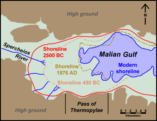
English: Map of Thermopylae area with modern shoreline and reconstructed shorelines of 1872 AD, 480 BC and 2500 BC. Loosely based on figure 3.19 in Geoarchaeology: The Earth-science Approach to Archaeological Interpretation, p. 96. George Robert Rapp, Christopher L. Hill. Yale University Press, 2006. ISBN 0300109660 |
| Datum | |
| Fons | Opus proprium |
| Auctor | ChrisO |
| Permissio (Reusing this file) |
Public domain |
Potestas usoris
| I, the copyright holder of this work, release this work into the public domain. This applies worldwide. In some countries this may not be legally possible; if so: I grant anyone the right to use this work for any purpose, without any conditions, unless such conditions are required by law. |
Historia fasciculi
Presso die vel tempore fasciculum videbis, sicut tunc temporis apparuit.
| Dies/Tempus | Minutio | Dimensiones | Usor | Sententia | |
|---|---|---|---|---|---|
| recentissima | 08:27, 12 Iunii 2011 | | 542 × 417 (88 chiliocteti) | Cplakidas | minor corrections on names |
| 00:00, 1 Octobris 2008 |  | 542 × 417 (31 chiliocteti) | ChrisO | {{Information |Description={{en|1=Map of Thermopylae area with modern shoreline and reconstructed shorelines of 1872 AD, 480 BC and 2500 BC. Loosely based on figure 3.19 in ''Geoarchaeology: The Earth-science Approach to Archaeological Interpretation'', p |
Nexus ad fasciculum
Ad hunc fasciculum nectit:
Usus fasciculi per inceptus Vicimediorum
Quae incepta Vici fasciculo utuntur:
- Usus in ar.wikipedia.org
- Usus in azb.wikipedia.org
- Usus in br.wikipedia.org
- Usus in ca.wikipedia.org
- Usus in da.wikipedia.org
- Usus in de.wikipedia.org
- Usus in el.wikipedia.org
- Usus in en.wikipedia.org
- Usus in fi.wikipedia.org
- Usus in fr.wikipedia.org
- Usus in hr.wikipedia.org
- Usus in hu.wikipedia.org
- Usus in id.wikipedia.org
- Usus in mk.wikipedia.org
- Usus in ru.wikipedia.org
- Usus in sh.wikipedia.org
- Usus in simple.wikipedia.org
- Usus in sr.wikipedia.org
- Usus in tr.wikipedia.org
- Usus in uk.wikipedia.org
- Usus in vi.wikipedia.org
- Usus in zh.wikipedia.org