
Fasciculus:Gulf stream map.gif
Sua resolutio (700 × 612 elementa imaginalia, magnitudo fasciculi: 222 chiliocteti, typus MIME: image/gif)
Summarium

|
This file was moved to Wikimedia Commons from en.wikipedia using a bot script. All source information is still present. It requires review. Additionally, there may be errors in any or all of the information fields; information on this file should not be considered reliable and the file should not be used until it has been reviewed and any needed corrections have been made. Once the review has been completed, this template should be removed. For details about this file, see below. Check now! |
| Descriptio |
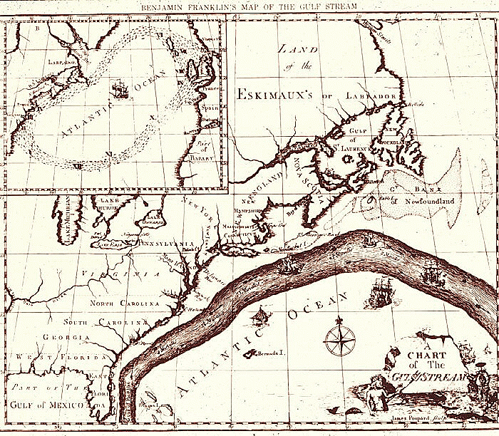
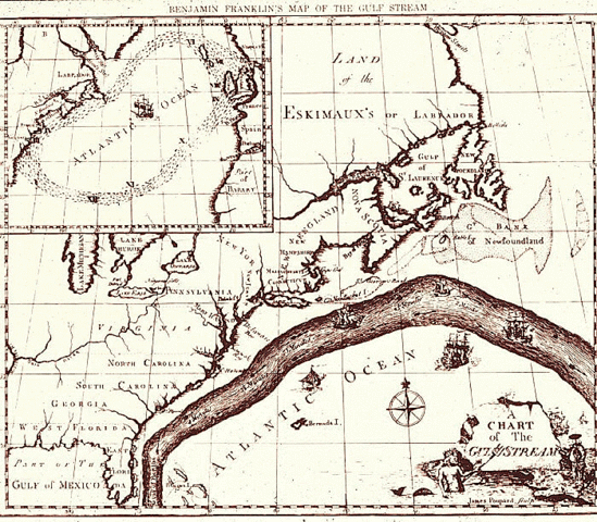
English: Map of the Gulf Stream by Benjamin Franklin. Courtesy of NOAA Photo Library. |
| Datum | 1769 - 1770 |
| Fons | http://oceanexplorer.noaa.gov/library/readings/gulf/media/gulf_bf.html |
| Auctor | Benjamin Franklin |
| Permissio (Reusing this file) |
Public Domain |
Potestas usoris
|
This work is in the public domain in its country of origin and other countries and areas where the copyright term is the author's life plus 70 years or fewer.
| |
| This file has been identified as being free of known restrictions under copyright law, including all related and neighboring rights. | |
Original upload log
Transferred from en.wikipedia to Commons by Sreejithk2000 using CommonsHelper.
- 2010-01-04 09:22 Zeamays 700×612× (227284 bytes) {{Information |Description = Map of the Gulf Stream by Benjamin Franklin. Courtesy of NOAA Photo Library. |Source = http://oceanexplorer.noaa.gov/library/readings/gulf/media/gulf_bf.html |Date = 1769-1770 |Author = Benjami
Historia fasciculi
Presso die vel tempore fasciculum videbis, sicut tunc temporis apparuit.
| Dies/Tempus | Minutio | Dimensiones | Usor | Sententia | |
|---|---|---|---|---|---|
| recentissima | 06:23, 5 Iunii 2010 | | 700 × 612 (222 chiliocteti) | File Upload Bot (Magnus Manske) | {{BotMoveToCommons|en.wikipedia|year={{subst:CURRENTYEAR}}|month={{subst:CURRENTMONTHNAME}}|day={{subst:CURRENTDAY}}}} {{Information |Description={{en|Map of the Gulf Stream by Benjamin Franklin. Courtesy of NOAA Photo Library.}} |Source=Transferred from |
Nexus ad fasciculum
Ad hunc fasciculum nectunt:
Usus fasciculi per inceptus Vicimediorum
Quae incepta Vici fasciculo utuntur:
- Usus in da.wikipedia.org
- Usus in da.wikibooks.org
- Usus in en.wikipedia.org
- Usus in fr.wikipedia.org
- Usus in hy.wikipedia.org
- Usus in id.wikipedia.org
- Usus in kn.wikipedia.org
- Usus in ko.wikipedia.org
- Usus in mk.wikipedia.org
- Usus in oc.wikipedia.org
- Usus in si.wikipedia.org
- Usus in ta.wikipedia.org
- Usus in tl.wikipedia.org