
Fasciculus:Luftbild bln-schmoeckwitz.jpg

Mensura huius perspectionis: 800 × 475 elementa imaginalia. Aliae mensurae: 320 × 190 elementa imaginalia | 640 × 380 elementa imaginalia | 1 280 × 760 elementa imaginalia.
Sua resolutio (1 280 × 760 elementa imaginalia, magnitudo fasciculi: 293 chiliocteti, typus MIME: image/jpeg)
Summarium
| Descriptio |
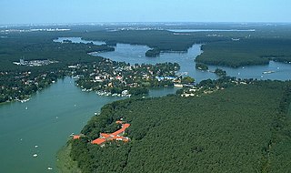
Deutsch: Luftbild von Berlin-Schmöckwitz (Bezirk Treptow-Köpenick) und der Seenregion in Berlins Südosten, Blickrichtung: NNW.; Im Vordergrund der Zeuthener See, dahinter der Lange See. Im Bildhintergrund der Müggelsee
English: Aerial view of Schmöckwitz, Treptow-Köpenick, Berlin and the lake region in the southeast of Berlin, view direction NNW. |
||||||||
| Datum | |||||||||
| Fons | Opus proprium | ||||||||
| Auctor | Matthias Renner (Marathoni62) | ||||||||
| Permissio (Reusing this file) |
|

| Camera location | | View this and other nearby images on: OpenStreetMap |
|---|
Historia fasciculi
Presso die vel tempore fasciculum videbis, sicut tunc temporis apparuit.
| Dies/Tempus | Minutio | Dimensiones | Usor | Sententia | |
|---|---|---|---|---|---|
| recentissima | 23:31, 28 Aprilis 2006 | | 1 280 × 760 (293 chiliocteti) | BLueFiSH.as | {{Information| |Description= *{{en|aerial view of Berlin-Schmöckwitz and the lake region in the southeast of Berlin, view direction NNW}} *{{de|Luftbild von Berlin-Schmöckwitz und der Seenregion in Berlins Südosten, Blickrichtung: NNW}} |Source= [[:de: |
Nexus ad fasciculum
Nullae paginae hoc fasciculo utuntur.
Usus fasciculi per inceptus Vicimediorum
Quae incepta Vici fasciculo utuntur:
- Usus in af.wikipedia.org
- Usus in arz.wikipedia.org
- Usus in be-tarask.wikipedia.org
- Usus in bn.wikipedia.org
- Usus in ceb.wikipedia.org
- Usus in cs.wikipedia.org
- Usus in da.wikipedia.org
- Usus in de.wikipedia.org
- Usus in el.wikipedia.org
- Usus in en.wikipedia.org
- Usus in eo.wikipedia.org
- Usus in eu.wikipedia.org
- Usus in fa.wikipedia.org
- Usus in fr.wikipedia.org
- Usus in hy.wikipedia.org
- Usus in id.wikipedia.org
- Usus in io.wikipedia.org
- Usus in it.wikipedia.org
- Usus in ja.wikipedia.org
- Usus in ka.wikipedia.org
- Usus in ms.wikipedia.org
- Usus in no.wikipedia.org
- Usus in pl.wikipedia.org
- Usus in pt.wikipedia.org
- Usus in roa-tara.wikipedia.org
- Usus in ro.wikipedia.org
- Usus in ru.wikipedia.org
- Usus in sh.wikipedia.org
- Usus in sl.wikipedia.org
- Usus in sr.wikipedia.org
- Usus in sv.wikipedia.org
- Usus in tl.wikipedia.org
View more global usage of this file.