
Fasciculus:Administrative map of Gujarat.png

Mensura huius perspectionis: 756 × 600 elementa imaginalia. Aliae mensurae: 303 × 240 elementa imaginalia | 605 × 480 elementa imaginalia | 968 × 768 elementa imaginalia | 1 280 × 1 015 elementa imaginalia | 2 560 × 2 031 elementa imaginalia | 3 014 × 2 391 elementa imaginalia.
Sua resolutio (3 014 × 2 391 elementa imaginalia, magnitudo fasciculi: 660 chiliocteti, typus MIME: image/png)
Summarium
| Descriptio |
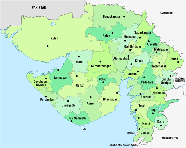
Deutsch: Administrative Karte von Gujarat in der Verwaltungsgliederung seit 15.08.2013
English: Administrative map of Gujarat with the administrative divisions since August 15, 2013 |
||
| Datum | see file history | ||
| Fons | Opus proprium, using this map | ||
| Auctor | Maximilian Dörrbecker (Chumwa) | ||
| Permissio (Reusing this file) |
I, the copyright holder of this work, hereby publish it under the following licenses:
This file is licensed under the Creative Commons Attribution-Share Alike 3.0 Unported license.
Tibi typum permissionis ligere licet. |
||
| Other versions |
|


.svg)

|
This locator map image could be re-created using vector graphics as an SVG file. This has several advantages; see Commons:Media for cleanup for more information. If an SVG form of this image is available, please upload it and afterwards replace this template with
{{vector version available|new image name}}.
It is recommended to name the SVG file “Administrative map of Gujarat.svg”—then the template Vector version available (or Vva) does not need the new image name parameter. |

|
This map has been made or improved in the German Kartenwerkstatt (Map Lab). You can propose maps to improve as well.
|
Historia fasciculi
Presso die vel tempore fasciculum videbis, sicut tunc temporis apparuit.
| Dies/Tempus | Minutio | Dimensiones | Usor | Sententia | |
|---|---|---|---|---|---|
| recentissima | 05:03, 19 Novembris 2013 | | 3 014 × 2 391 (660 chiliocteti) | Chumwa | == {{int:filedesc}} == {{Information |Description= {{de|Administrative Karte von Gujarat in der Verwaltungsgliederung seit 15.08.2013}} {{en|Administrative map of Gujarat with the administrative divisions since August 15... |
Nexus ad fasciculum
Nullae paginae hoc fasciculo utuntur.
Usus fasciculi per inceptus Vicimediorum
Quae incepta Vici fasciculo utuntur:
- Usus in bg.wikipedia.org
- Usus in bh.wikipedia.org
- टेम्पलेट:गुजरात
- अहमदाबाद जिला
- अमरेली जिला
- आनंद जिला
- बनासकांठा जिला
- भरूच जिला
- भावनगर जिला
- दाहोद जिला
- दांग जिला
- गांधीनगर जिला
- जामनगर जिला
- जूनागढ़ जिला
- खेड़ा जिला
- कच्छ जिला
- महीसागर जिला
- मेहसाणा जिला
- मोरबी जिला
- नर्मदा जिला
- नवसारी जिला
- पंचमहल जिला
- पाटन जिला
- पोरबंदर जिला
- राजकोट जिला
- साबरकांठा जिला
- सूरत जिला
- सुरेंद्रनगर जिला
- तापी जिला
- वड़ोदरा जिला
- वलसाड़ जिला
- अरावली जिला
- बोटाद जिला
- छोटा उदयपुर जिला
- देवभूमि द्वारका जिला
- गिर सोमनाथ जिला
- Usus in bn.wikipedia.org
- Usus in ca.wikipedia.org
View more global usage of this file.