
Fasciculus:Val di Susa mappa.png

Mensura huius perspectionis: 800 × 532 elementa imaginalia. Aliae mensurae: 320 × 213 elementa imaginalia | 640 × 425 elementa imaginalia | 1 024 × 681 elementa imaginalia | 1 280 × 851 elementa imaginalia | 1 625 × 1 080 elementa imaginalia.
Sua resolutio (1 625 × 1 080 elementa imaginalia, magnitudo fasciculi: 769 chiliocteti, typus MIME: image/png)
Summarium

|
This map image could be re-created using vector graphics as an SVG file. This has several advantages; see Commons:Media for cleanup for more information. If an SVG form of this image is available, please upload it and afterwards replace this template with
{{vector version available|new image name}}.
It is recommended to name the SVG file “Val di Susa mappa.svg”—then the template Vector version available (or Vva) does not need the new image name parameter. |
| Descriptio |
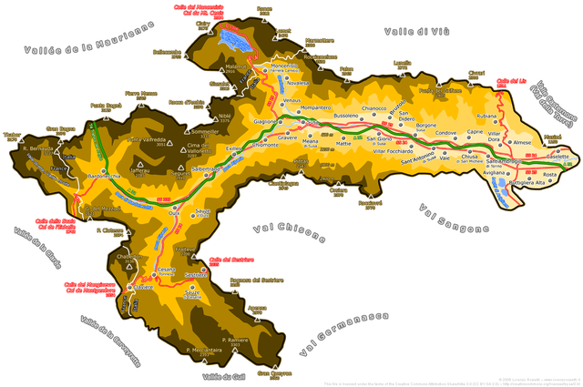
English: Map of Susa Valley, Piemonte, Italy
Italiano: Mappa della Valle di Susa
Deutsch: Karte des Susatals in Italien |
| Datum | |
| Fons | map drawn by Duvilar (Lorenzo Rossetti) |
| Auctor | Duvilar (Lorenzo Rossetti) |
| Permissio (Reusing this file) |
I, the copyright holder of this work, hereby publish it under the following license: This file is licensed under the Creative Commons Attribution-Share Alike 3.0 Unported license.
va necessariamente accompagnata dal nome del sottoscritto autore Lorenzo Rossetti. Un utilizzo senza indicazione della paternità dell'opera sarà considerato come violazione del diritto d'autore. Contatto per maggiori informazioni. The publication of this image outside Wikipedia must be accompanied by the name of the undersigned author Lorenzo Rossetti. Its use without indication of the author's name will be considered as copyright violation. Contact for more information. |
Historia fasciculi
Presso die vel tempore fasciculum videbis, sicut tunc temporis apparuit.
| Dies/Tempus | Minutio | Dimensiones | Usor | Sententia | |
|---|---|---|---|---|---|
| recentissima | 17:26, 9 Ianuarii 2011 | | 1 625 × 1 080 (769 chiliocteti) | Duvilar | new version |
| 10:22, 3 Augusti 2010 |  | 1 625 × 1 080 (823 chiliocteti) | Duvilar | Nuova versione più completa More complete new version | |
| 12:46, 29 Augusti 2009 |  | 2 400 × 1 488 (903 chiliocteti) | Duvilar | Aggiunti i Comuni mancanti e le parti della Valle di Susa sotto amministrazione francese o congiunta italo-francese (Moncenisio e Valle Stretta, confini sullo spartiacque del 1861 e successive rettifiche del 1947). | |
| 17:04, 2 Septembris 2006 |  | 2 390 × 1 442 (559 chiliocteti) | Duvilar | == Dettagli == {{Information| |Description ={{english}} Map of Susa Valley, Piemonte, Italy {{italian}} Mappa della Valle di Susa |Source = map drawn by Duvilar |Date = 02 Sep. 2006 |Author = Duvilar |Permiss |
Nexus ad fasciculum
Ad hunc fasciculum nectit:
Usus fasciculi per inceptus Vicimediorum
Quae incepta Vici fasciculo utuntur:
- Usus in ar.wikipedia.org
- Usus in bg.wikipedia.org
- Usus in br.wikipedia.org
- Usus in ca.wikipedia.org
- Usus in de.wikipedia.org
- Usus in en.wikipedia.org
- Usus in es.wikipedia.org
- Usus in fr.wikipedia.org
- Usus in it.wikipedia.org
- Usus in it.wikinews.org
- Usus in it.wikivoyage.org
- Usus in ja.wikipedia.org
- Usus in mt.wikipedia.org
- Usus in nl.wikipedia.org
- Usus in pms.wikipedia.org
- Usus in pt.wikipedia.org
- Usus in ru.wikipedia.org
- Usus in sl.wikipedia.org
- Usus in zh.wikipedia.org