
Fasciculus:Relief map of Texas.png
Mensura huius perspectionis: 606 × 599 elementa imaginalia. Aliae mensurae: 243 × 240 elementa imaginalia | 485 × 480 elementa imaginalia | 1 000 × 989 elementa imaginalia.
Sua resolutio (1 000 × 989 elementa imaginalia, magnitudo fasciculi: 1.28 megaocteti, typus MIME: image/png)
Summarium
| Descriptio |
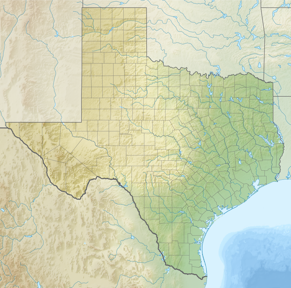
Русский: Физическая карта штата Техас (США). English: Relief map of Texas (USA). |
| Datum | |
| Fons |
|
| Auctor | Nzeemin |
| Other versions |
<gallery>File:USA Texas location
|
Potestas usoris
I, the copyright holder of this work, hereby publish it under the following license:
This file is licensed under the Creative Commons Attribution-Share Alike 3.0 Unported license.
- Tibi licet:
- communicare – copiare, distribuere et committere hoc opus
- to remix – to adapt the work
- His condicionibus:
- attributio – You must give appropriate credit, provide a link to the license, and indicate if changes were made. You may do so in any reasonable manner, but not in any way that suggests the licensor endorses you or your use.
- aequa parte – If you remix, transform, or build upon the material, you must distribute your contributions under the same or compatible license as the original.
Historia fasciculi
Presso die vel tempore fasciculum videbis, sicut tunc temporis apparuit.
| Dies/Tempus | Minutio | Dimensiones | Usor | Sententia | |
|---|---|---|---|---|---|
| recentissima | 13:40, 14 Octobris 2012 | | 1 000 × 989 (1.28 megaocteti) | Nzeemin | User created page with UploadWizard |
Nexus ad fasciculum
Ad hunc fasciculum nectit:
Usus fasciculi per inceptus Vicimediorum
Quae incepta Vici fasciculo utuntur:
- Usus in als.wikipedia.org
- Usus in ar.wikipedia.org
- Usus in ast.wikipedia.org
- Usus in azb.wikipedia.org
- کون، تکزاس
- سان-خاسینتو ساواشی
- کانادلاریا، تکزاس
- بوکیلاس، تکزاس
- چری اسپرینق، تکزاس
- کرباپل، تکزاس
- قریپتاون، تکزاس
- ویلو سیتی، تکزاس
- بلومنتال، تکزاس
- قریت وود شوقر لند، تکزاس
- استونوال تکزاس
- بووت، تکزاس
- کینقزلند، تکزاس
- برلی، تکزاس
- پیترز، تکزاس
- چسترویل، تکزاس
- دو، تکزاس
- رکسویل، تکزاس
- قلن فلورا، تکزاس
- هانت، تکزاس
- هارپر، تکزاس
- کنت، تکزاس
- سینکو رانچ، تکزاس
- کاتون سنتر، تکزاس
- اسپید، تکزاس
- ویتهرال، تکزاس
- فیلدتون، تکزاس
- بولا، تکزاس
- جرارد، تکزاس
- فلووانا، تکزاس
- کلوز سیتی، تکزاس
- افتن، تکزاس
- قراسلند، تکزاس
- آکوف، تکزاس
- سونزون، تکزاس
- مونتاین هوم، تکزاس
- تایتون، تکزاس
- نازئیرت، تکزاس
- کراب، تکزاس
- نیو هوم، تکزاس
- تاسکوزا، تکزاس
- کوتبرت، تکزاس
- تاونر، تکزاس
- آلتایر، تکزاس
- تی پی سیتی، تکزاس
View more global usage of this file.