
Fasciculus:Maker Heights - geograph.org.uk - 705172.jpg
Mensura huius perspectionis: 638 × 599 elementa imaginalia. Aliae mensurae: 256 × 240 elementa imaginalia | 511 × 480 elementa imaginalia | 640 × 601 elementa imaginalia.
Sua resolutio (640 × 601 elementa imaginalia, magnitudo fasciculi: 148 chiliocteti, typus MIME: image/jpeg)
Summarium
| Descriptio |
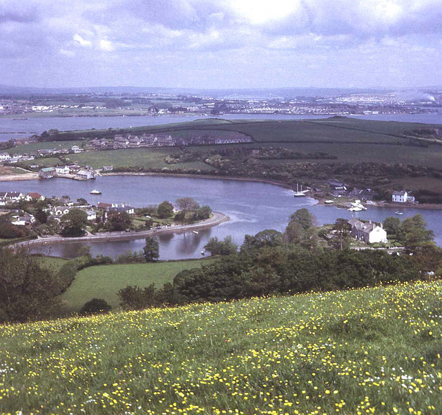
English: Maker Heights View north from steep slope of Maker Heights. Below is Millbrook Lake with Foss Point splitting its headwaters to the left and Insworke village on the opposite side. St John's Lake, Torpoint and the Tamar Road Bridge beyond. |
| Datum | |
| Fons | From geograph.org.uk |
| Auctor | Trevor Rickard |
| Attributio (required by the license) | Trevor Rickard / Maker Heights / |
| Camera location | | View this and other nearby images on: OpenStreetMap |
|---|
_heading:0.00&language=la)
| Object location | | View this and other nearby images on: OpenStreetMap |
|---|
_heading:0.00&language=la)
Potestas usoris

|
This image was taken from the Geograph project collection. See this photograph's page on the Geograph website for the photographer's contact details. The copyright on this image is owned by Trevor Rickard and is licensed for reuse under the Creative Commons Attribution-ShareAlike 2.0 license.
|
This file is licensed under the Creative Commons Attribution-Share Alike 2.0 Generic license.
Attributio: Trevor Rickard
- Tibi licet:
- communicare – copiare, distribuere et committere hoc opus
- to remix – to adapt the work
- His condicionibus:
- attributio – You must give appropriate credit, provide a link to the license, and indicate if changes were made. You may do so in any reasonable manner, but not in any way that suggests the licensor endorses you or your use.
- aequa parte – If you remix, transform, or build upon the material, you must distribute your contributions under the same or compatible license as the original.
Historia fasciculi
Presso die vel tempore fasciculum videbis, sicut tunc temporis apparuit.
| Dies/Tempus | Minutio | Dimensiones | Usor | Sententia | |
|---|---|---|---|---|---|
| recentissima | 22:26, 18 Februarii 2011 | | 640 × 601 (148 chiliocteti) | GeographBot | == {{int:filedesc}} == {{Information |description={{en|1=Maker Heights View north from steep slope of Maker Heights. Below is Millbrook Lake with Foss Point splitting its headwaters to the left and Insworke village on the opposite side. St John's Lake, To |
Nexus ad fasciculum
Ad hunc fasciculum nectit:
Usus fasciculi per inceptus Vicimediorum
Quae incepta Vici fasciculo utuntur: