
Fasciculus:Kansai Airport Map.png

Mensura huius perspectionis: 800 × 504 elementa imaginalia. Aliae mensurae: 320 × 201 elementa imaginalia | 640 × 403 elementa imaginalia | 1 024 × 645 elementa imaginalia | 1 280 × 806 elementa imaginalia | 2 560 × 1 612 elementa imaginalia | 4 500 × 2 833 elementa imaginalia.
Sua resolutio (4 500 × 2 833 elementa imaginalia, magnitudo fasciculi: 970 chiliocteti, typus MIME: image/png)
Summarium
| Descriptio |
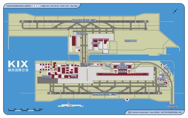
English: Osaka Kansai International Airport Map
Deutsch: Karte Flughafen Osaka Kansai |
| Datum | |
| Fons | Opus proprium |
| Auctor | CellarDoor85 (Robert Aehnelt) |
| Permissio (Reusing this file) |
I, the copyright holder of this work, hereby publish it under the following license: This file is licensed under the Creative Commons Attribution 3.0 Unported license.
|
Historia fasciculi
Presso die vel tempore fasciculum videbis, sicut tunc temporis apparuit.
| Dies/Tempus | Minutio | Dimensiones | Usor | Sententia | |
|---|---|---|---|---|---|
| recentissima | 17:39, 10 Decembris 2016 | | 4 500 × 2 833 (970 chiliocteti) | DerLudonaut | {{Information |Description ={{en|1=Osaka Kansai International Airport Map}} {{de|1=Karte Flughafen Osaka Kansai}} |Source ={{own}} |Author =CellarDoor85 (Robert Aehnelt) |Date =2012-12 |Permission... |
Nexus ad fasciculum
Ad hunc fasciculum nectit:
Usus fasciculi per inceptus Vicimediorum
Quae incepta Vici fasciculo utuntur:
- Usus in ast.wikipedia.org
- Usus in bn.wikipedia.org
- Usus in ca.wikipedia.org
- Usus in de.wikipedia.org
- Usus in en.wikipedia.org
- Usus in eu.wikipedia.org
- Usus in fr.wikipedia.org
- Usus in ja.wikipedia.org
- Usus in vi.wikipedia.org
- Usus in www.wikidata.org