
Fasciculus:Kamarivermap.png
Nulla maior resolutio exstat.
Kamarivermap.png (500 × 500 elementa imaginalia, magnitudo fasciculi: 157 chiliocteti, typus MIME: image/png)
Summarium
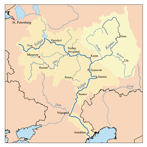
| Descriptio | This is a map of the Volga River system with the Kama River highlighted. I, Karl Musser, created it based on USGS data. |
| Datum | 14 September 2006 (original upload date) |
| Fons | No machine-readable source provided. Own work assumed (based on copyright claims). |
| Auctor | No machine-readable author provided. Kmusser assumed (based on copyright claims). |
Potestas usoris
I, the copyright holder of this work, hereby publish it under the following license:
This file is licensed under the Creative Commons Attribution-Share Alike 2.5 Generic license.
- Tibi licet:
- communicare – copiare, distribuere et committere hoc opus
- to remix – to adapt the work
- His condicionibus:
- attributio – You must give appropriate credit, provide a link to the license, and indicate if changes were made. You may do so in any reasonable manner, but not in any way that suggests the licensor endorses you or your use.
- aequa parte – If you remix, transform, or build upon the material, you must distribute your contributions under the same or compatible license as the original.
Historia fasciculi
Presso die vel tempore fasciculum videbis, sicut tunc temporis apparuit.
| Dies/Tempus | Minutio | Dimensiones | Usor | Sententia | |
|---|---|---|---|---|---|
| recentissima | 17:07, 23 Iulii 2007 | | 500 × 500 (157 chiliocteti) | Kmusser | Ural river fix |
| 14:50, 17 Octobris 2006 |  | 500 × 500 (39 chiliocteti) | Kmusser | ||
| 19:01, 14 Septembris 2006 |  | 500 × 500 (38 chiliocteti) | Kmusser | This is a map of the Volga River system with the Kama River highlighted. I, Karl Musser, created it based on USGS data. {{self|cc-by-sa-2.5}} Category:Maps of rivers |
Nexus ad fasciculum
Nullae paginae hoc fasciculo utuntur.
Usus fasciculi per inceptus Vicimediorum
Quae incepta Vici fasciculo utuntur:
- Usus in af.wikipedia.org
- Usus in azb.wikipedia.org
- Usus in bs.wikipedia.org
- Usus in ca.wikipedia.org
- Usus in cs.wikipedia.org
- Usus in da.wikipedia.org
- Usus in de.wikipedia.org
- Usus in en.wikipedia.org
- Usus in eo.wikipedia.org
- Usus in es.wikipedia.org
- Usus in et.wikipedia.org
- Usus in fi.wikipedia.org
- Usus in fr.wikipedia.org
- Usus in hi.wikipedia.org
- Usus in hr.wikipedia.org
- Usus in id.wikipedia.org
- Usus in it.wikipedia.org
- Usus in ja.wikipedia.org
- Usus in lfn.wikipedia.org
- Usus in lld.wikipedia.org
- Usus in mk.wikipedia.org
- Usus in nl.wikipedia.org
- Usus in nn.wikipedia.org
- Usus in no.wikipedia.org
- Usus in pl.wikipedia.org
- Usus in pl.wiktionary.org
View more global usage of this file.