
Fasciculus:Hennepin County Minnesota Incorporated and Unincorporated areas Minneapolis Highlighted.svg

Size of this PNG preview of this SVG file: 800 × 485 elementa imaginalia. Aliae mensurae: 320 × 194 elementa imaginalia | 640 × 388 elementa imaginalia | 1 024 × 621 elementa imaginalia | 1 280 × 776 elementa imaginalia | 2 560 × 1 552 elementa imaginalia | 1 310 × 794 elementa imaginalia.
Sua resolutio (fasciculus SVG, nominale 1 310 × 794 elementa imaginalia, magnitudo fasciculi: 1.19 megaocteti)
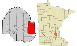
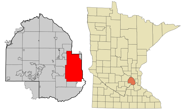
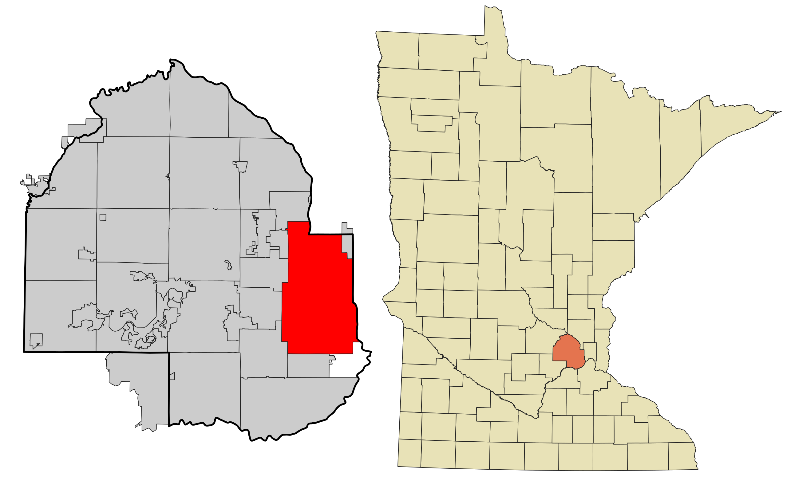
| Descriptio | This map shows the incorporated and unincorporated areas in Hennepin County, Minnesota, highlighting Minneapolis in red. It was created with a custom script with US Census Bureau data and modified with Inkscape. |
| Datum | |
| Fons | My own work, based on public domain information. Based on similar map concepts by Ixnayonthetimmay |
| Auctor | Arkyan |
| SVG genesis |
I, the copyright holder of this work, hereby publish it under the following licenses:

|
Licet hoc documentum exscribere vel distribuere vel demutare sub GNU Liberarum Litterarum Licentiae conditionibus in editione 1.2 aut in ulla editione recentiori a Fundatione Liberarum Programmationis Partium publicata; praeterquam Sectiones Immutabiles et Verba Involucra Adversa et Aversa. Licentiae exemplar praesto est in sectione intitulata GNU Free Documentation License. |
| This file is licensed under the Creative Commons Attribution-Share Alike 3.0 Unported license. | ||
| ||
| This licensing tag was added to this file as part of the GFDL licensing update. |
This file is licensed under the Creative Commons Attribution-Share Alike 2.5 Generic, 2.0 Generic and 1.0 Generic license.
- Tibi licet:
- communicare – copiare, distribuere et committere hoc opus
- to remix – to adapt the work
- His condicionibus:
- attributio – You must give appropriate credit, provide a link to the license, and indicate if changes were made. You may do so in any reasonable manner, but not in any way that suggests the licensor endorses you or your use.
- aequa parte – If you remix, transform, or build upon the material, you must distribute your contributions under the same or compatible license as the original.
Tibi typum permissionis ligere licet.
Historia fasciculi
Presso die vel tempore fasciculum videbis, sicut tunc temporis apparuit.
| Dies/Tempus | Minutio | Dimensiones | Usor | Sententia | |
|---|---|---|---|---|---|
| recentissima | 01:18, 3 Februarii 2021 | | 1 310 × 794 (1.19 megaocteti) | SpeedMcCool | update for 2021 |
| 19:01, 17 Octobris 2007 |  | 850 × 550 (205 chiliocteti) | ArkyBot~commonswiki | {{Information |Description=This map shows the incorporated and unincorporated areas in Hennepin County, Minnesota, highlighting Minneapolis in red. |
Nexus ad fasciculum
Ad hunc fasciculum nectit:
Usus fasciculi per inceptus Vicimediorum
Quae incepta Vici fasciculo utuntur:
- Usus in af.wikipedia.org
- Usus in ang.wikipedia.org
- Usus in ar.wikipedia.org
- Usus in arz.wikipedia.org
- Usus in ast.wikipedia.org
- Usus in azb.wikipedia.org
- Usus in bn.wikipedia.org
- Usus in br.wikipedia.org
- Usus in ca.wikipedia.org
- Usus in de.wikipedia.org
- Usus in el.wikipedia.org
- Usus in en.wikipedia.org
- Usus in eo.wikipedia.org
- Usus in es.wikipedia.org
- Usus in eu.wikipedia.org
- Usus in fa.wikipedia.org
- Usus in fi.wikipedia.org
- Usus in fo.wikipedia.org
- Usus in fr.wikipedia.org
- Usus in fr.wikinews.org
- Usus in fy.wikipedia.org
- Usus in ga.wikipedia.org
- Usus in gd.wikipedia.org
- Usus in gl.wikipedia.org
- Usus in gu.wikipedia.org
- Usus in he.wikipedia.org
- Usus in ht.wikipedia.org
- Usus in hu.wikipedia.org
- Usus in hy.wikipedia.org
- Usus in ia.wikipedia.org
- Usus in id.wikipedia.org
- Usus in incubator.wikimedia.org
- Usus in it.wikipedia.org
- Usus in ja.wikipedia.org
- Usus in kab.wikipedia.org
- Usus in kn.wikipedia.org
- Usus in ku.wikipedia.org
- Usus in kw.wikipedia.org
- Usus in ln.wikipedia.org
- Usus in lv.wikipedia.org
View more global usage of this file.