
Fasciculus:Equatorialguineamap.png
Nulla maior resolutio exstat.
Equatorialguineamap.png (728 × 496 elementa imaginalia, magnitudo fasciculi: 236 chiliocteti, typus MIME: image/png)
Summarium
| Descriptio |
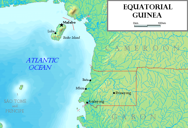
English: Map of Equatorial Guinea. The island of Annobón is not shown. |
| Datum | |
| Fons | Based on a map from http://www.demis.nl/wms/mapclip.htm |
| Auctor | Made by the uploader. |
| Other versions |
|

Potestas usoris
I, the copyright holder of this work, hereby publish it under the following licenses:

|
Licet hoc documentum exscribere vel distribuere vel demutare sub GNU Liberarum Litterarum Licentiae conditionibus in editione 1.2 aut in ulla editione recentiori a Fundatione Liberarum Programmationis Partium publicata; praeterquam Sectiones Immutabiles et Verba Involucra Adversa et Aversa. Licentiae exemplar praesto est in sectione intitulata GNU Free Documentation License. |
| This file is licensed under the Creative Commons Attribution-Share Alike 3.0 Unported license. | ||
| ||
| This licensing tag was added to this file as part of the GFDL licensing update. |
This file is licensed under the Creative Commons Attribution-Share Alike 2.5 Generic, 2.0 Generic and 1.0 Generic license.
- Tibi licet:
- communicare – copiare, distribuere et committere hoc opus
- to remix – to adapt the work
- His condicionibus:
- attributio – You must give appropriate credit, provide a link to the license, and indicate if changes were made. You may do so in any reasonable manner, but not in any way that suggests the licensor endorses you or your use.
- aequa parte – If you remix, transform, or build upon the material, you must distribute your contributions under the same or compatible license as the original.
Tibi typum permissionis ligere licet.
This image is in the public domain because it came from the site https://www.demis.nl/products/web-map-server/examples/ and was released by the copyright holder. Permission is granted to copy, distribute and/or modify this map since it is based on free of copyright images from: www.demis.nl. See also approval email on de.wp and its clarification.
|
| This work has been released into the public domain by its copyright holder, www.demis.nl. This applies worldwide. In some countries this may not be legally possible; if so: www.demis.nl grants anyone the right to use this work for any purpose, without any conditions, unless such conditions are required by law.
|
Historia fasciculi
Presso die vel tempore fasciculum videbis, sicut tunc temporis apparuit.
| Dies/Tempus | Minutio | Dimensiones | Usor | Sententia | |
|---|---|---|---|---|---|
| recentissima | 18:51, 18 Iulii 2006 | | 728 × 496 (236 chiliocteti) | Tonym88~commonswiki | Map of Equatorial Guinea, made by the uploader. Based on a map from http://www.demis.nl/wms/mapclip.htm. The island of Annobón is not shown. == Licensing == {{self2|GFDL|cc-by-sa-2.5,2.0,1.0}} {{demis-pd}} Category:Equatorial Guinea [[Category:Map |
Nexus ad fasciculum
Nullae paginae hoc fasciculo utuntur.
Usus fasciculi per inceptus Vicimediorum
Quae incepta Vici fasciculo utuntur:
- Usus in ar.wikipedia.org
- Usus in bg.wikipedia.org
- Usus in br.wikipedia.org
- Usus in de.wikipedia.org
- Usus in el.wikipedia.org
- Usus in en.wikipedia.org
- Usus in eo.wikipedia.org
- Usus in es.wikipedia.org
- Usus in fi.wikipedia.org
- Usus in gd.wikipedia.org
- Usus in io.wikipedia.org
- Usus in mi.wikipedia.org
- Usus in mzn.wikipedia.org
- Usus in nl.wikipedia.org
- Usus in pl.wikipedia.org
- Usus in tr.wiktionary.org
- Usus in uk.wikipedia.org
- Usus in vec.wikipedia.org