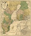
Fasciculus:Charta öfver Svea och Göta Riken med Finland och Norland.jpg

Mensura huius perspectionis: 515 × 599 elementa imaginalia. Aliae mensurae: 206 × 240 elementa imaginalia | 412 × 480 elementa imaginalia | 660 × 768 elementa imaginalia | 880 × 1 024 elementa imaginalia | 1 760 × 2 048 elementa imaginalia | 5 791 × 6 739 elementa imaginalia.
Sua resolutio (5 791 × 6 739 elementa imaginalia, magnitudo fasciculi: 9.05 megaocteti, typus MIME: image/jpeg)
Historia fasciculi
Presso die vel tempore fasciculum videbis, sicut tunc temporis apparuit.
| Dies/Tempus | Minutio | Dimensiones | Usor | Sententia | |
|---|---|---|---|---|---|
| recentissima | 08:37, 3 Iunii 2022 |  | 5 791 × 6 739 (9.05 megaocteti) | DivadH | Radically increased resolution compared to previous file |
| 08:10, 17 Novembris 2005 |  | 737 × 877 (359 chiliocteti) | Tomisti | ''Charta öfver Svea och Göta Riken med Finland och Norland : afritade i Stockholm år 1747'' A map of Sweden and Finland, made in Stockholm, Sweden, 1747. Made by: Åkerland, E. & Biurman, Georg Published: 1801 Source: [http://www-db.helsinki.fi/cg |
Nexus ad fasciculum
Ad hunc fasciculum nectit:
Usus fasciculi per inceptus Vicimediorum
Quae incepta Vici fasciculo utuntur:
- Usus in be.wikipedia.org
- Usus in da.wikipedia.org
- Usus in de.wikisource.org
- Usus in en.wikipedia.org
- Usus in es.wikipedia.org
- Usus in et.wikipedia.org
- Usus in fa.wikipedia.org
- Usus in fi.wikipedia.org
- Usus in fr.wikipedia.org
- Usus in ja.wikipedia.org
- Usus in kk.wikipedia.org
- Usus in ko.wikipedia.org
- Usus in nn.wikipedia.org
- Usus in no.wikipedia.org
- Usus in ru.wikipedia.org
- Usus in sk.wikipedia.org
- Usus in sq.wikipedia.org
- Usus in sv.wikipedia.org
- Usus in uk.wikipedia.org


