
Fasciculus:Census Regions and Divisions.PNG
Mensura huius perspectionis: 788 × 600 elementa imaginalia. Aliae mensurae: 315 × 240 elementa imaginalia | 631 × 480 elementa imaginalia | 909 × 692 elementa imaginalia.
Sua resolutio (909 × 692 elementa imaginalia, magnitudo fasciculi: 92 chiliocteti, typus MIME: image/png)
Summarium

|
This map has been uploaded by Electionworld from en.wikipedia.org to enable the |
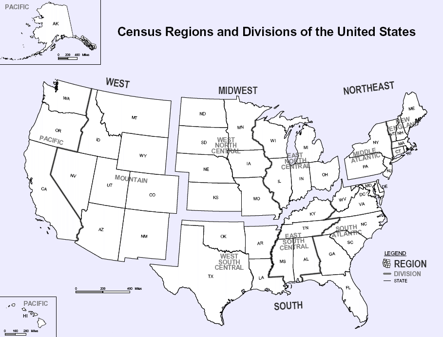
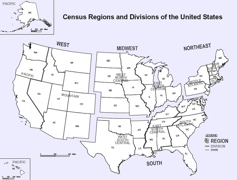
Map of U.S. Census Regions and Divisions. This map shows the four official US Census Regions, and the nine official Divisions within those Regions. See also: Image:US Census regional map.gif.
Potestas usoris
This work is in the public domain in the United States because it is a work prepared by an officer or employee of the United States Government as part of that person’s official duties under the terms of Title 17, Chapter 1, Section 105 of the US Code.
Note: This only applies to original works of the Federal Government and not to the work of any individual U.S. state, territory, commonwealth, county, municipality, or any other subdivision. This template also does not apply to postage stamp designs published by the United States Postal Service since 1978. (See § 313.6(C)(1) of Compendium of U.S. Copyright Office Practices). It also does not apply to certain US coins; see The US Mint Terms of Use.
|
 | |
| This file has been identified as being free of known restrictions under copyright law, including all related and neighboring rights. | ||

|
File:Census Regions and Division of the United States.svg is a vector version of this file. It should be used in place of this PNG file.
File:Census Regions and Divisions.PNG → File:Census Regions and Division of the United States.svg
For more information, see Help:SVG. |
 |
Historia fasciculi
Presso die vel tempore fasciculum videbis, sicut tunc temporis apparuit.
| Dies/Tempus | Minutio | Dimensiones | Usor | Sententia | |
|---|---|---|---|---|---|
| recentissima | 11:56, 9 Novembris 2023 | | 909 × 692 (92 chiliocteti) | Harold | Reverted to version as of 19:46, 13 June 2010 (UTC), COM:OW |
| 22:08, 3 Septembris 2020 |  | 2 200 × 1 700 (103 chiliocteti) | ACupOfCoffee | Census regions were changed in 2013. | |
| 19:46, 13 Iunii 2010 |  | 909 × 692 (92 chiliocteti) | Ras67 | cropped, wm removed | |
| 22:11, 29 Novembris 2006 |  | 916 × 699 (107 chiliocteti) | Electionworld | {{ew|en|NThurston}} Map of U.S. Census Regions and Divisions. == Licensing == {{PD-USGov}} Category:Maps of the United States |
Nexus ad fasciculum
Nullae paginae hoc fasciculo utuntur.
Usus fasciculi per inceptus Vicimediorum
Quae incepta Vici fasciculo utuntur:
- Usus in bn.wikipedia.org
- Usus in ca.wikipedia.org
- Usus in de.wikipedia.org
- Usus in en.wikipedia.org
- Usus in eo.wikipedia.org
- Usus in gl.wikipedia.org
- Usus in it.wikipedia.org
- Usus in ja.wikipedia.org
- Usus in ko.wikipedia.org
- Usus in nn.wikipedia.org
- Usus in ro.wikipedia.org
- Usus in simple.wikipedia.org
- Usus in sk.wikipedia.org
- Usus in tr.wikipedia.org
- Usus in vec.wikipedia.org
- Usus in vi.wikipedia.org