
Fasciculus:Carolinacolony.png
Mensura huius perspectionis: 572 × 599 elementa imaginalia. Aliae mensurae: 229 × 240 elementa imaginalia | 458 × 480 elementa imaginalia | 1 000 × 1 048 elementa imaginalia.
Sua resolutio (1 000 × 1 048 elementa imaginalia, magnitudo fasciculi: 419 chiliocteti, typus MIME: image/png)
Summarium

|
This historical map image could be re-created using vector graphics as an SVG file. This has several advantages; see Commons:Media for cleanup for more information. If an SVG form of this image is available, please upload it and afterwards replace this template with
{{vector version available|new image name}}.
It is recommended to name the SVG file “Carolinacolony.svg”—then the template Vector version available (or Vva) does not need the new image name parameter. |
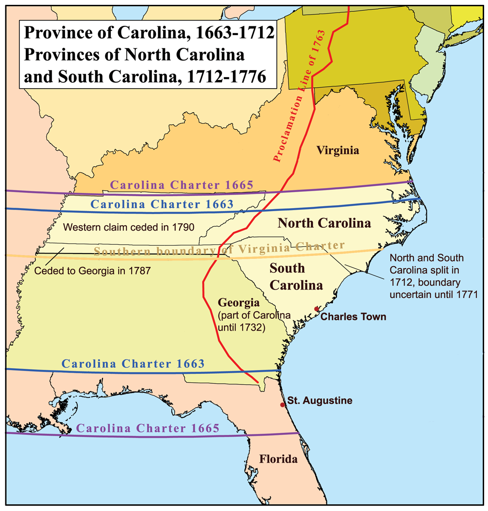
This is a map of the Province of Carolina that I made. Boundary disputes between colonies not involving Carolina are not shown.
Potestas usoris
I, the copyright holder of this work, hereby publish it under the following license:
This file is licensed under the Creative Commons Attribution-Share Alike 2.5 Generic license.
- Tibi licet:
- communicare – copiare, distribuere et committere hoc opus
- to remix – to adapt the work
- His condicionibus:
- attributio – You must give appropriate credit, provide a link to the license, and indicate if changes were made. You may do so in any reasonable manner, but not in any way that suggests the licensor endorses you or your use.
- aequa parte – If you remix, transform, or build upon the material, you must distribute your contributions under the same or compatible license as the original.
Historia fasciculi
Presso die vel tempore fasciculum videbis, sicut tunc temporis apparuit.
| Dies/Tempus | Minutio | Dimensiones | Usor | Sententia | |
|---|---|---|---|---|---|
| recentissima | 17:22, 21 Iunii 2013 | | 1 000 × 1 048 (419 chiliocteti) | Kmusser | 1729 corrected to 1712 |
| 21:32, 16 Novembris 2006 |  | 500 × 524 (96 chiliocteti) | Kmusser | This is a map of the Province of Carolina that I made. Boundary disputes between colonies not involving Carolina are not shown. == Licensing == {{self|cc-by-sa-2.5}} Category:Maps of disputed territories [[Category:Maps |
Nexus ad fasciculum
Ad hunc fasciculum nectit:
Usus fasciculi per inceptus Vicimediorum
Quae incepta Vici fasciculo utuntur:
- Usus in ar.wikipedia.org
- Usus in ca.wikipedia.org
- Usus in cs.wikipedia.org
- Usus in de.wikipedia.org
- Usus in en.wikipedia.org
- Usus in es.wikipedia.org
- Usus in fi.wikipedia.org
- Usus in fr.wikipedia.org
- Usus in fr.wiktionary.org
- Usus in he.wikipedia.org
- Usus in id.wikipedia.org
- Usus in it.wikipedia.org
- Usus in ja.wikipedia.org
- Usus in ko.wikipedia.org
- Usus in mt.wikipedia.org
- Usus in nl.wikipedia.org
- Usus in nn.wikipedia.org
- Usus in no.wikipedia.org
- Usus in oc.wikipedia.org
- Usus in pl.wikipedia.org
View more global usage of this file.