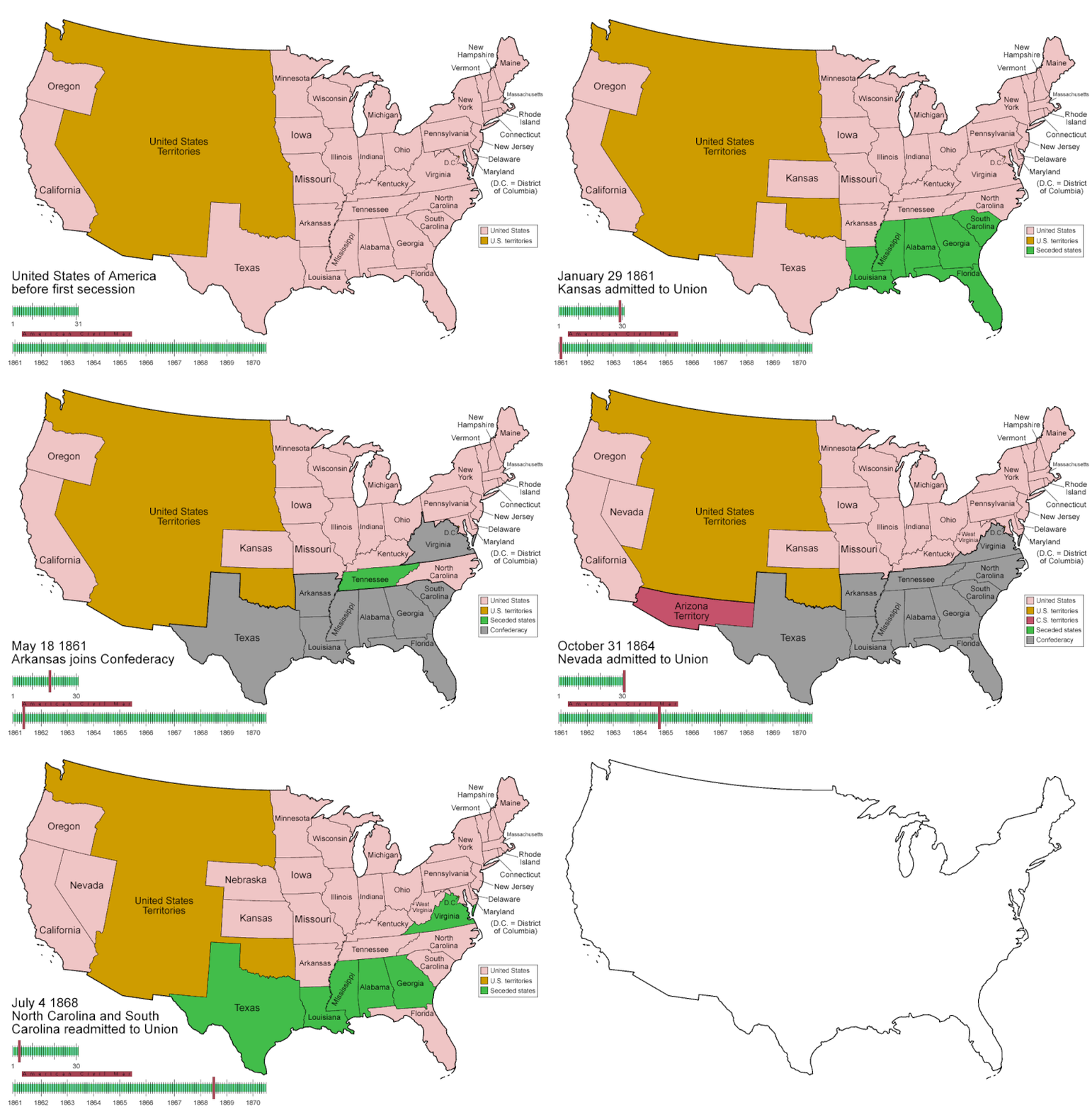
Fasciculus:CSA states evolution.gif

Mensura huius perspectionis: 800 × 542 elementa imaginalia. Aliae mensurae: 320 × 217 elementa imaginalia | 640 × 433 elementa imaginalia | 1 000 × 677 elementa imaginalia.
Sua resolutio (1 000 × 677 elementa imaginalia, magnitudo fasciculi: 245 chiliocteti, typus MIME: image/gif, looped, 38 repla, 1 min 53 s)
Historia fasciculi
Presso die vel tempore fasciculum videbis, sicut tunc temporis apparuit.
| Dies/Tempus | Minutio | Dimensiones | Usor | Sententia | |
|---|---|---|---|---|---|
| recentissima | 05:30, 5 Iunii 2014 |  | 1 000 × 677 (245 chiliocteti) | RedXIV | Removed incorrect information. Kentucky and Missouri never seceded. The state governments of Kentucky and Missouri never voted to secede. Claiming that their secession actually happened gives an inaccurate impression of the actual sequence of events. |
| 10:56, 21 Decembris 2013 |  | 1 000 × 677 (256 chiliocteti) | ChrisnHouston | I'm the one who broke the thumbnail. I'll try to fix it now... | |
| 13:38, 20 Decembris 2013 |  | 1 000 × 677 (1.75 megaocteti) | Afernand74 | No image displayed. Reupload to try to solve the problem | |
| 11:33, 7 Novembris 2013 |  | 1 000 × 677 (1.75 megaocteti) | ChrisnHouston | Adding a bar to the timeline to indicate when the actual fighting of the Civil War happened, which is one of the most important aspects of this map. | |
| 15:18, 11 Aprilis 2012 |  | 1 000 × 677 (254 chiliocteti) | Golbez | rv - er, MO and KY were indeed admitted to the CSA, though it lacked any control over them. why not go to the talk page for the CSA on enwp and chat about my next version? | |
| 18:53, 10 Aprilis 2012 |  | 1 000 × 677 (225 chiliocteti) | Travürsa | Fixed errors. | |
| 01:57, 18 Novembris 2007 |  | 1 000 × 677 (254 chiliocteti) | Golbez | Removing frame of WV counties; that was incorrect, they were always part of WV | |
| 09:54, 4 Martii 2007 |  | 1 000 × 677 (259 chiliocteti) | Golbez | == Summary == {{Information |Description=Animated map/timeline of the territorial evolution of the Confederate States of America, from first secession to end of Reconstruction. |Source=Self-made. |Date=March 2007 |Author=User:Golbez |Permission= see b |
Nexus ad fasciculum
Ad hunc fasciculum nectit:
Usus fasciculi per inceptus Vicimediorum
Quae incepta Vici fasciculo utuntur:
- Usus in af.wikipedia.org
- Usus in bcl.wikipedia.org
- Usus in cs.wikipedia.org
- Usus in da.wikipedia.org
- Usus in de.wikipedia.org
- Usus in en.wikipedia.org
- Confederate States of America
- Portal:United States/Selected picture
- User talk:-asx-
- User talk:Golbez/Archive 2
- Portal:Maps/Selected picture
- Wikipedia:Featured picture candidates/March-2007
- Wikipedia:Picture peer review/CSA evolution
- Wikipedia:Featured picture candidates/CSA states evolution.gif
- Wikipedia:Wikipedia Signpost/2007-03-20/Features and admins
- Wikipedia:Wikipedia Signpost/2007-03-20/SPV
- Portal:Maps/Selected picture/11
- Portal:United States/Selected picture/15
- Wikipedia:Featured picture candidates/November-2009
- Wikipedia:Featured picture candidates/Non-Native American Nations Control over N America 1750-2008.gif
- Wikipedia:Featured picture candidates/delist/2010
- Wikipedia:Featured picture candidates/delist/File:CSA states evolution.gif
- User:TheVirginiaHistorian/sandbox
- Wikipedia:Village pump (technical)/Archive 110
- Wikipedia:Wikipedia Signpost/Single/2007-03-20
- Usus in eo.wikipedia.org
- Usus in eu.wikipedia.org
- Usus in fr.wikipedia.org
- Usus in fr.wiktionary.org
- Usus in fy.wikipedia.org
- Usus in hr.wikipedia.org
- Usus in hu.wikipedia.org
- Usus in id.wikipedia.org
- Usus in ja.wikipedia.org
- Usus in ms.wikipedia.org
- Usus in pt.wikipedia.org
- Usus in ro.wikipedia.org
- Usus in sr.wikipedia.org
- Usus in th.wikipedia.org
- Usus in tr.wikipedia.org
- Usus in uk.wikipedia.org

