
Fasciculus:Polynesian triangle.svg

Size of this PNG preview of this SVG file: 600 × 600 elementa imaginalia. Aliae mensurae: 240 × 240 elementa imaginalia | 480 × 480 elementa imaginalia | 768 × 768 elementa imaginalia | 1 024 × 1 024 elementa imaginalia | 2 048 × 2 048 elementa imaginalia.
Sua resolutio (fasciculus SVG, nominale 600 × 600 elementa imaginalia, magnitudo fasciculi: 281 chiliocteti)
Summarium
| Descriptio |
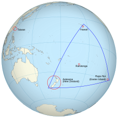
English: An orthographic projection of the pacific ocean, showing land outlines (resolution ~0.5 degrees) and the Polynesian triangle between Hawai'i, Rapa Nui and Aotearoa. Created using perlshaper to convert Natural Earth Data into an SVG file. Some tweaking was then done in Inkscape to fix up boundaries for countries on the edge of the projection. |
| Datum | |
| Fons | Opus proprium |
| Auctor | Gringer |
| Other versions | Macedonian version |
| SVG genesis |
Potestas usoris
I, the copyright holder of this work, hereby publish it under the following license:
This file is licensed under the Creative Commons Attribution 3.0 Unported license.
- Tibi licet:
- communicare – copiare, distribuere et committere hoc opus
- to remix – to adapt the work
- His condicionibus:
- attributio – You must give appropriate credit, provide a link to the license, and indicate if changes were made. You may do so in any reasonable manner, but not in any way that suggests the licensor endorses you or your use.
Historia fasciculi
Presso die vel tempore fasciculum videbis, sicut tunc temporis apparuit.
| Dies/Tempus | Minutio | Dimensiones | Usor | Sententia | |
|---|---|---|---|---|---|
| recentissima | 02:36, 16 Iunii 2013 | | 600 × 600 (281 chiliocteti) | AnonMoos | adjust margins |
| 11:34, 3 Septembris 2010 |  | 550 × 550 (290 chiliocteti) | Gringer | updated with [http://www.naturalearthdata.com Natural Earth Data] | |
| 03:01, 24 Novembris 2009 |  | 542 × 542 (90 chiliocteti) | Gringer | {{Information |Description={{en|1=An orthographic projection of the pacific ocean, showing land outlines (resolution ~0.5 degrees) and the Polynesian triangle between Hawai'i, Rapa Nui and Aotearoa. Created using a custom perl script (http://user.interfac |
Nexus ad fasciculum
Ad hunc fasciculum nectit:
Usus fasciculi per inceptus Vicimediorum
Quae incepta Vici fasciculo utuntur:
- Usus in af.wikipedia.org
- Usus in ca.wikipedia.org
- Usus in en.wikipedia.org
- Usus in es.wikipedia.org
- Usus in fi.wiktionary.org
- Usus in fr.wikipedia.org
- Usus in hi.wikipedia.org
- Usus in ia.wikipedia.org
- Usus in pl.wikipedia.org
- Usus in pt.wiktionary.org
- Usus in ru.wikipedia.org
- Usus in sr.wikipedia.org
- Usus in uk.wikipedia.org
- Usus in www.wikidata.org