
Fasciculus:Map of the Territory of the Corieltauvi.svg

Size of this PNG preview of this SVG file: 424 × 600 elementa imaginalia. Aliae mensurae: 170 × 240 elementa imaginalia | 339 × 480 elementa imaginalia | 543 × 768 elementa imaginalia | 724 × 1 024 elementa imaginalia | 1 448 × 2 048 elementa imaginalia | 744 × 1 052 elementa imaginalia.
Sua resolutio (fasciculus SVG, nominale 744 × 1 052 elementa imaginalia, magnitudo fasciculi: 148 chiliocteti)
| Descriptio |
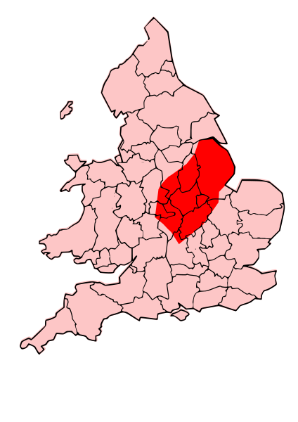
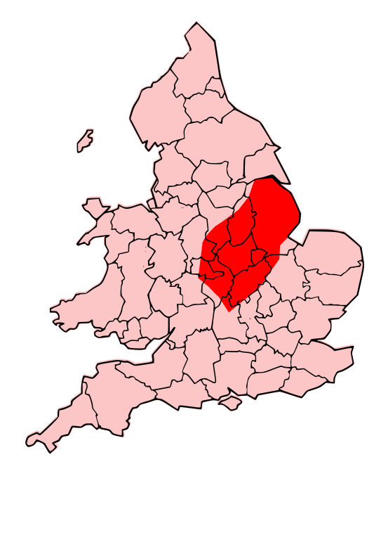
English: A map showing the territory of the Corieltauvi tribe overlayed in red in the context of the modern county boundaries of England and wales |
| Datum | (UTC) |
| Fons | |
| Auctor |
|
.svg)
.png)
| This is a retouched picture, which means that it has been digitally altered from its original version. Modifications: Revised to show territory of the Corieltauvi. The original can be viewed here: Map of the Territory of the Dobunni.svg:
|
I, the copyright holder of this work, hereby publish it under the following licenses:
This file is licensed under the Creative Commons Attribution-Share Alike 3.0 Unported license.
- Tibi licet:
- communicare – copiare, distribuere et committere hoc opus
- to remix – to adapt the work
- His condicionibus:
- attributio – You must give appropriate credit, provide a link to the license, and indicate if changes were made. You may do so in any reasonable manner, but not in any way that suggests the licensor endorses you or your use.
- aequa parte – If you remix, transform, or build upon the material, you must distribute your contributions under the same or compatible license as the original.

|
Licet hoc documentum exscribere vel distribuere vel demutare sub GNU Liberarum Litterarum Licentiae conditionibus in editione 1.2 aut in ulla editione recentiori a Fundatione Liberarum Programmationis Partium publicata; praeterquam Sectiones Immutabiles et Verba Involucra Adversa et Aversa. Licentiae exemplar praesto est in sectione intitulata GNU Free Documentation License. |
Tibi typum permissionis ligere licet.
Original upload log
This image is a derivative work of the following images:
- File:Map_of_the_Territory_of_the_Dobunni.svg licensed with Cc-by-sa-3.0, GFDL
- 2009-10-13T19:47:34Z Jpb1301 744x1052 (151192 Bytes) {{Information |Description={{en|1=A map showing the territory of the Dobunni tribe overlayed in red in the context of the modern county boundaries of England and wales}} |Source=*[[:File:Map_of_the_Territory_of_the_Dobunni.sv
- 2009-10-13T17:38:36Z Jpb1301 744x1052 (151194 Bytes) {{Information |Description={{en|1=A map showing the territory of the Dobunni tribe overlayed in red in the context of the modern county boundaries of England and wales}} |Source=*[[:File:Map_of_the_Territory_of_the_Cornovii_(
Uploaded with derivativeFX
Historia fasciculi
Presso die vel tempore fasciculum videbis, sicut tunc temporis apparuit.
| Dies/Tempus | Minutio | Dimensiones | Usor | Sententia | |
|---|---|---|---|---|---|
| recentissima | 21:33, 13 Octobris 2009 | | 744 × 1 052 (148 chiliocteti) | Jpb1301 | {{Information |Description={{en|1=A map showing the territory of the Corieltauvi tribe overlayed in red in the context of the modern county boundaries of England and wales}} |Source=*File:Map_of_the_Territory_of_the_Dobunni.svg |Date=2009-10-13 |
Nexus ad fasciculum
Ad hunc fasciculum nectit:
Usus fasciculi per inceptus Vicimediorum
Quae incepta Vici fasciculo utuntur:
- Usus in br.wikipedia.org
- Usus in ca.wikipedia.org
- Usus in cs.wikipedia.org
- Usus in cy.wikipedia.org
- Usus in en.wikipedia.org
- Usus in fr.wikipedia.org
- Usus in it.wikipedia.org
- Usus in pt.wikipedia.org
- Usus in ru.wikipedia.org
- Usus in uk.wikipedia.org