
Fasciculus:Map of Bengal.svg

Size of this PNG preview of this SVG file: 656 × 599 elementa imaginalia. Aliae mensurae: 263 × 240 elementa imaginalia | 526 × 480 elementa imaginalia | 841 × 768 elementa imaginalia | 1 121 × 1 024 elementa imaginalia | 2 242 × 2 048 elementa imaginalia | 1 835 × 1 676 elementa imaginalia.
Sua resolutio (fasciculus SVG, nominale 1 835 × 1 676 elementa imaginalia, magnitudo fasciculi: 1.32 megaocteti)
Summarium
| Descriptio |
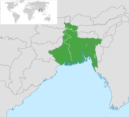
English: Map of Bengal. The region is today divided between East Bengal (Bangladesh) and West Bengal. Also showing the state of Tripura and the three districts of Cachar, Hailakandi and Karimganj; part of Barak Valley in Assam, India. Svenska: Karta av Bengal, delad mellan östra och västra. Staten Tripura och distrikten Hailakandi och Karimganj i södra Assam visas också. বাংলা: বাংলার মানচিত্র, পূর্ব ও পশ্চিমের মধ্যে বিভক্ত করা। মানচিত্রে চিহ্নিত রয়েছে বাংলাদেশের পূর্বে অবস্থিত বাংলাভাষী ভারতীয় রাজ্য ত্রিপুরা সহ আসাম রাজ্যের বরাক উপত্যকার তিনটি জেলা কাছাড়, হাইলাকান্দি এবং করিমগঞ্জ। |
| Datum | |
| Fons |
|
| Auctor | Goran tek-en |
| SVG genesis |

.svg)

Potestas usoris
This file is licensed under the Creative Commons Attribution-Share Alike 4.0 International license.
Attributio: Goran tek-en
- Tibi licet:
- communicare – copiare, distribuere et committere hoc opus
- to remix – to adapt the work
- His condicionibus:
- attributio – You must give appropriate credit, provide a link to the license, and indicate if changes were made. You may do so in any reasonable manner, but not in any way that suggests the licensor endorses you or your use.
- aequa parte – If you remix, transform, or build upon the material, you must distribute your contributions under the same or compatible license as the original.
Historia fasciculi
Presso die vel tempore fasciculum videbis, sicut tunc temporis apparuit.
| Dies/Tempus | Minutio | Dimensiones | Usor | Sententia | |
|---|---|---|---|---|---|
| recentissima | 10:03, 2 Novembris 2022 | | 1 835 × 1 676 (1.32 megaocteti) | MS Sakib | Reverted to version as of 18:02, 10 March 2022 (UTC) (tripura and barak area are included in bengal region!) |
| 05:28, 4 Octobris 2022 |  | 1 835 × 1 676 (1.31 megaocteti) | Msasag | Reverted to version as of 16:42, 4 October 2016 (UTC) | |
| 18:02, 10 Martii 2022 |  | 1 835 × 1 676 (1.32 megaocteti) | MS Sakib | Barak Valley area fixed | |
| 11:25, 12 Novembris 2017 |  | 1 835 × 1 676 (1.32 megaocteti) | Mouryan | =={{int:filedesc}}== {{Information |description={{en|1=Map of Bengal, divided between east and west.}}{{sv|1=Karta av Bengal, delad mellan östra och västra.}}{{bn|1=বাংলার মানচিত্র, পূর্ব ও পশ্চিম... | |
| 16:42, 4 Octobris 2016 |  | 1 835 × 1 676 (1.31 megaocteti) | BurritoBazooka | fix minimap bg turning up transparent in thumbnail? | |
| 16:40, 4 Octobris 2016 |  | 1 835 × 1 676 (1.31 megaocteti) | BurritoBazooka | paste File:BlankMap-World gray.svg in again for minimap, this time with Alaska and Lesotho. | |
| 17:13, 1 Decembris 2013 |  | 1 835 × 1 676 (1.19 megaocteti) | Goran tek-en | Enlarged map ~~~~ | |
| 17:53, 30 Novembris 2013 |  | 1 836 × 1 679 (1.2 megaocteti) | Goran tek-en | User created page with UploadWizard |
Nexus ad fasciculum
Ad hunc fasciculum nectit:
Usus fasciculi per inceptus Vicimediorum
Quae incepta Vici fasciculo utuntur:
- Usus in af.wikipedia.org
- Usus in ang.wikipedia.org
- Usus in ar.wikipedia.org
- Usus in ast.wikipedia.org
- Usus in as.wikipedia.org
- Usus in azb.wikipedia.org
- Usus in az.wikipedia.org
- Usus in az.wikiquote.org
- Usus in be.wikipedia.org
- Usus in bg.wikipedia.org
- Usus in bn.wikipedia.org
- টেমপ্লেট:ব্যবহারকারী/বাঙালি
- বঙ্গ
- ব্যবহারকারী:Snthakur
- ব্যবহারকারী:Wiki naogaon
- বঙ্গভঙ্গ (১৯৪৭)
- ব্যবহারকারী:Ali Haidar Khan
- ব্যবহারকারী:Tanveer.nonstop
- ব্যবহারকারী:Faysal
- ব্যবহারকারী:Jonoikobangali
- ব্যবহারকারী:Jayantanth/Userboxes
- ব্যবহারকারী:Yahia.barie
- ব্যবহারকারী:Tarunno
- ব্যবহারকারী:Ikfaisal
- প্রবেশদ্বার:বাংলাদেশ
- ব্যবহারকারী:Pasaban
- ব্যবহারকারী:Wildscop
- ব্যবহারকারী:Rezowan
- ব্যবহারকারী:ছেঁড়াবাকল
- ব্যবহারকারী:DesiNinja
- ব্যবহারকারী:Hemayet
- ব্যবহারকারী:Hemayetfaridpur
- ব্যবহারকারী:004satcho
- ব্যবহারকারী:Babaidmun
- ব্যবহারকারী:Bodhisattwa
- ব্যবহারকারী:Akramul Hoque Samim
- ব্যবহারকারী:শাহনেওয়াজ শুভ
- ব্যবহারকারী:Muhammad Tasbir Iftekhar
- ব্যবহারকারী:Mohd. Toukir Hamid
- ব্যবহারকারী:ইউক্লিড রনি
- ব্যবহারকারী:Sukanta Sarkar
- ব্যবহারকারী:Ashiq Shawon
- ব্যবহারকারী:Asaduzzamana
- ব্যবহারকারী:Akash Islam
- ব্যবহারকারী:Sabarni sarker
- ব্যবহারকারী:হাসান মাহমুদ
- ব্যবহারকারী:Md.Faysal Alam Riyad
View more global usage of this file.