
Fasciculus:Israel adm location map.svg

Sua resolutio (fasciculus SVG, nominale 614 × 1 141 elementa imaginalia, magnitudo fasciculi: 124 chiliocteti)
Summarium
| Descriptio |
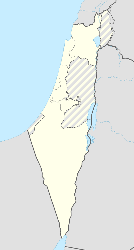
Deutsch: Positionskarte von Israel
English: Location map of Israel
|
||||||||||||
| Datum | |||||||||||||
| Fons |
Own work using:
|
||||||||||||
| Auctor | NordNordWest | ||||||||||||
| SVG genesis | This map was created with Adobe Illustrator.
|
||||||||||||

Potestas usoris
Usage of this file with:

explanatory notes: Legally binding is only the full legalcode. For a free usage I recommend to respect the following licence conditions:
1. Provide my name as given above: NordNordWest,
2. a copy of, or the URI for, the applicable license: https://creativecommons.org/licenses/by-sa/3.0/de/legalcode,
3. the title of the work,
4. in the case of an adaptation, a credit identifying the use of the work in the adaptation.
This license and the rights granted hereunder will terminate automatically upon any breach by you of the terms of this license. Any of the above conditions can be waived if you get permission from the copyright holder. If you have questions or wish differing conditions, please contact me through nnwest or my discussion page ![]() t-online.de
t-online.de
- Tibi licet:
- communicare – copiare, distribuere et committere hoc opus
- to remix – to adapt the work
- His condicionibus:
- attributio – You must give appropriate credit, provide a link to the license, and indicate if changes were made. You may do so in any reasonable manner, but not in any way that suggests the licensor endorses you or your use.
- aequa parte – If you remix, transform, or build upon the material, you must distribute your contributions under the same or compatible license as the original.

Historia fasciculi
Presso die vel tempore fasciculum videbis, sicut tunc temporis apparuit.
| Dies/Tempus | Minutio | Dimensiones | Usor | Sententia | |
|---|---|---|---|---|---|
| recentissima | 08:27, 19 Septembris 2016 | | 614 × 1 141 (124 chiliocteti) | NordNordWest | Reverted to version as of 18:01, 18 September 2016 (UTC); AGAIN: upload your version as a new file please |
| 20:23, 18 Septembris 2016 |  | 461 × 856 (80 chiliocteti) | Salvabl | Highest quality, with the Israeli territories in the West Bank (Area C) | |
| 20:17, 18 Septembris 2016 |  | 614 × 1 141 (124 chiliocteti) | Salvabl | Reverted to version as of 18:01, 18 September 2016 (UTC) | |
| 19:28, 18 Septembris 2016 |  | 614 × 1 141 (186 chiliocteti) | Salvabl | Reverted to version as of 17:40, 18 September 2016 (UTC) | |
| 18:01, 18 Septembris 2016 |  | 614 × 1 141 (124 chiliocteti) | NordNordWest | Reverted to version as of 17:12, 25 October 2015 (UTC), upload your version as a new file please | |
| 17:40, 18 Septembris 2016 |  | 614 × 1 141 (186 chiliocteti) | Salvabl | Added the Area C (Israeli territories in the West Bank) | |
| 17:12, 25 Octobris 2015 |  | 614 × 1 141 (124 chiliocteti) | NordNordWest | more exact Jerusalem boundary | |
| 17:29, 9 Septembris 2014 |  | 614 × 1 141 (123 chiliocteti) | NordNordWest | == {{int:filedesc}} == {{Information |Description= {{de|1=Positionskarte von Israel}} {{en|1=Location map of Israel}} {{Location map series N |top=33.5 |bottom=29.3 |left=33.7 |right=36.3 }} |Source={{Own using}} * United States National Imagery and Ma... |
Nexus ad fasciculum
Ad hunc fasciculum nectit:
Usus fasciculi per inceptus Vicimediorum
Quae incepta Vici fasciculo utuntur:
- Usus in de.wikipedia.org
- Jerusalem
- Tel Aviv-Jaffa
- Haifa
- Akkon
- Nazareth
- Cholon
- Bet Guvrin
- En Hod
- Zichron Jaʿakov
- Nachscholim
- Dan (Kibbuz)
- Jokne’am
- Karmi’el
- Maʿalot-Tarschiha
- Kirjat Tiw’on
- Kirjat Schmona
- Migdal haEmek
- Kirjat Mal’achi
- Tiberias
- Degania
- Afula
- En Gedi
- En Dor
- Jotvata
- Aschkelon
- Jad Mordechai
- Chadera
- Lochamej haGeta’ot
- Tabgha
- Ginnossar
- Eilat
- Schawe Zion
- Jagur
- Netanja
- Naharija
- Kfar Saba
- Rosch haNikra
- Benutzer Diskussion:Leshonai
- Maʿagan Micha’el
- Sderot
- Jerocham
- Palmachim
- Rischon LeZion
- Kabul (Israel)
- Nahalal
- Bet Schemesch
- Lod
- Be’er Scheva
- Sdot Jam
- Safed
View more global usage of this file.