Fasciculus:Gibraltar map-en.svg
Page contents not supported in other languages.
E Vicipaedia

Sua resolutio(fasciculus SVG, nominale 2 020 × 3 140 elementa imaginalia, magnitudo fasciculi: 289 chiliocteti)

Hic fasciculus apud Vicimedia Communia iacet; in aliis inceptis adhiberi potest. Contenta paginae descriptionis fasciculi subter monstrantur.

Imago (militia) of the year
Featured Imago (militia)

Vicimedia Communia

This file was a candidate in Picture of the Year 2007.
This is a featured picture on Wikimedia Commons (Featured pictures) and is considered one of the finest images. See its nomination here.

If you have an image of similar quality that can be published under a suitable copyright license, be sure to upload it, tag it, and nominate it.

Summarium

Camera location36° 08′ 00″ N, 5° 21′ 00″ W Kartographer map based on OpenStreetMap.View this and other nearby images on: OpenStreetMapinfo
Descriptio
Čeština: Mapa ostrova Gibraltar v angličtině.
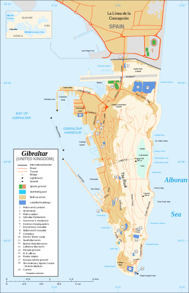
English: Map in English of Gibraltar.
Français : * Sujet : Carte en anglais de Gibraltar ;
  • Sources : Création personnelle ;
  • Carte créée à partir de captures d'écran d'images satellite de Google Earth d'un point de vue placé à 1,18 km d'altitude (imagerie disponible de novembre 2007) ;
  • Références complémentaires :
  • Échelle approximative : 1:40 000 (précision : environ 10 m) ;
  • Note : Largeur du tracé des routes proportionnelle à la réalité ;
  • Auteur : Eric Gaba (fr:Sting) ;
  • Date : Novembre 2007.
Português: Mapa (em Inglês) de Gibraltar.
Datum
Fons Own work ;
Map created using screenshots of Google Earth satellite imagery from a point of view located at 1.18 km of altitude (available imagery of November 2007) ;
Other references :
* CIA map ;
* Gibnet map ;
* U.K. MoD map
Locator map : Image:Blank_map_of_South_Europe_and_North_Africa.svg (modified) created by Historicair ;
Approximate scale : 1:40,000 (accuracy : about 10 m)
Note : The roads width is proportional to reality
Auctor Eric Gaba (Sting)
Permissio
(Reusing this file)
Attribution and Share-Alike required
Other versions

[recensere]

Disputed isthmus and land
SVG genesis
InfoField
 
The SVG code is valid.
 
This map was created with Inkscape…important.
 
 This map uses embedded text that can be easily translated using a text editor.

Potestas usoris

I, the copyright holder of this work, hereby publish it under the following licenses:
GNU head Licet hoc documentum exscribere vel distribuere vel demutare sub GNU Liberarum Litterarum Licentiae conditionibus in editione 1.2 aut in ulla editione recentiori a Fundatione Liberarum Programmationis Partium publicata; praeterquam Sectiones Immutabiles et Verba Involucra Adversa et Aversa. Licentiae exemplar praesto est in sectione intitulata GNU Free Documentation License.
w:en:Creative Commons
attributio aequa parte
This file is licensed under the Creative Commons Attribution-Share Alike Attribution-Share Alike 4.0 International, 3.0 Unported, 2.5 Generic, 2.0 Generic and 1.0 Generic license.
Tibi licet:
  • communicare – copiare, distribuere et committere hoc opus
  • to remix – to adapt the work
His condicionibus:
  • attributio – You must give appropriate credit, provide a link to the license, and indicate if changes were made. You may do so in any reasonable manner, but not in any way that suggests the licensor endorses you or your use.
  • aequa parte – If you remix, transform, or build upon the material, you must distribute your contributions under the same or compatible license as the original.
Tibi typum permissionis ligere licet.

Captions

Add a one-line explanation of what this file represents

Items portrayed in this file

depicts Anglica

copyrighted Anglica

November 2007

36°7'59.999"N, 5°21'0.000"W

media type Anglica

image/svg+xml

Historia fasciculi

Presso die vel tempore fasciculum videbis, sicut tunc temporis apparuit.

Dies/TempusMinutioDimensionesUsorSententia
recentissima20:10, 21 Februarii 2020Minutum speculum redactionis 20:10, 21 Februarii 2020 factae2 020 × 3 140 (289 chiliocteti)JoKalliauermalformed svg (compare firefox/chrome rendering with librsvg-rendering) actually firefox/chrome were correct, also it looks wrong
06:01, 29 Iunii 2017Minutum speculum redactionis 06:01, 29 Iunii 2017 factae2 020 × 3 140 (538 chiliocteti)Wereldburger758Removal error in file. Valid SVG now.
21:52, 27 Augusti 2008Minutum speculum redactionis 21:52, 27 Augusti 2008 factae2 020 × 3 140 (569 chiliocteti)RedCoatRemove "claimed by Spain", completely gratuitous for a map
11:28, 11 Decembris 2007Minutum speculum redactionis 11:28, 11 Decembris 2007 factae2 020 × 3 140 (570 chiliocteti)StingNotification of the Spanish claims
14:40, 27 Novembris 2007Minutum speculum redactionis 14:40, 27 Novembris 2007 factae2 020 × 3 140 (569 chiliocteti)StingAdditional names ; up-to-date corrections
21:35, 26 Novembris 2007Minutum speculum redactionis 21:35, 26 Novembris 2007 factae2 020 × 3 140 (561 chiliocteti)RedCoatHouse of Assembly → Gibraltar Parliament
19:51, 26 Novembris 2007Minutum speculum redactionis 19:51, 26 Novembris 2007 factae2 020 × 3 140 (561 chiliocteti)Sting+ info
14:12, 26 Novembris 2007Minutum speculum redactionis 14:12, 26 Novembris 2007 factae2 020 × 3 140 (561 chiliocteti)Sting+ info
13:21, 26 Novembris 2007Minutum speculum redactionis 13:21, 26 Novembris 2007 factae2 020 × 3 140 (561 chiliocteti)Sting{{Information |Description=Map in English of Gibraltar |Source=Own work ;<br/>Map created using screenshots of Google Earth satellite imagery from a point of view located at 1.18 km of altitude (available image

Ad hunc fasciculum nectit:

Usus fasciculi per inceptus Vicimediorum

Quae incepta Vici fasciculo utuntur:

Metadata