
Fasciculus:Wembley Stadium map.png

Mensura huius perspectionis: 774 × 599 elementa imaginalia. Aliae mensurae: 310 × 240 elementa imaginalia | 620 × 480 elementa imaginalia | 992 × 768 elementa imaginalia | 1 232 × 954 elementa imaginalia.
Sua resolutio (1 232 × 954 elementa imaginalia, magnitudo fasciculi: 948 chiliocteti, typus MIME: image/png)
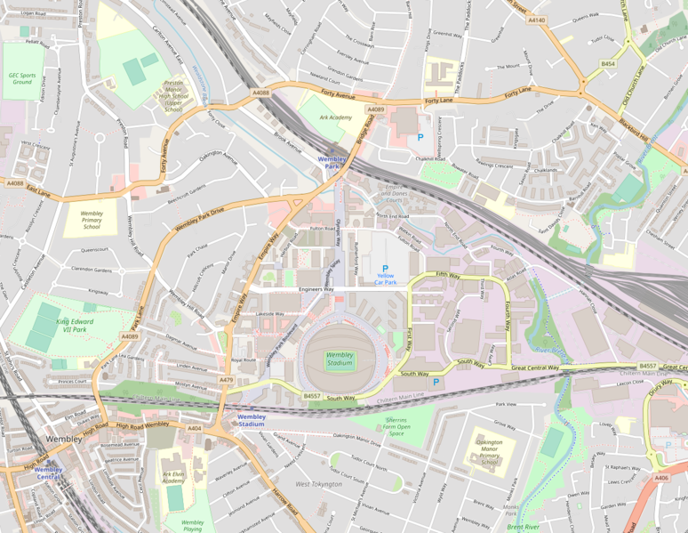
English: A map of England's Wembley Stadium in North West London, in relation to Olympic Way, Wembley Park/Central/Stadium stations, and the A406 (North Circular) Road (bottom right)
| Description |
This map was created from OpenStreetMap project data, collected by the community. This map may be incomplete, and may contain errors. Don't rely solely on it for navigation. |
| Datum | 19 May 2010 |
| Fons | openstreetmap.org |
| Auctor |
OpenStreetMap contributors |
| Permissio (Reusing this file) |
OpenStreetMap data and maps are licensed under the Creative Commons Attribution-ShareAlike 2.0 license (CC-BY-SA 2.0). This file is licensed under the Creative Commons Attribution-Share Alike 2.0 Generic license.
|
| Georeferencing | If inappropriate please set warp_status = skip to hide. |
Historia fasciculi
Presso die vel tempore fasciculum videbis, sicut tunc temporis apparuit.
| Dies/Tempus | Minutio | Dimensiones | Usor | Sententia | |
|---|---|---|---|---|---|
| recentissima | 20:10, 26 Iulii 2021 | | 1 232 × 954 (948 chiliocteti) | Boothy m | Updated map to July 2021 version of OpenStreetMap's standard layer, exported from https://www.openstreetmap.org/#map=15/51.5593/-0.2813 |
| 13:45, 19 Maii 2010 |  | 1 141 × 867 (497 chiliocteti) | Ultra7 | {{en|A map of England's {{w|Wembley Stadium}} in North West London, in relation to Olympic Way, Wembley Park/Central/Stadium stations, and the A406 (North Circular) Road (bottom right)}} {{OpenStreetMap|date=19 May 2010}} Category:Wembley Stadium |
Nexus ad fasciculum
Nullae paginae hoc fasciculo utuntur.
Usus fasciculi per inceptus Vicimediorum
Quae incepta Vici fasciculo utuntur:
- Usus in af.wikipedia.org
- Usus in az.wikipedia.org
- Usus in be.wikipedia.org
- Usus in bg.wikipedia.org
- Usus in bn.wikipedia.org
- Usus in ca.wikipedia.org
- Usus in ckb.wikipedia.org
- Usus in cs.wikipedia.org
- Usus in el.wikipedia.org
- Usus in en.wikipedia.org
- Usus in et.wikipedia.org
- Usus in eu.wikipedia.org
- Usus in fr.wikipedia.org
- Usus in gl.wikipedia.org
- Usus in hi.wikipedia.org
- Usus in hr.wikipedia.org
- Usus in hu.wikipedia.org
- Usus in hy.wikipedia.org
- Usus in id.wikipedia.org
- Usus in it.wikipedia.org
- Usus in ja.wikipedia.org
- Usus in jv.wikipedia.org
- Usus in ka.wikipedia.org
- Usus in lt.wikipedia.org
- Usus in mn.wikipedia.org
- Usus in mr.wikipedia.org
- Usus in nl.wikipedia.org
- Usus in ro.wikipedia.org
- Usus in sk.wikipedia.org
- Usus in th.wikipedia.org
- Usus in tr.wikipedia.org
- Usus in vi.wikipedia.org
- Usus in xmf.wikipedia.org
- Usus in zh.wikipedia.org