
Fasciculus:Verbreitungsgebiet der Tataren.PNG
Mensura huius perspectionis: 800 × 285 elementa imaginalia. Aliae mensurae: 320 × 114 elementa imaginalia | 1 077 × 384 elementa imaginalia.
Sua resolutio (1 077 × 384 elementa imaginalia, magnitudo fasciculi: 13 chiliocteti, typus MIME: image/png)

|
This ethnographic map image could be re-created using vector graphics as an SVG file. This has several advantages; see Commons:Media for cleanup for more information. If an SVG form of this image is available, please upload it and afterwards replace this template with
{{vector version available|new image name}}.
It is recommended to name the SVG file “Verbreitungsgebiet der Tataren.svg”—then the template Vector version available (or Vva) does not need the new image name parameter. |
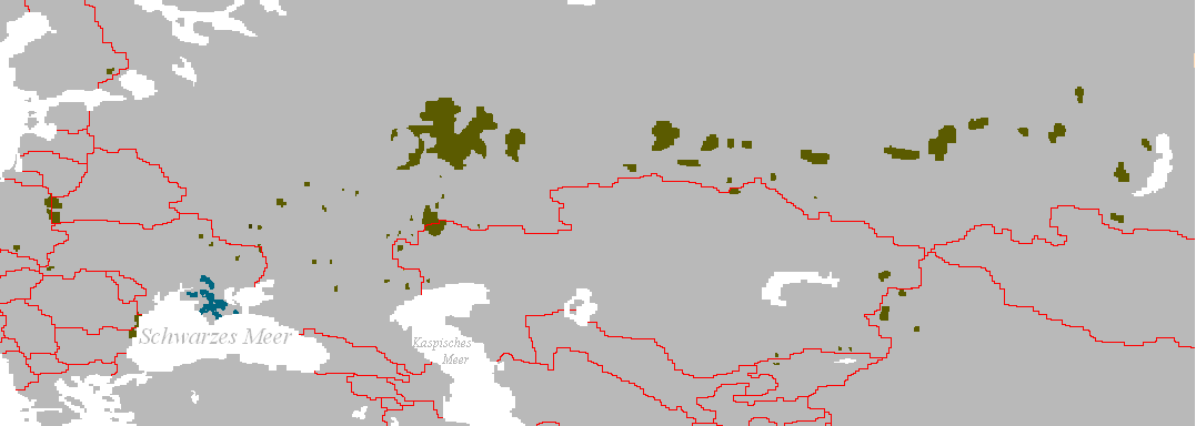
Verbreitungsgebiet der Turko-Tataren
- Beschreibung: Darstellungskarte mit den Siedlungsgebieten jener Völker, die sich heute als „Tataren“ bezeichnen bzw. sich von diesen herführen.
- Zeichner: Postmann Michael
- erstellt am: 13. Februar 2005
| |
This work has been released into the public domain by its author, Postmann Michael, at the Anglica Vicipaedia project. This applies worldwide. In case this is not legally possible: |
Historia fasciculi
Presso die vel tempore fasciculum videbis, sicut tunc temporis apparuit.
| Dies/Tempus | Minutio | Dimensiones | Usor | Sententia | |
|---|---|---|---|---|---|
| recentissima | 08:36, 10 Iulii 2017 | 1 077 × 384 (13 chiliocteti) | Szczureq | Restored Crimean Tatars, with different coloring. | |
| 20:52, 8 Novembris 2011 | 1 077 × 384 (25 chiliocteti) | Glossologist | Removed Crimean Tatars, which are a separate Turkic ethnic group. | ||
| 19:15, 8 Martii 2006 | 1 077 × 384 (22 chiliocteti) | Robert Weemeyer | Verbreitungsgebiet der Turko-Tataren * Beschreibung: Darstellungskarte mit den Siedlungsgebieten jener Völker, die sich heute als „Tataren“ bezeichen bzw. sich von diesen herführen. * Zeichner: Postmann Michael * erstellt am: 13. Februar 2005 {{PD |
Nexus ad fasciculum
Ad hunc fasciculum nectit:
Usus fasciculi per inceptus Vicimediorum
Quae incepta Vici fasciculo utuntur:
- Usus in af.wikipedia.org
- Usus in als.wikipedia.org
- Usus in an.wikipedia.org
- Usus in ast.wikipedia.org
- Usus in bg.wikipedia.org
- Usus in bs.wikipedia.org
- Usus in ca.wikipedia.org
- Usus in cs.wikipedia.org
- Usus in da.wikipedia.org
- Usus in de.wikipedia.org
- Usus in en.wikipedia.org
- Usus in eo.wikipedia.org
- Usus in fa.wikipedia.org
- Usus in frr.wikipedia.org
- Usus in fr.wikipedia.org
- Usus in fy.wikipedia.org
- Usus in ga.wikipedia.org
- Usus in gl.wikipedia.org
- Usus in got.wikipedia.org
- Usus in hr.wikipedia.org
- Usus in hr.wikiquote.org
- Usus in hu.wikipedia.org
- Usus in kaa.wikipedia.org
- Usus in lt.wikipedia.org
- Usus in lv.wikipedia.org
- Usus in mn.wikipedia.org
- Usus in nl.wikipedia.org
- Usus in oc.wikipedia.org
- Usus in olo.wikipedia.org
- Usus in pl.wikipedia.org
- Usus in ro.wikipedia.org
- Usus in sk.wikipedia.org
- Usus in stq.wikipedia.org
- Usus in su.wikipedia.org
- Usus in sv.wikipedia.org
- Usus in tk.wikipedia.org
- Usus in www.wikidata.org
View more global usage of this file.