
Fasciculus:US insular areas-B.png

Sua resolutio (1 482 × 624 elementa imaginalia, magnitudo fasciculi: 51 chiliocteti, typus MIME: image/png)

|
File:US insular areas SVG.svg is a vector version of this file. It should be used in place of this PNG file when not inferior.
File:US insular areas-B.png → File:US insular areas SVG.svg
For more information, see Help:SVG. |
 |
Summarium
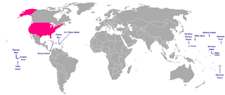
This is a map of the US Insular areas. The first version of this map was based off Image:BlankMap-World-v6.png by User:Astrokey44 with the locations of a few islands added; the source for this are two CIA maps; the maps are a map of the Pacific region and a map of the United States Pacific Island Wildlife Refuges. Hawaii has also been added to the map. Names of the islands are from the CIA Factbook. The second version is based off Image:Dependent_territories_2007.png by User:Sesmith.
For a version color-coded by each islands' status, see Image:US_insular_areas.png. For a version with the freely associated states, see Image:US_insular_areas-B FAS.png.
The previous map is under the GFDL; therefore, this map is too.
Potestas usoris

|
Licet hoc documentum exscribere vel distribuere vel demutare sub GNU Liberarum Litterarum Licentiae conditionibus in editione 1.2 aut in ulla editione recentiori a Fundatione Liberarum Programmationis Partium publicata; praeterquam Sectiones Immutabiles et Verba Involucra Adversa et Aversa. Licentiae exemplar praesto est in sectione intitulata GNU Free Documentation License. |
| This file is licensed under the Creative Commons Attribution-Share Alike 3.0 Unported license. | ||
| ||
| This licensing tag was added to this file as part of the GFDL licensing update. |
Historia fasciculi
Presso die vel tempore fasciculum videbis, sicut tunc temporis apparuit.
| Dies/Tempus | Minutio | Dimensiones | Usor | Sententia | |
|---|---|---|---|---|---|
| recentissima | 11:10, 9 Ianuarii 2008 | | 1 482 × 624 (51 chiliocteti) | Hoshie | rebuilt using User:Sesmith's maps; more to come. |
| 10:43, 17 Martii 2007 |  | 1 482 × 624 (32 chiliocteti) | Hoshie | This is a map of the US Insular areas. The base map is Image:BlankMap-World-v6.png by User:Astrokey44 with the locations of a few islands added; the source for this are two CIA maps; the maps are a [https://www.cia.gov/cia/publications/factbook/r |
Nexus ad fasciculum
Nullae paginae hoc fasciculo utuntur.
Usus fasciculi per inceptus Vicimediorum
Quae incepta Vici fasciculo utuntur:
- Usus in en.wikipedia.org
- Usus in kk.wikipedia.org