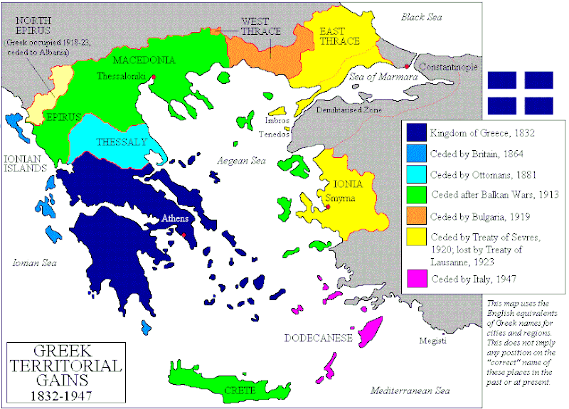
Fasciculus:Territorial Expansion of Greece from 1832–1947.gif

Mensura huius perspectionis: 800 × 575 elementa imaginalia. Aliae mensurae: 320 × 230 elementa imaginalia | 640 × 460 elementa imaginalia | 868 × 624 elementa imaginalia.
Sua resolutio (868 × 624 elementa imaginalia, magnitudo fasciculi: 49 chiliocteti, typus MIME: image/gif)
Historia fasciculi
Presso die vel tempore fasciculum videbis, sicut tunc temporis apparuit.
| Dies/Tempus | Minutio | Dimensiones | Usor | Sententia | |
|---|---|---|---|---|---|
| recentissima | 02:07, 3 Ianuarii 2014 |  | 868 × 624 (49 chiliocteti) | Spesh531 | update the year of Bulgarian losses, 1923 should be 1919 |
| 14:16, 15 Iulii 2013 |  | 868 × 624 (28 chiliocteti) | Spesh531 | adding Bulgarian losses | |
| 23:23, 18 Septembris 2011 |  | 868 × 624 (30 chiliocteti) | Vasarchit | corrected Epirus borderline | |
| 10:41, 19 Septembris 2008 |  | 868 × 624 (30 chiliocteti) | Peeperman | {{Information |Description= |Source= |Date= |Author= |Permission= |other_versions= }} | |
| 09:50, 15 Octobris 2006 |  | 868 × 624 (29 chiliocteti) | Christophe cagé | ||
| 09:49, 15 Octobris 2006 |  | 868 × 624 (29 chiliocteti) | Christophe cagé | == Summary == Map created by User:Adam Carr, August 2006 - imported from en:wikipedia by ~~~~ == Licensing == {{GFDL-self}} Category:Maps of the history of Greece |
Nexus ad fasciculum
Ad hunc fasciculum nectit:
Usus fasciculi per inceptus Vicimediorum
Quae incepta Vici fasciculo utuntur:
- Usus in az.wikipedia.org
- Usus in be-tarask.wikipedia.org
- Usus in be.wikipedia.org
- Usus in bg.wikipedia.org
- Usus in br.wikipedia.org
- Usus in bs.wikipedia.org
- Usus in ca.wikipedia.org
- Usus in cv.wikipedia.org
- Usus in en.wikipedia.org
- History of modern Greece
- Macedonia (region)
- Enosis
- Treaty of Sèvres
- Greece–Turkey relations
- History of Greece
- Treaty of Constantinople (1832)
- Portal:Greece
- Talk:Megali Idea
- User talk:Maggas
- User:Adam Carr/My archive of original cartographic contributions
- User talk:Inawe
- Timeline of Eastern Orthodoxy in Greece (1821–1924)
- Greece–Turkey border
- User:Falcaorib
- Talk:Balkan Wars/Archive 1
- User:Biz/Greece-Turkey/background
- Greece–Ottoman Empire relations
- Portal:Greece/sandbox
- Usus in et.wikipedia.org
- Usus in fa.wikipedia.org
- Usus in fi.wikipedia.org
- Usus in hy.wikipedia.org
- Usus in io.wikipedia.org
- Usus in ka.wikipedia.org
- Usus in ko.wikipedia.org
- Usus in ku.wikipedia.org
- Usus in lt.wikipedia.org
- Usus in lv.wikipedia.org
View more global usage of this file.


