
Fasciculus:Sweden Västra Götaland location map.svg

Size of this PNG preview of this SVG file: 564 × 600 elementa imaginalia. Aliae mensurae: 226 × 240 elementa imaginalia | 451 × 480 elementa imaginalia | 722 × 768 elementa imaginalia | 963 × 1 024 elementa imaginalia | 1 925 × 2 048 elementa imaginalia | 940 × 1 000 elementa imaginalia.
Sua resolutio (fasciculus SVG, nominale 940 × 1 000 elementa imaginalia, magnitudo fasciculi: 255 chiliocteti)
Summarium
| Descriptio |
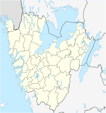
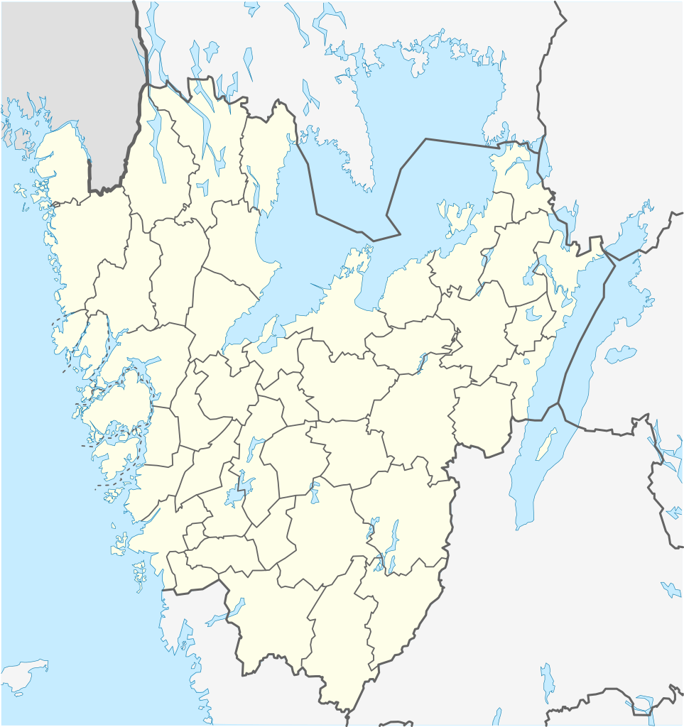
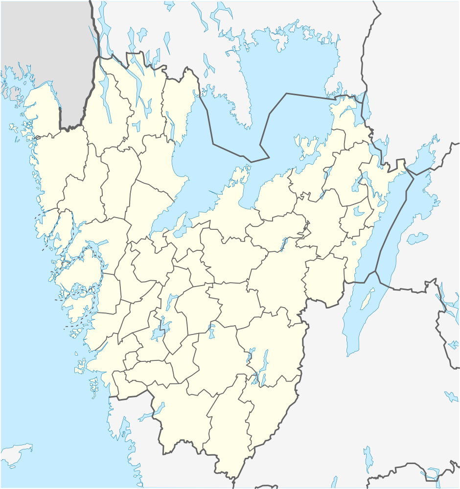
English: Location map of Västra Götaland in Sweden
Equirectangular projection, N/S stretching 190 %. Geographic limits of the map:
Deutsch: Positionskarte von Västra Götaland in Schweden
Quadratische Plattkarte, N-S-Streckung 190 %. Geographische Begrenzung der Karte:
Svenska: Karta över Västra Götaland i Sverige
Equirectangular projection, N / S sträcker sig 190%. Geografiska gränser för kartan:
|
| Datum | |
| Fons | Opus proprium |
| Auctor | Erik Frohne |
Potestas usoris
I, the copyright holder of this work, hereby publish it under the following licenses:

|
Licet hoc documentum exscribere vel distribuere vel demutare sub GNU Liberarum Litterarum Licentiae conditionibus in editione 1.2 aut in ulla editione recentiori a Fundatione Liberarum Programmationis Partium publicata; praeterquam Sectiones Immutabiles et Verba Involucra Adversa et Aversa. Licentiae exemplar praesto est in sectione intitulata GNU Free Documentation License. |
This file is licensed under the Creative Commons Attribution 3.0 Unported license.
- Tibi licet:
- communicare – copiare, distribuere et committere hoc opus
- to remix – to adapt the work
- His condicionibus:
- attributio – You must give appropriate credit, provide a link to the license, and indicate if changes were made. You may do so in any reasonable manner, but not in any way that suggests the licensor endorses you or your use.
Tibi typum permissionis ligere licet.
Historia fasciculi
Presso die vel tempore fasciculum videbis, sicut tunc temporis apparuit.
| Dies/Tempus | Minutio | Dimensiones | Usor | Sententia | |
|---|---|---|---|---|---|
| recentissima | 12:37, 11 Decembris 2011 | | 940 × 1 000 (255 chiliocteti) | Esquilo | Added municipal border between Skövde and Tibro. |
| 08:55, 27 Ianuarii 2009 |  | 940 × 1 000 (254 chiliocteti) | Erik Frohne | Adjusted waterline | |
| 07:28, 22 Ianuarii 2009 |  | 940 × 1 000 (253 chiliocteti) | Erik Frohne | {{Information |Description={{en|1=Location map of Västra Götaland in Sweden Equirectangular projection, N/S stretching 190 %. Geographic limits of the map: * N: 59.50° N * S: 57.10° N * W: 10.90° E * E: 15.20° E }} {{de|1=Positionskarte von Västr |
Nexus ad fasciculum
Nullae paginae hoc fasciculo utuntur.
Usus fasciculi per inceptus Vicimediorum
Quae incepta Vici fasciculo utuntur:
- Usus in ar.wikipedia.org
- Usus in arz.wikipedia.org
- Usus in bg.wikipedia.org
- Гьотеборг
- Карлсбори
- Ю (град)
- Шьовде
- Бурос
- Тролхетан
- Юнгшиле
- Венершбори
- Удевала
- Алингсос
- Омол
- Бенгтсфорш
- Болебюгд
- Далшьофорш
- Фристад
- Сандаред
- Шьомаркен
- Вискафорш
- Ед
- Фалшьопинг
- Фериеланда
- Йотене
- Ювик
- Торшланда
- Стюршьо
- Гресторп
- Гулспонг
- Хува
- Хенон
- Херюнга
- Шина
- Кунгелв
- Марщранд
- Кунгсхамн
- Хунебостранд
- Смьоген
- Лерум
- Флуда
View more global usage of this file.