
Fasciculus:Sulawesi Topography.png

Mensura huius perspectionis: 649 × 600 elementa imaginalia. Aliae mensurae: 260 × 240 elementa imaginalia | 519 × 480 elementa imaginalia | 831 × 768 elementa imaginalia | 1 108 × 1 024 elementa imaginalia | 2 153 × 1 990 elementa imaginalia.
Sua resolutio (2 153 × 1 990 elementa imaginalia, magnitudo fasciculi: 1.71 megaocteti, typus MIME: image/png)
Summarium
| Descriptio |
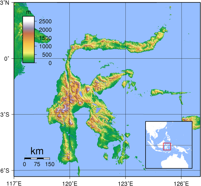
English: Relief (hypsometric) map of Sulawesi. Created with GMT from publicly released SRTM data. For locator version, see Image:Sulawesi_Locator_Topography.png
|
| Datum | |
| Fons | Opus proprium |
| Auctor | Sadalmelik |

|
This image has been assessed under the valued image criteria and is considered the most valued image on Commons within the scope: Hypsometric map of Sulawesi. You can see its nomination here. |
Potestas usoris
I, the copyright holder of this work, hereby publish it under the following licenses:

|
Licet hoc documentum exscribere vel distribuere vel demutare sub GNU Liberarum Litterarum Licentiae conditionibus in editione 1.2 aut in ulla editione recentiori a Fundatione Liberarum Programmationis Partium publicata; praeterquam Sectiones Immutabiles et Verba Involucra Adversa et Aversa. Licentiae exemplar praesto est in sectione intitulata GNU Free Documentation License. |
This file is licensed under the Creative Commons Attribution-Share Alike 3.0 Unported, 2.5 Generic, 2.0 Generic and 1.0 Generic license.
- Tibi licet:
- communicare – copiare, distribuere et committere hoc opus
- to remix – to adapt the work
- His condicionibus:
- attributio – You must give appropriate credit, provide a link to the license, and indicate if changes were made. You may do so in any reasonable manner, but not in any way that suggests the licensor endorses you or your use.
- aequa parte – If you remix, transform, or build upon the material, you must distribute your contributions under the same or compatible license as the original.
Tibi typum permissionis ligere licet.
Historia fasciculi
Presso die vel tempore fasciculum videbis, sicut tunc temporis apparuit.
| Dies/Tempus | Minutio | Dimensiones | Usor | Sententia | |
|---|---|---|---|---|---|
| recentissima | 18:11, 1 Septembris 2007 | | 2 153 × 1 990 (1.71 megaocteti) | Sadalmelik | {{Information |Description=Topographic map of Sulawesi. Created with GMT from publicly released SRTM data. For locator version, see Image:Sulawesi_Locator_Topography.png |Source=self-made |Date=Sep 1, 2007 |Author= Sadalmelik }} |
Nexus ad fasciculum
Ad hunc fasciculum nectit:
Usus fasciculi per inceptus Vicimediorum
Quae incepta Vici fasciculo utuntur:
- Usus in ace.wikipedia.org
- Usus in af.wikipedia.org
- Usus in ast.wikipedia.org
- Usus in ban.wikipedia.org
- Usus in ba.wikipedia.org
- Usus in be-tarask.wikipedia.org
- Usus in bg.wikipedia.org
- Usus in bn.wikipedia.org
- Usus in br.wikipedia.org
- Usus in ca.wikipedia.org
- Usus in cs.wikipedia.org
- Usus in cy.wikipedia.org
- Usus in de.wikipedia.org
- Usus in el.wikipedia.org
- Usus in en.wikipedia.org
- Usus in en.wikinews.org
- Usus in en.wikiversity.org
- Usus in eo.wikipedia.org
- Usus in es.wikipedia.org
- Usus in es.wiktionary.org
- Usus in et.wikipedia.org
- Usus in eu.wikipedia.org
- Usus in frr.wikipedia.org
- Usus in fr.wikipedia.org
- Usus in fr.wiktionary.org
- Usus in fy.wikipedia.org
- Usus in ga.wikipedia.org
- Usus in gd.wikipedia.org
- Usus in ha.wikipedia.org
- Usus in hu.wikipedia.org
- Usus in id.wikipedia.org
- Usus in ilo.wikipedia.org
- Usus in incubator.wikimedia.org
- Usus in is.wikipedia.org
- Usus in it.wikipedia.org
- Usus in ja.wikipedia.org
- Usus in ka.wikipedia.org
- Usus in km.wikipedia.org
- Usus in ko.wikipedia.org
View more global usage of this file.