
Fasciculus:Strait of Dover map.png

Mensura huius perspectionis: 798 × 599 elementa imaginalia. Aliae mensurae: 320 × 240 elementa imaginalia | 639 × 480 elementa imaginalia | 1 000 × 751 elementa imaginalia.
Sua resolutio (1 000 × 751 elementa imaginalia, magnitudo fasciculi: 187 chiliocteti, typus MIME: image/png)
Summarium
| Descriptio |
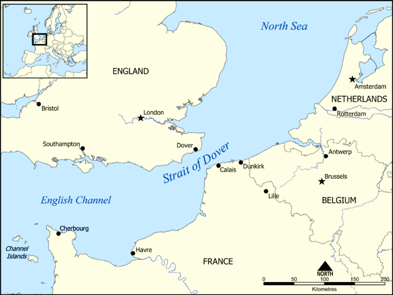
This map shows the location of the Strait of Dover between England and France, and part of the English Channel and the North Sea. It also shows nearby towns such as Dover, Calais, and Dunkirk. Created by NormanEinstein, December 15, 2005. |
| Datum | 15 December 2005 (original upload date) |
| Fons | No machine-readable source provided. Own work assumed (based on copyright claims). |
| Auctor | No machine-readable author provided. NormanEinstein assumed (based on copyright claims). |
Potestas usoris
I, the copyright holder of this work, hereby publish it under the following licenses:

|
Licet hoc documentum exscribere vel distribuere vel demutare sub GNU Liberarum Litterarum Licentiae conditionibus in editione 1.2 aut in ulla editione recentiori a Fundatione Liberarum Programmationis Partium publicata; praeterquam Sectiones Immutabiles et Verba Involucra Adversa et Aversa. Licentiae exemplar praesto est in sectione intitulata GNU Free Documentation License. |
| This file is licensed under the Creative Commons Attribution-Share Alike 3.0 Unported license. | ||
| ||
| This licensing tag was added to this file as part of the GFDL licensing update. |
Tibi typum permissionis ligere licet.
Derivative works
-
 hrvatski (SVG)
 -
 македонски (SVG)
 -
 English (PNG), showing evacuation routes of the Dunkirk evacuation


| Annotations | This image is annotated: View the annotations at Commons |
Historia fasciculi
Presso die vel tempore fasciculum videbis, sicut tunc temporis apparuit.
| Dies/Tempus | Minutio | Dimensiones | Usor | Sententia | |
|---|---|---|---|---|---|
| recentissima | 19:17, 13 Iunii 2014 | | 1 000 × 751 (187 chiliocteti) | Hohum | Adjust colours |
| 15:34, 15 Decembris 2005 |  | 1 000 × 751 (296 chiliocteti) | NormanEinstein | This map shows the location of the Strait of Dover between England and France, and part of the English Channel and the North Sea. It also shows nearby towns such as Dover, Calais, and Dunkirk. Created by NormanEinstein, December 15, 2005. {{GFDL-self}} |
Nexus ad fasciculum
Ad hunc fasciculum nectit:
Usus fasciculi per inceptus Vicimediorum
Quae incepta Vici fasciculo utuntur:
- Usus in af.wikipedia.org
- Usus in an.wikipedia.org
- Usus in ar.wikipedia.org
- Usus in ba.wikipedia.org
- Usus in be-tarask.wikipedia.org
- Usus in be.wikipedia.org
- Usus in bg.wikipedia.org
- Usus in bh.wikipedia.org
- Usus in bn.wikipedia.org
- Usus in br.wikipedia.org
- Usus in da.wikipedia.org
- Usus in de.wikipedia.org
- Usus in el.wikipedia.org
- Usus in en.wikipedia.org
- Usus in en.wikibooks.org
- Usus in fa.wikipedia.org
- Usus in fi.wikipedia.org
- Usus in fr.wikipedia.org
- Usus in fy.wikipedia.org
- Usus in gl.wikipedia.org
- Usus in hu.wikipedia.org
- Usus in id.wikipedia.org
- Usus in it.wikipedia.org
- Usus in ja.wikipedia.org
- Usus in mr.wikipedia.org
- Usus in ms.wikipedia.org
- Usus in nn.wikipedia.org
- Usus in no.wikipedia.org
- Usus in pt.wikipedia.org
- Usus in ro.wikipedia.org
- Usus in simple.wikipedia.org
- Usus in sl.wikipedia.org
View more global usage of this file.