
Fasciculus:Relief Map of Brazil.jpg

Mensura huius perspectionis: 607 × 600 elementa imaginalia. Aliae mensurae: 243 × 240 elementa imaginalia | 486 × 480 elementa imaginalia | 777 × 768 elementa imaginalia | 1 200 × 1 186 elementa imaginalia.
Sua resolutio (1 200 × 1 186 elementa imaginalia, magnitudo fasciculi: 1.05 megaocteti, typus MIME: image/jpeg)
| Descriptio |
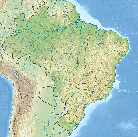
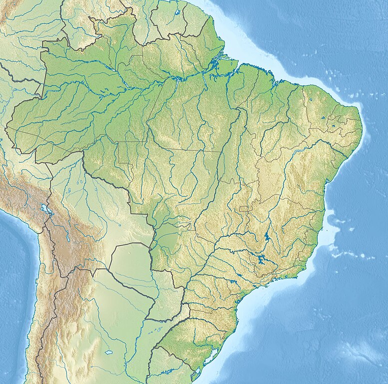
English: Location map of Brazil Equirectangular projection, N/S stretching 105 %. Geographic limits of the map:
|
|||
| Datum | (UTC) | |||
| Fons |
|
|||
| Auctor |
|
|||
| Other versions |
|


| This is a retouched picture, which means that it has been digitally altered from its original version. The original can be viewed here: Brazil location map.svg:
|
I, the copyright holder of this work, hereby publish it under the following license:
This file is licensed under the Creative Commons Attribution-Share Alike 3.0 Unported license.
- Tibi licet:
- communicare – copiare, distribuere et committere hoc opus
- to remix – to adapt the work
- His condicionibus:
- attributio – You must give appropriate credit, provide a link to the license, and indicate if changes were made. You may do so in any reasonable manner, but not in any way that suggests the licensor endorses you or your use.
- aequa parte – If you remix, transform, or build upon the material, you must distribute your contributions under the same or compatible license as the original.
Original upload log
This image is a derivative work of the following images:
- File:Brazil_location_map.svg licensed with Cc-by-sa-3.0
- 2009-08-05T19:53:55Z NordNordWest 2008x1984 (1674058 Bytes) {{int:filedesc}} {{Information |Description= {{de|Positionskarte von [[:de:Brasilien|Brasilien]]}} Quadratische Plattkarte, N-S-Streckung 105 %. Geographische Begrenzung der Karte: * N: 6.0° N * S: 34.0° S * W: 74.5° W * O
Uploaded with derivativeFX
Historia fasciculi
Presso die vel tempore fasciculum videbis, sicut tunc temporis apparuit.
| Dies/Tempus | Minutio | Dimensiones | Usor | Sententia | |
|---|---|---|---|---|---|
| recentissima | 21:46, 14 Maii 2017 | | 1 200 × 1 186 (1.05 megaocteti) | Janitoalevic | Added Rincón de Artigas disputed territory |
| 17:55, 27 Novembris 2010 |  | 1 200 × 1 186 (492 chiliocteti) | Виктор В | {{Information |Description={{en|Location map of Brazil}} Equirectangular projection, N/S stretching 105 %. Geographic limits of the map: * N: 6.0° N * S: 34.0° S * W: 74.5° W * E: 32.0° W |Source=*File:Brazil_location_map.svg |
Nexus ad fasciculum
Ad hunc fasciculum nectunt:
Usus fasciculi per inceptus Vicimediorum
Quae incepta Vici fasciculo utuntur:
- Usus in an.wikipedia.org
- Usus in ar.wikipedia.org
- Usus in ban.wikipedia.org
- Usus in bg.wikipedia.org
- Рио де Жанейро
- Итайпу
- Порто Алегри
- Сао Пауло
- Ирара
- Бауру
- Маже
- Айморес (Минаш Жерайс)
- Мост на дружбата (Парагвай - Бразилия)
- Бразилия (град)
- Петрополис
- Ресифи
- Флорианополис
- Анаполис
- Мадейра (река)
- Токантинс (река)
- Рио Негро (приток на Амазонка)
- Манаус
- Такуари
- Салвадор (Баия)
- Сантос
- Сао Бернардо до Кампо
- Розейра
- Ипатинга
- Трес Корасойнс
- Паулиста (Пернамбуко)
- Сао Висенти (Сао Пауло)
- Прадополис
- Белен (Пара)
- Бело Оризонти
- Масейо
- Форталеза
- Витория (Еспирито Санто)
- Гояния
- Кампо Гранди
- Кашоейра до Сул
- Итабуна
- Куритиба
- Арара (Параиба)
View more global usage of this file.