
Fasciculus:Relief Map of Armenia.png
Mensura huius perspectionis: 585 × 599 elementa imaginalia. Aliae mensurae: 234 × 240 elementa imaginalia | 469 × 480 elementa imaginalia | 1 000 × 1 024 elementa imaginalia.
Sua resolutio (1 000 × 1 024 elementa imaginalia, magnitudo fasciculi: 1.73 megaocteti, typus MIME: image/png)
Summarium
| Descriptio |
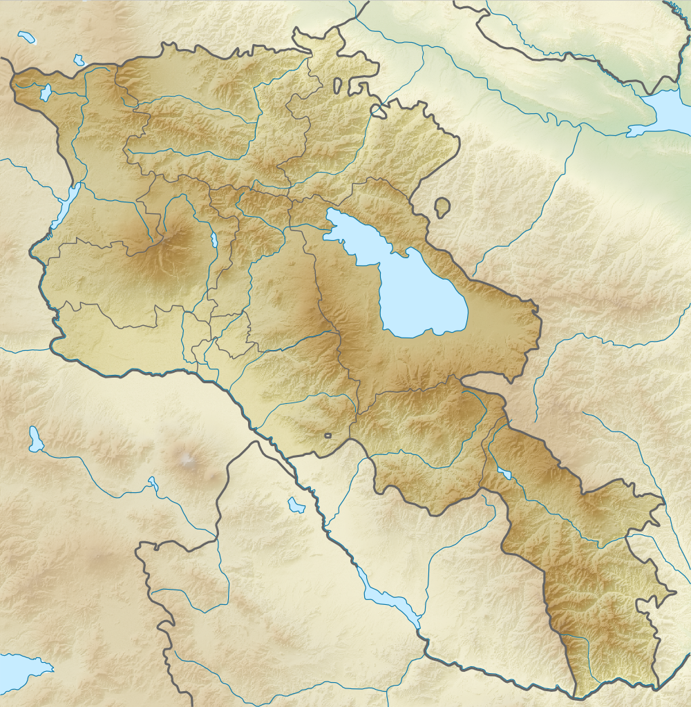
English: Relief map of Armenia. Equirectangular projection, N/S stretching 130 %. Geographic limits of the map:
Français : Carte topographique de l'Arménie. Projection cylindrique équidistante, avec étirement nord-sud de 130%.
|
| Datum | |
| Fons | |
| Auctor |
|
| Permissio (Reusing this file) |
This file is licensed under the Creative Commons Attribution-Share Alike 3.0 Unported license.
|
Historia fasciculi
Presso die vel tempore fasciculum videbis, sicut tunc temporis apparuit.
| Dies/Tempus | Minutio | Dimensiones | Usor | Sententia | |
|---|---|---|---|---|---|
| recentissima | 18:21, 22 Februarii 2014 | | 1 000 × 1 024 (1.73 megaocteti) | A2D2 | No unilateral changes. International borders are used. Please create additional svg map. |
| 09:21, 21 Februarii 2014 |  | 585 × 599 (654 chiliocteti) | Հայկ Ափրիկյան | Added Artsakh. | |
| 19:49, 5 Aprilis 2012 |  | 1 000 × 1 024 (1.73 megaocteti) | Sémhur | Adding few rivers : Dzoraget, Aghstafa, Azat, Vedi and Megri | |
| 19:36, 26 Augusti 2010 |  | 1 000 × 1 024 (1.73 megaocteti) | Виктор В | == {{int:filedesc}} == {{Information |Description={{en|Relief map of Armenia}} Equirectangular projection, N/S stretching 130 %. Geographic limits of the map: * N: 41.4° N * S: 38.8° N * W: 43.4° E * E: 46.7° E |Source=*[[:File:Armenia |
Nexus ad fasciculum
Ad hunc fasciculum nectunt:
Usus fasciculi per inceptus Vicimediorum
Quae incepta Vici fasciculo utuntur:
- Usus in ar.wikipedia.org
- Usus in ast.wikipedia.org
- Usus in av.wikipedia.org
- Usus in azb.wikipedia.org
- Usus in az.wikipedia.org
- Ağçala dağı
- Göyçə gölü
- Şablon:Yer xəritəsi Ermənistan
- Zəngiçay
- Alagöz dağı
- Loru çökəkliyi
- Ləlvar dağı
- Qazangöl (Ermənistan)
- Şəki şəlaləsi
- Dilijan Milli Parkı
- Göyçə yarımadası
- Ardanış yarımadası
- Goravan səhrası
- Tej-əhməd dağı
- Kari gölü
- Arpi gölü
- Şikahoğ Dövlət Təbiət Qoruğu
- Erebuni Dövlət Təbiət Qoruğu
- Mehri SES
- Göyçə-Zəngi kaskadı
- İrəvan Dəmiryol Stansiyası
- Gümrü Dəmiryol Stansiyası
- Xosrov Dövlət Təbiət Qoruğu
- Göyçə Milli Parkı
- İrəvan Botanika Bağı
- Ağrı vadisi
- Şərqi Göyçə silsiləsi
- Nərədüz burnu
- Balıqlı (göl)
- Apaklu
- Qarnıyarıq dağı
- Bərgüşad kaskadı
- Bərgüşad silsiləsi
- Qılıncdağ
- Abaran (yaylaq)
- Ajdaak vulkanı
- Geğam silsiləsi
- Qanlı göl (Göyçə)
- Axuryan su anbarı
- Lecan dağı
- Gərni dərəsi
- İrəvan zəlzələsi (1679)
- Usus in ba.wikipedia.org
View more global usage of this file.