
Fasciculus:Proportional circle Turkey city town population map 2012.png
Mensura huius perspectionis: 800 × 391 elementa imaginalia. Aliae mensurae: 320 × 156 elementa imaginalia | 640 × 313 elementa imaginalia | 1 024 × 500 elementa imaginalia | 1 280 × 626 elementa imaginalia | 3 552 × 1 736 elementa imaginalia.
Sua resolutio (3 552 × 1 736 elementa imaginalia, magnitudo fasciculi: 256 chiliocteti, typus MIME: image/png)
Summarium
| Descriptio |
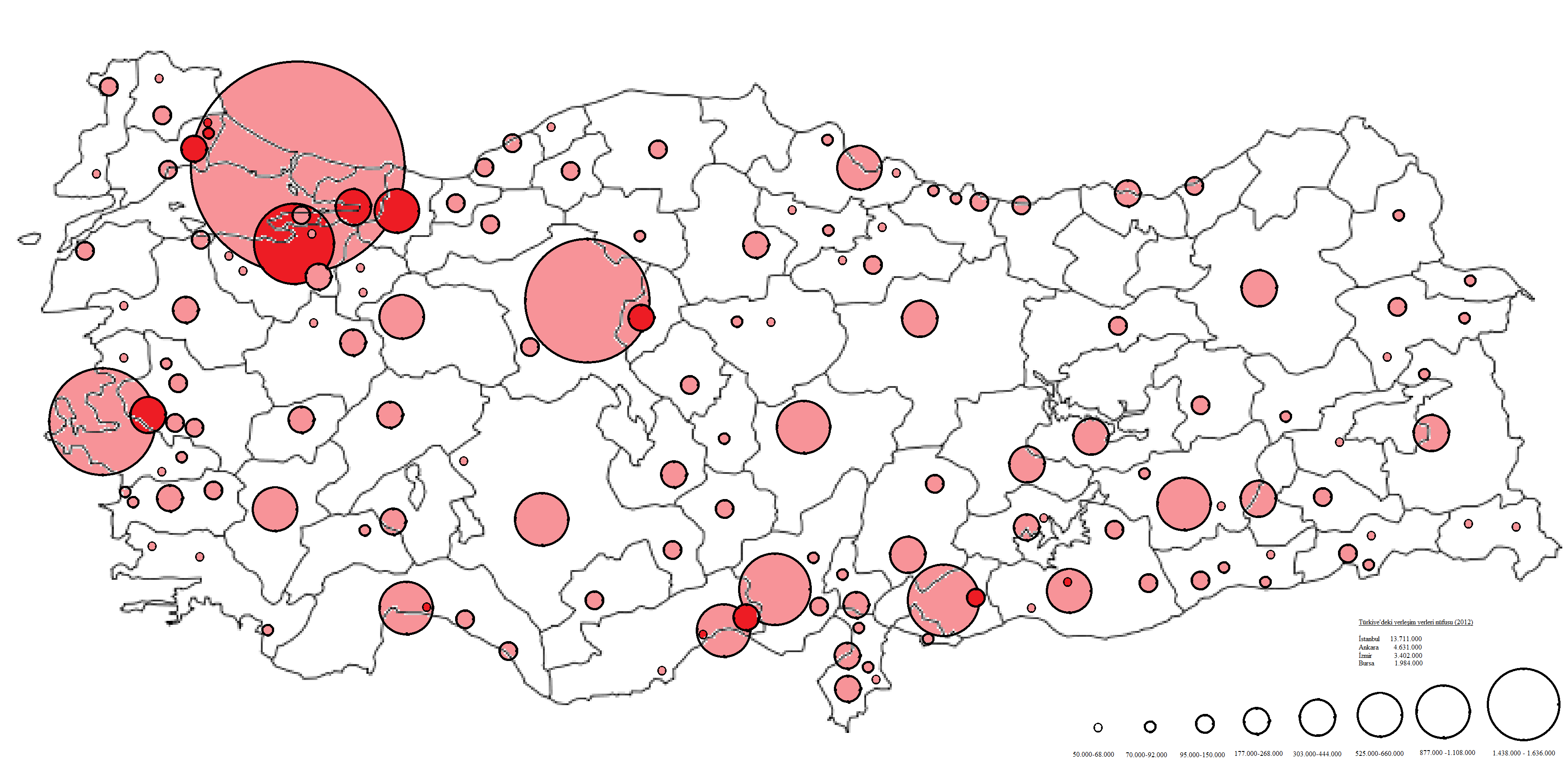
English: Proportional circle map of the population of towns and cities in Turkey in 2012.
Based on: [1] Türkçe: 2012 yılında Türkiye'de kasaba ve şehirlerin nüfusunun orantılı daire haritası.
Kaynak: [2] |
| Datum | |
| Fons | Opus proprium |
| Auctor | Bakayna |
Potestas usoris
I, the copyright holder of this work, hereby publish it under the following license:
This file is licensed under the Creative Commons Attribution-Share Alike 3.0 Unported license.
- Tibi licet:
- communicare – copiare, distribuere et committere hoc opus
- to remix – to adapt the work
- His condicionibus:
- attributio – You must give appropriate credit, provide a link to the license, and indicate if changes were made. You may do so in any reasonable manner, but not in any way that suggests the licensor endorses you or your use.
- aequa parte – If you remix, transform, or build upon the material, you must distribute your contributions under the same or compatible license as the original.
| Annotations | This image is annotated: View the annotations at Commons |
Historia fasciculi
Presso die vel tempore fasciculum videbis, sicut tunc temporis apparuit.
| Dies/Tempus | Minutio | Dimensiones | Usor | Sententia | |
|---|---|---|---|---|---|
| recentissima | 20:10, 10 Ianuarii 2014 | | 3 552 × 1 736 (256 chiliocteti) | Bakayna | User created page with UploadWizard |
Nexus ad fasciculum
Ad hunc fasciculum nectit:
Usus fasciculi per inceptus Vicimediorum
Quae incepta Vici fasciculo utuntur:
- Usus in bg.wikipedia.org
- Usus in en.wikipedia.org
- Usus in hu.wikipedia.org
- Usus in hy.wikipedia.org
- Usus in ku.wikipedia.org
- Usus in ru.wikipedia.org
- Usus in sh.wikipedia.org
- Usus in tr.wikipedia.org
- Usus in uz.wikipedia.org