
Fasciculus:Prefecture of Illyricum map.png

Mensura huius perspectionis: 607 × 600 elementa imaginalia. Aliae mensurae: 243 × 240 elementa imaginalia | 486 × 480 elementa imaginalia | 778 × 768 elementa imaginalia | 1 054 × 1 041 elementa imaginalia.
Sua resolutio (1 054 × 1 041 elementa imaginalia, magnitudo fasciculi: 103 chiliocteti, typus MIME: image/png)
Summarium
| Descriptio |
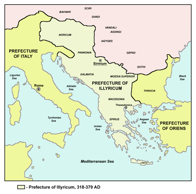
English: Historic map of Roman Praetorian Prefecture of Illyricum, 318-379 AD.
Српски / srpski: Istorijska karta rimske pretorijanske prefekture Ilirik, 318-379. godine.
Македонски: Историска карта на Римската преториска префектура Илирикум, во периодот од 318-379 година. |
| Datum | 6 December 2005 (original upload date) |
| Fons | Transferred from en.wikipedia to Commons.: en:sr:Слика:Prefecture.png |
| Auctor | The original uploader was PANONIAN at Anglica Vicipaedia. |
| Other versions |
[]
|


Potestas usoris
self made map by user:PANONIAN
| This work has been released into the public domain by its author, PANONIAN at Anglica Vicipaedia. This applies worldwide. In some countries this may not be legally possible; if so: PANONIAN grants anyone the right to use this work for any purpose, without any conditions, unless such conditions are required by law. |
References
- The Times History of Europe, Times Books, London, 2002.
- Dragan Brujić, Vodič kroz Svet antike, Beograd, 2005.
- Dragan Brujić, Vodič kroz Svet Vizantije, Beograd, 2004.
- Petar Milošević, Arheologija i istorija Sirmijuma, Novi Sad, 2001.
- http://sitemaker.umich.edu/mladjov/files/romanprefectures395s.jpg
- http://www.roman-empire.net/maps/empire/extent/constantine.html
- http://www.newadvent.org/cathen/07663a.htm
Original upload log
The original description page was here. All following user names refer to en.wikipedia.
- 2008-01-03 12:02 Megistias 1054×1041×8 (464015 bytes) historic map (self made) {{PD-self}} [[Category:Maps of the history of the Balkans]] [[Category:Maps of the history of Vojvodina]] [[Category:Maps of the history of Serbia]] [[sr:Слика:Prefecture.png]]
- 2005-12-06 03:14 PANONIAN 1054×1041×8 (464862 bytes)
Historia fasciculi
Presso die vel tempore fasciculum videbis, sicut tunc temporis apparuit.
| Dies/Tempus | Minutio | Dimensiones | Usor | Sententia | |
|---|---|---|---|---|---|
| recentissima | 08:23, 17 Iulii 2013 | | 1 054 × 1 041 (103 chiliocteti) | PANONIAN | aesthetics |
| 15:15, 2 Ianuarii 2010 |  | 1 054 × 1 041 (138 chiliocteti) | PANONIAN | Reverted to version as of 15:07, 2 January 2010 - fixing thumbnail problem | |
| 15:13, 2 Ianuarii 2010 |  | 1 054 × 1 041 (138 chiliocteti) | PANONIAN | Reverted to version as of 20:04, 1 March 2009 - fixing thumbnail problem | |
| 15:07, 2 Ianuarii 2010 |  | 1 054 × 1 041 (138 chiliocteti) | PANONIAN | Thessalonica in fact was not capital before 379, so there should be no line indicating it as a capital | |
| 20:04, 1 Martii 2009 |  | 1 054 × 1 041 (138 chiliocteti) | PANONIAN | ||
| 15:39, 29 Aprilis 2008 |  | 1 054 × 1 041 (453 chiliocteti) | Bibikoff | {{Information |Description={{en|historic map (self made) en:Category:Maps of the history of the Balkans en:Category:Maps of the history of Vojvodina en:Category:Maps of the history of Serbia en:sr:Слика:Prefecture.png}} |Source= |
Nexus ad fasciculum
Ad hunc fasciculum nectunt:
Usus fasciculi per inceptus Vicimediorum
Quae incepta Vici fasciculo utuntur:
- Usus in an.wikipedia.org
- Usus in ar.wikipedia.org
- Usus in be.wikipedia.org
- Usus in bg.wikipedia.org
- Usus in de.wikipedia.org
- Usus in en.wikipedia.org
- Usus in et.wikipedia.org
- Usus in fa.wikipedia.org
- Usus in fr.wikipedia.org
- Usus in hr.wikipedia.org
- Usus in id.wikipedia.org
- Usus in it.wikipedia.org
- Usus in ja.wikipedia.org
- Usus in mk.wikipedia.org
- Usus in nn.wikipedia.org
- Usus in no.wikipedia.org
- Usus in pl.wikipedia.org
- Usus in pt.wikipedia.org
- Usus in ro.wikipedia.org
- Usus in ru.wikipedia.org
- Usus in sh.wikipedia.org
- Usus in sl.wikipedia.org
- Usus in sq.wikipedia.org
- Usus in tr.wikipedia.org
- Usus in uk.wikipedia.org