
Fasciculus:Pays de la Loire region relief location map.jpg

Mensura huius perspectionis: 619 × 599 elementa imaginalia. Aliae mensurae: 248 × 240 elementa imaginalia | 496 × 480 elementa imaginalia | 793 × 768 elementa imaginalia | 1 058 × 1 024 elementa imaginalia | 1 546 × 1 497 elementa imaginalia.
Sua resolutio (1 546 × 1 497 elementa imaginalia, magnitudo fasciculi: 395 chiliocteti, typus MIME: image/jpeg)
Summarium
| Descriptio |
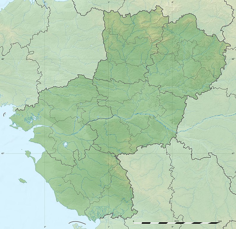
English: Blank physical map of the region of Pays de la Loire, France, as in February 2011, for geo-location purpose, with distinct boundaries for regions, departments and arrondissements.
Français : Carte physique vierge de la région des Pays de la Loire, France, telle qu'en février 2011, destinée à la géolocalisation, avec limite distincte des régions, départements et arrondissements. Scales:
Equirectangular projection, WGS84 datum
Geographic limits of the map:
|
||
| Datum | |||
| Fons |
Opus proprium
|
||
| Auctor | Eric Gaba (Sting - fr:Sting) | ||
| Permissio (Reusing this file) |
|
||
| Other versions |
|

| Camera location | | View this and other nearby images on: OpenStreetMap |
|---|
Potestas usoris
Eric Gaba, Wikimedia Commons user Sting, the copyright holder of this work, hereby publishes it under the following license:
This file is licensed under the Creative Commons Attribution-Share Alike 3.0 Unported license.
Attributio: Eric Gaba, Wikimedia Commons user Sting
- Tibi licet:
- communicare – copiare, distribuere et committere hoc opus
- to remix – to adapt the work
- His condicionibus:
- attributio – You must give appropriate credit, provide a link to the license, and indicate if changes were made. You may do so in any reasonable manner, but not in any way that suggests the licensor endorses you or your use.
- aequa parte – If you remix, transform, or build upon the material, you must distribute your contributions under the same or compatible license as the original.
Historia fasciculi
Presso die vel tempore fasciculum videbis, sicut tunc temporis apparuit.
| Dies/Tempus | Minutio | Dimensiones | Usor | Sententia | |
|---|---|---|---|---|---|
| recentissima | 18:16, 2 Martii 2011 | | 1 546 × 1 497 (395 chiliocteti) | Sting | Missing shaded relief on sea area |
| 13:47, 2 Martii 2011 |  | 1 546 × 1 497 (438 chiliocteti) | Sting | == {{int:filedesc}} == {{Information |Description={{en|Blank physical map of the region of Pays de la Loire, France, as in February 2011, for geo-location purpose, with distinct boundaries for regions, departments and arrondisseme |
Nexus ad fasciculum
Ad hunc fasciculum nectit:
Usus fasciculi per inceptus Vicimediorum
Quae incepta Vici fasciculo utuntur:
- Usus in als.wikipedia.org
- Usus in ar.wikipedia.org
- Usus in bg.wikipedia.org
- Usus in bn.wikipedia.org
- Usus in ceb.wikipedia.org
- Usus in cy.wikipedia.org
- Usus in de.wikipedia.org
- Usus in el.wikipedia.org
- Usus in en.wikipedia.org
- Maine (river)
- Ernée (river)
- Thouet
- Lac d'Apremont
- Èvre
- Vègre
- Layon
- Oudon (river)
- Vaige
- Verzée
- Yon (river)
- Smagne
- Chère
- Petite Maine
- Boulogne (river)
- User:Michael!/Project:Location map templates/France
- Grand-Auverné Formation
- Vie (river)
- Module:Location map/data/France Pays de la Loire
- Module:Location map/data/France Pays de la Loire/doc
- User:DutchTreat/Projects/Places
- Bay of Bourgneuf
- Acheneau
- 1799 Vendée earthquake
- Canal de Haute Perche
- Authion
- Blanche (Loire-Atlantique)
View more global usage of this file.