
Fasciculus:PN -A.png
Nulla maior resolutio exstat.
PN_-A.png (500 × 500 elementa imaginalia, magnitudo fasciculi: 9 chiliocteti, typus MIME: image/png)
Summarium
| Descriptio |
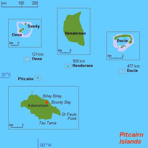
English: Map of Pitcairn Islands (rough), Pacific Ocean, own work composed from various mapreferences |
| Datum | |
| Fons | Opus proprium |
| Auctor | Hobe / Holger Behr |

|
This map image could be re-created using vector graphics as an SVG file. This has several advantages; see Commons:Media for cleanup for more information. If an SVG form of this image is available, please upload it and afterwards replace this template with
{{vector version available|new image name}}.
It is recommended to name the SVG file “PN -A.svg”—then the template Vector version available (or Vva) does not need the new image name parameter. |
Potestas usoris
I, the copyright holder of this work, hereby publish it under the following licenses:
This file is licensed under the Creative Commons Attribution-Share Alike 3.0 Unported license.
- Tibi licet:
- communicare – copiare, distribuere et committere hoc opus
- to remix – to adapt the work
- His condicionibus:
- attributio – You must give appropriate credit, provide a link to the license, and indicate if changes were made. You may do so in any reasonable manner, but not in any way that suggests the licensor endorses you or your use.
- aequa parte – If you remix, transform, or build upon the material, you must distribute your contributions under the same or compatible license as the original.

|
Licet hoc documentum exscribere vel distribuere vel demutare sub GNU Liberarum Litterarum Licentiae conditionibus in editione 1.2 aut in ulla editione recentiori a Fundatione Liberarum Programmationis Partium publicata; praeterquam Sectiones Immutabiles et Verba Involucra Adversa et Aversa. Licentiae exemplar praesto est in sectione intitulata GNU Free Documentation License. |
Tibi typum permissionis ligere licet.
Historia fasciculi
Presso die vel tempore fasciculum videbis, sicut tunc temporis apparuit.
| Dies/Tempus | Minutio | Dimensiones | Usor | Sententia | |
|---|---|---|---|---|---|
| recentissima | 20:22, 13 Maii 2012 | | 500 × 500 (9 chiliocteti) | Túrelio | Reverted to version as of 15:10, 11 November 2010, as it is against our policy to overwrite existing images from other users. |
| 14:45, 6 Maii 2012 |  | 1 378 × 845 (54 chiliocteti) | An678ko | everted to version as of 13:00, 6 May 2012; Pleasе, leave this map! stop modify and update them! Wikipedia is not fun! I added a beautiful card with a modern design! You also try to keep a map which resolution is 500 × 500px. Leave my map 936 × 5... | |
| 10:28, 6 Maii 2012 |  | 500 × 500 (9 chiliocteti) | NordNordWest | Reverted to version as of 15:10, 11 November 2010; duplicate of File:Map of Pitcairn Islands.png | |
| 01:48, 6 Maii 2012 |  | 936 × 503 (32 chiliocteti) | An678ko | redesigned by Aplusc Studio | |
| 15:10, 11 Novembris 2010 |  | 500 × 500 (9 chiliocteti) | Hobe | {{Information |Description={{en|1=Map of Pitcairn Islands (rough), Pacific Ocean, own work composed from various mapreferences}} |Source={{own}} |Author=Hobe / Holger Behr |Date=2010-04-25 |Permission= |other_versions= }} [[Category:Maps of |
Nexus ad fasciculum
Ad hunc fasciculum nectit:
Usus fasciculi per inceptus Vicimediorum
Quae incepta Vici fasciculo utuntur:
- Usus in als.wikipedia.org
- Usus in br.wikipedia.org
- Usus in de.wikipedia.org
- Usus in en.wikipedia.org
- Usus in eo.wikipedia.org
- Usus in fr.wikipedia.org
- Usus in hr.wikipedia.org
- Usus in it.wikipedia.org
- Usus in ja.wikipedia.org
- Usus in li.wikipedia.org
- Usus in my.wikipedia.org
- Usus in nl.wikipedia.org
- Usus in no.wikipedia.org
- Usus in sv.wikipedia.org
- Usus in sv.wikivoyage.org
- Usus in ur.wikipedia.org
- Usus in vi.wikipedia.org