
Fasciculus:Ottoman Empire 1914 h.PNG

Mensura huius perspectionis: 518 × 600 elementa imaginalia. Aliae mensurae: 207 × 240 elementa imaginalia | 415 × 480 elementa imaginalia | 640 × 741 elementa imaginalia.
Sua resolutio (640 × 741 elementa imaginalia, magnitudo fasciculi: 27 chiliocteti, typus MIME: image/png)
Summarium
| Descriptio |
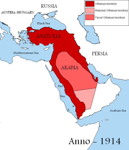
English: Map showing the territories of the Ottoman Empire in 1914, including nominal and vassal territories.
According to the information on the map in http://ottomanmilitary.devhub.com/ |
| Datum | |
| Fons | Opus proprium |
| Auctor | DragonTiger23 |
| Other versions |
[]
|


Many people actually lived in this empire from time to time
Potestas usoris
| I, the copyright holder of this work, release this work into the public domain. This applies worldwide. In some countries this may not be legally possible; if so: I grant anyone the right to use this work for any purpose, without any conditions, unless such conditions are required by law. |

|
This historical map image could be re-created using vector graphics as an SVG file. This has several advantages; see Commons:Media for cleanup for more information. If an SVG form of this image is available, please upload it and afterwards replace this template with
{{vector version available|new image name}}.
It is recommended to name the SVG file “Ottoman Empire 1914 h.svg”—then the template Vector version available (or Vva) does not need the new image name parameter. |
Historia fasciculi
Presso die vel tempore fasciculum videbis, sicut tunc temporis apparuit.
| Dies/Tempus | Minutio | Dimensiones | Usor | Sententia | |
|---|---|---|---|---|---|
| recentissima | 13:04, 29 Augusti 2019 | | 640 × 741 (27 chiliocteti) | Aybeg | Cyprus was under British control. |
| 14:20, 28 Augusti 2019 |  | 640 × 741 (27 chiliocteti) | Aybeg | In 1914, the Ottomans did not rule over Egypt and Sudan. | |
| 13:03, 13 Ianuarii 2011 |  | 640 × 741 (33 chiliocteti) | DragonTiger23 | {{Information |Description={{en|1=Map showing the territories of the Ottoman Empire in 1914, including nominal and vassal territories. According to the information on the map in http://ottomanmilitary.devhub.com/}} |Source={{own}} |Author=[[User:DragonTi |
Nexus ad fasciculum
Nullae paginae hoc fasciculo utuntur.
Usus fasciculi per inceptus Vicimediorum
Quae incepta Vici fasciculo utuntur:
- Usus in ar.wikipedia.org
- Usus in be.wikipedia.org
- Usus in bg.wikipedia.org
- Usus in en.wikipedia.org
- Usus in fr.wikipedia.org
- Usus in he.wikipedia.org
- Usus in hu.wikipedia.org
- Usus in it.wikipedia.org
- Usus in nl.wikipedia.org
- Usus in pt.wikipedia.org