
Fasciculus:Ortelius - Maris Pacifici 1589.jpg

Mensura huius perspectionis: 800 × 554 elementa imaginalia. Aliae mensurae: 320 × 222 elementa imaginalia | 640 × 443 elementa imaginalia | 1 024 × 709 elementa imaginalia | 1 280 × 886 elementa imaginalia | 2 560 × 1 773 elementa imaginalia | 4 001 × 2 771 elementa imaginalia.
Sua resolutio (4 001 × 2 771 elementa imaginalia, magnitudo fasciculi: 3.81 megaocteti, typus MIME: image/jpeg)
|
Summarium
| Descriptio |
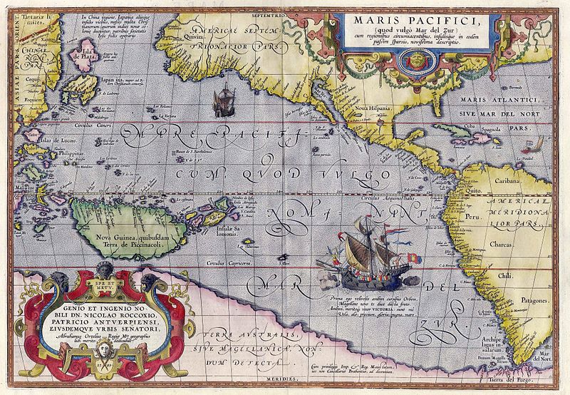
English: Maris Pacifici by Abraham Ortelius. This map was published in 1589 in his Theatrum Orbis Terrarum. It was not only the first printed map of the Pacific, but it also showed the Americas for the first time. Español: Maris Pacifici de Abraham Ortelius. Este mapa fue publicado en 1589 en su Theatrum Orbis Terrarum. No solo fue el primer mapa impreso del Pacífico, sino que también mostró las Américas por primera vez. Bajo la ilustración de la nao Victoria cruzando el Pacífico puede leer lo siguiente en latín: «Prima ego velivovis ambivi cursibus Orbem, Magellane novo te duce ducta freto. Ambivi, meritoque vocor VICTORIA: sunt mî Vela, alæ; precium, gloria: pugna mare» (en español, «Fui la primera en navegar alrededor del mundo por medio de velas, y te llevé a ti, Magallanes, líder, primero a través del estrecho. Navegué alrededor del mundo, por lo tanto, justamente me llamo Victoria, mis velas eran mis alas, mi premio era la gloria, mi lucha era con el mar»). |
|||||||||||||||||||||||
| Datum | ||||||||||||||||||||||||
| Fons | Helmink Antique Maps | |||||||||||||||||||||||
| Auctor |
|
|||||||||||||||||||||||
| Permissio (Reusing this file) |
|
|||||||||||||||||||||||
| Other versions |
|
|||||||||||||||||||||||


Historia fasciculi
Presso die vel tempore fasciculum videbis, sicut tunc temporis apparuit.
| Dies/Tempus | Minutio | Dimensiones | Usor | Sententia | |
|---|---|---|---|---|---|
| recentissima | 15:50, 5 Maii 2007 | | 4 001 × 2 771 (3.81 megaocteti) | Jan Arkesteijn | {{Information |Description=Maris Pacifici by Abraham Ortelius |Source=[http://www.helmink.com/Antique_Map_Ortelius_Pacific/ Helmink Antique Maps] |Date=1589 |Author=Abraham Ortelius }} This map was published in 1589 in his 'Theatrum Orbis Terrarum'. It w |
Nexus ad fasciculum
Ad hunc fasciculum nectunt:
Usus fasciculi per inceptus Vicimediorum
Quae incepta Vici fasciculo utuntur:
- Usus in als.wikipedia.org
- Usus in ar.wikipedia.org
- Usus in azb.wikipedia.org
- Usus in az.wikipedia.org
- Usus in bcl.wikipedia.org
- Usus in be.wikipedia.org
- Usus in bn.wikipedia.org
- Usus in bo.wikipedia.org
- Usus in ca.wikipedia.org
- Usus in ckb.wikipedia.org
- Usus in da.wikipedia.org
- Usus in de.wikipedia.org
- Usus in en.wikipedia.org
- Pacific Ocean
- Abraham Ortelius
- Theatrum Orbis Terrarum
- Portal:Maps/Selected picture
- Wikipedia:Featured pictures thumbs/11
- Wikipedia:Featured picture candidates/March-2008
- Wikipedia:Featured picture candidates/File:Ortelius - Maris Pacifici 1589.jpg
- Wikipedia:Wikipedia Signpost/2008-03-31/Features and admins
- Wikipedia:Featured pictures/Diagrams, drawings, and maps/Maps
- Maris Pacifici
- User talk:Paulcmnt/Archive 1
- Wikipedia:Wikipedia Signpost/2008-03-31/SPV
- Wikipedia:Picture of the day/October 2008
- Template:POTD/2008-10-23
- Portal:Maps/Selected picture/50
- Wikipedia:Graphics Lab/Photography workshop/Archive/Jul 2010
- Portal:Oceans
- Wikipedia:Contents/gallery2
- Wikipedia:Wikipedia Signpost/Single/2008-03-31
- Usus in es.wikipedia.org
- Usus in fr.wikipedia.org
- Usus in fr.wikiversity.org
- Usus in fy.wikipedia.org
- Usus in gcr.wikipedia.org
- Usus in gl.wikipedia.org
- Usus in he.wikipedia.org
- Usus in hi.wikipedia.org
- Usus in hu.wikipedia.org
View more global usage of this file.