
Fasciculus:NewIrelandOMC.png
Nulla maior resolutio exstat.
NewIrelandOMC.png (491 × 365 elementa imaginalia, magnitudo fasciculi: 13 chiliocteti, typus MIME: image/png)
Summarium
| Descriptio |
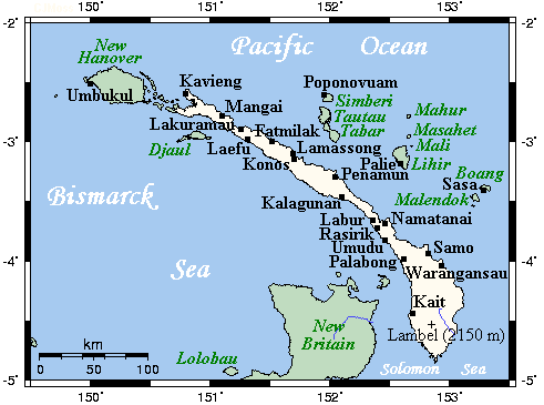
English: A map showing main towns and volcanoes of New Ireland, Bismarck Archipelago, Papau New Guinea |
| Datum | not specified |
| Fons | This map's source is here, with the uploader's modifications, and the GMT homepage says that the tools are released under the GNU General Public License |
| Auctor | Kelisi at en.wikipedia |
Potestas usoris
Kelisi from en.wikipedia.org, the copyright holder of this work, hereby publishes it under the following license:
| This file is licensed under the Creative Commons Attribution-Share Alike 3.0 Unported license. Subject to disclaimers. | ||
| Attributio: Kelisi from en.wikipedia.org | ||
| ||
| This licensing tag was added to this file as part of the GFDL licensing update. |

|
Licet hoc documentum exscribere vel distribuere vel demutare sub GNU Liberarum Litterarum Licentiae conditionibus in editione 1.2 aut in ulla editione recentiori a Fundatione Liberarum Programmationis Partium publicata; praeterquam Sectiones Immutabiles et Verba Involucra Adversa et Aversa. Licentiae exemplar praesto est in sectione intitulata GNU Free Documentation License. Subject to disclaimers. |
Original upload log
All following user names refer to en.wikipedia.
- 2007-07-21 23:37 Kelisi 491×349×8 (13 KB) (== Summary == A map showing New Ireland's main towns and nearby islands. This map's source is [http://www.aquarius.ifm-geomar.de/ here], with the uploader's modifications, and the [http://gmt.soest.hawaii.edu/ GMT homepage] says that the tools are release)
Historia fasciculi
Presso die vel tempore fasciculum videbis, sicut tunc temporis apparuit.
| Dies/Tempus | Minutio | Dimensiones | Usor | Sententia | |
|---|---|---|---|---|---|
| recentissima | 10:21, 14 Iulii 2008 | | 491 × 365 (13 chiliocteti) | Telim tor | == Information == {{Information |Description={{en|A map showing main towns and volcanoes of New Ireland, Bismarck Archipelago, Papau New Guinea}} |Source=This map's source is [http://www.aquarius.ifm-geomar.de/ here], with the uploader's modifications, an |
Nexus ad fasciculum
Ad hunc fasciculum nectit:
Usus fasciculi per inceptus Vicimediorum
Quae incepta Vici fasciculo utuntur:
- Usus in af.wikipedia.org
- Usus in als.wikipedia.org
- Usus in ar.wikipedia.org
- Usus in arz.wikipedia.org
- Usus in az.wikipedia.org
- Usus in bg.wikipedia.org
- Usus in br.wikipedia.org
- Usus in ca.wikipedia.org
- Usus in ceb.wikipedia.org
- Usus in cs.wikipedia.org
- Usus in cy.wikipedia.org
- Usus in de.wikipedia.org
- Usus in de.wikivoyage.org
- Usus in el.wikipedia.org
- Usus in en.wikipedia.org
- Usus in eo.wikipedia.org
- Usus in es.wikipedia.org
- Usus in eu.wikipedia.org
- Usus in fa.wikipedia.org
- Usus in ga.wikipedia.org
- Usus in gl.wikipedia.org
- Usus in he.wikipedia.org
- Usus in hr.wikipedia.org
- Usus in hu.wikipedia.org
- Usus in id.wikipedia.org
- Usus in is.wikipedia.org
- Usus in ja.wikipedia.org
- Usus in ka.wikipedia.org
- Usus in ko.wikipedia.org
- Usus in ml.wikipedia.org
- Usus in mrj.wikipedia.org
- Usus in nl.wikipedia.org
- Usus in pl.wikipedia.org
- Usus in pnb.wikipedia.org
- Usus in ro.wikipedia.org
- Usus in ru.wikipedia.org
- Usus in sk.wikipedia.org
- Usus in sv.wikipedia.org
- Usus in ta.wikipedia.org
- Usus in th.wikipedia.org
- Usus in tr.wikipedia.org
- Usus in war.wikipedia.org
- Usus in www.wikidata.org