
Fasciculus:Map of Franz Josef Land-en.svg

Size of this PNG preview of this SVG file: 800 × 535 elementa imaginalia. Aliae mensurae: 320 × 214 elementa imaginalia | 640 × 428 elementa imaginalia | 1 024 × 685 elementa imaginalia | 1 280 × 856 elementa imaginalia | 2 560 × 1 712 elementa imaginalia | 1 289 × 862 elementa imaginalia.
Sua resolutio (fasciculus SVG, nominale 1 289 × 862 elementa imaginalia, magnitudo fasciculi: 719 chiliocteti)
Summarium
| Descriptio |
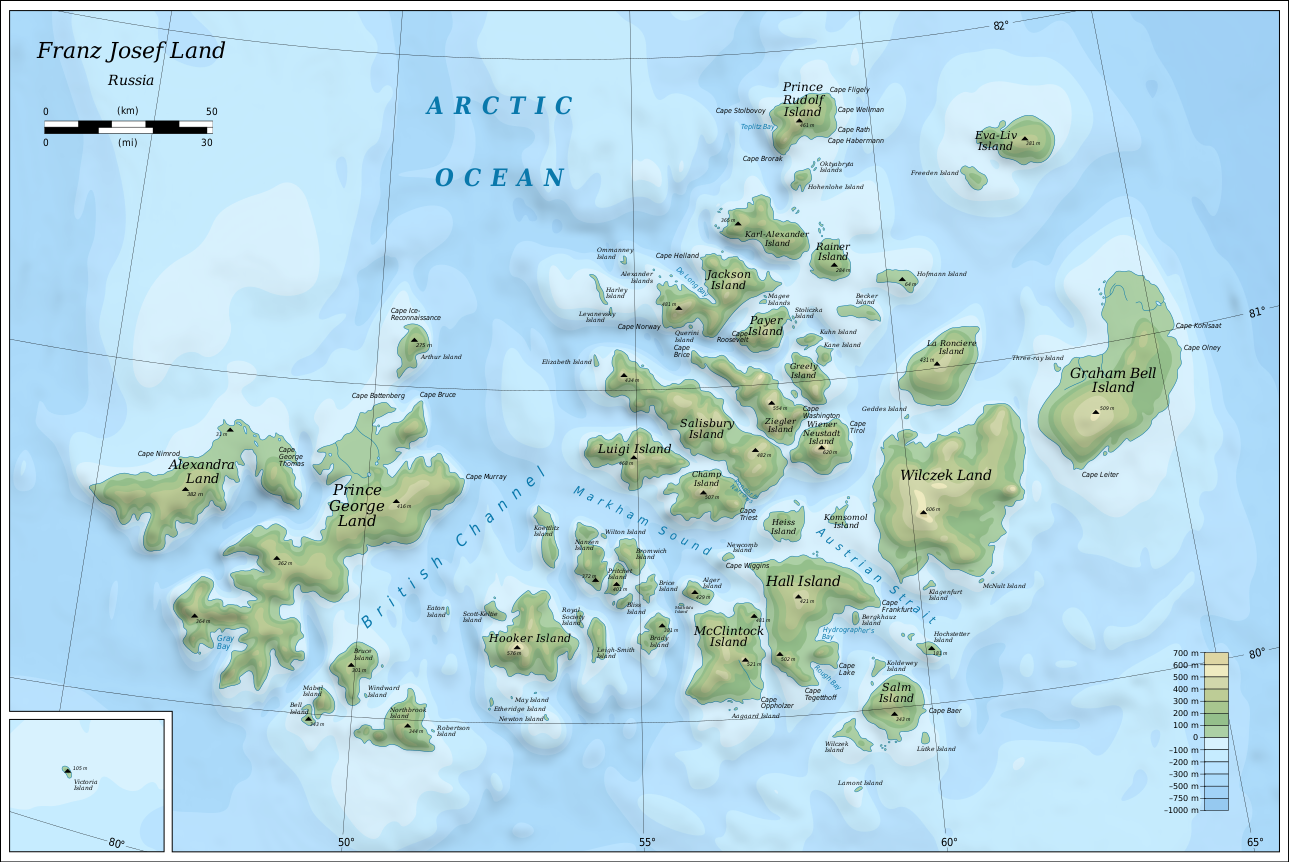
English: Map of Franz Josef Land of Russia. |
| Datum | |
| Fons |
Own work using: Inkscape.
|
| Auctor | Oona Räisänen |
| Other versions |
|
| SVG genesis |


Potestas usoris
I, the copyright holder of this work, hereby publish it under the following licenses:
This file is licensed under the Creative Commons Attribution-Share Alike 3.0 Unported license.
- Tibi licet:
- communicare – copiare, distribuere et committere hoc opus
- to remix – to adapt the work
- His condicionibus:
- attributio – You must give appropriate credit, provide a link to the license, and indicate if changes were made. You may do so in any reasonable manner, but not in any way that suggests the licensor endorses you or your use.
- aequa parte – If you remix, transform, or build upon the material, you must distribute your contributions under the same or compatible license as the original.

|
Licet hoc documentum exscribere vel distribuere vel demutare sub GNU Liberarum Litterarum Licentiae conditionibus in editione 1.2 aut in ulla editione recentiori a Fundatione Liberarum Programmationis Partium publicata; praeterquam Sectiones Immutabiles et Verba Involucra Adversa et Aversa. Licentiae exemplar praesto est in sectione intitulata GNU Free Documentation License. |
Tibi typum permissionis ligere licet.
Historia fasciculi
Presso die vel tempore fasciculum videbis, sicut tunc temporis apparuit.
| Dies/Tempus | Minutio | Dimensiones | Usor | Sententia | |
|---|---|---|---|---|---|
| recentissima | 06:05, 12 Augusti 2019 | | 1 289 × 862 (719 chiliocteti) | Cherkash | fixed some objects: names spelling, location |
| 14:24, 28 Octobris 2010 |  | 1 289 × 862 (719 chiliocteti) | Mysid | shading + fixes | |
| 19:21, 26 Octobris 2010 |  | 1 289 × 862 (719 chiliocteti) | Mysid | bigger fonts | |
| 19:13, 26 Octobris 2010 |  | 1 289 × 862 (718 chiliocteti) | Mysid | {{Information |Description={{en|1=Map of en:Franz Josef Land of Russia.}} |Source={{own}}. Self-made in Inkscape. Topography and shoreline manually derived from a 1964 map by United States Army Map Service, Corps of Engineers ([[:File:NU-38-39-40-41 |
Nexus ad fasciculum
Ad hunc fasciculum nectunt:
Usus fasciculi per inceptus Vicimediorum
Quae incepta Vici fasciculo utuntur:
- Usus in af.wikipedia.org
- Usus in ar.wikipedia.org
- Usus in avk.wikipedia.org
- Wilczek (ewala)
- Teza:FranzJosefTursia
- Salm (ewala)
- Lütke (ewala)
- Hochstetter (ewala)
- Wilczek (ewalama)
- Schönau (ewala)
- Koldewey (ewala)
- Hall (ewala)
- Berghaus (ewala)
- McClintock (ewala)
- Heiss (ewala)
- Komsomol (ewala)
- Newcomb (ewala)
- Alger (ewala)
- Brice (ewala)
- Brady (ewala)
- Bliss (ewala)
- Nansen (ewala)
- Pritchett (ewala)
- Bromwich (ewala)
- Koettlitz (ewala)
- Hooker (ewala)
- Scott-Keltie (ewala)
- Royal Society (ewala)
- Leigh-Smith (ewala)
- Luigi (ewala)
- Salisbury (ewala)
- Champ (ewala)
- Ziegler (ewala)
- Wiener Neustadt (ewala)
- Franz-Josef (tursia)
- Greely (ewala)
- Kane (ewala)
- Kuhn (ewala)
- Payer (ewala)
- Jackson (ewala)
- Karl-Alexander (ewala)
- Rainer (ewala)
- Hohenlohe (ewala)
- Prince Rudolf (ewala)
- La Roncière (ewala)
- Becker (ewala)
- Hofmann (ewala)
- Freeden (ewala)
- Eva-Liv (ewala)
- Graham Bell (ewala)
- Bruce (ewala)
View more global usage of this file.