
Fasciculus:Map France 1030-de.svg

Size of this PNG preview of this SVG file: 527 × 600 elementa imaginalia. Aliae mensurae: 211 × 240 elementa imaginalia | 422 × 480 elementa imaginalia | 675 × 768 elementa imaginalia | 900 × 1 024 elementa imaginalia | 1 800 × 2 048 elementa imaginalia | 988 × 1 124 elementa imaginalia.
Sua resolutio (fasciculus SVG, nominale 988 × 1 124 elementa imaginalia, magnitudo fasciculi: 1.49 megaocteti)
Summarium
| Descriptio |
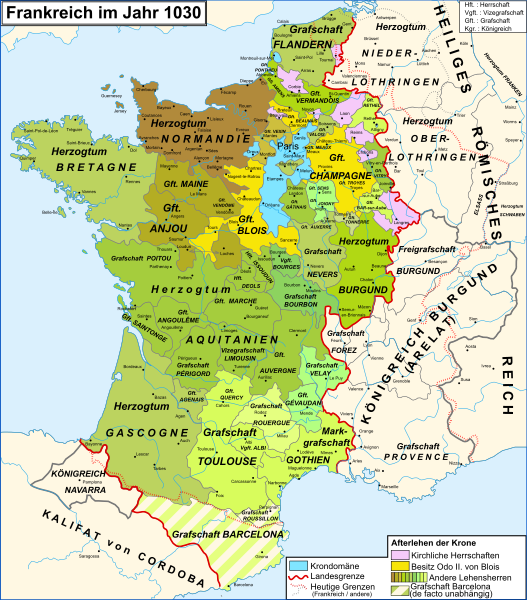
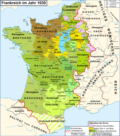
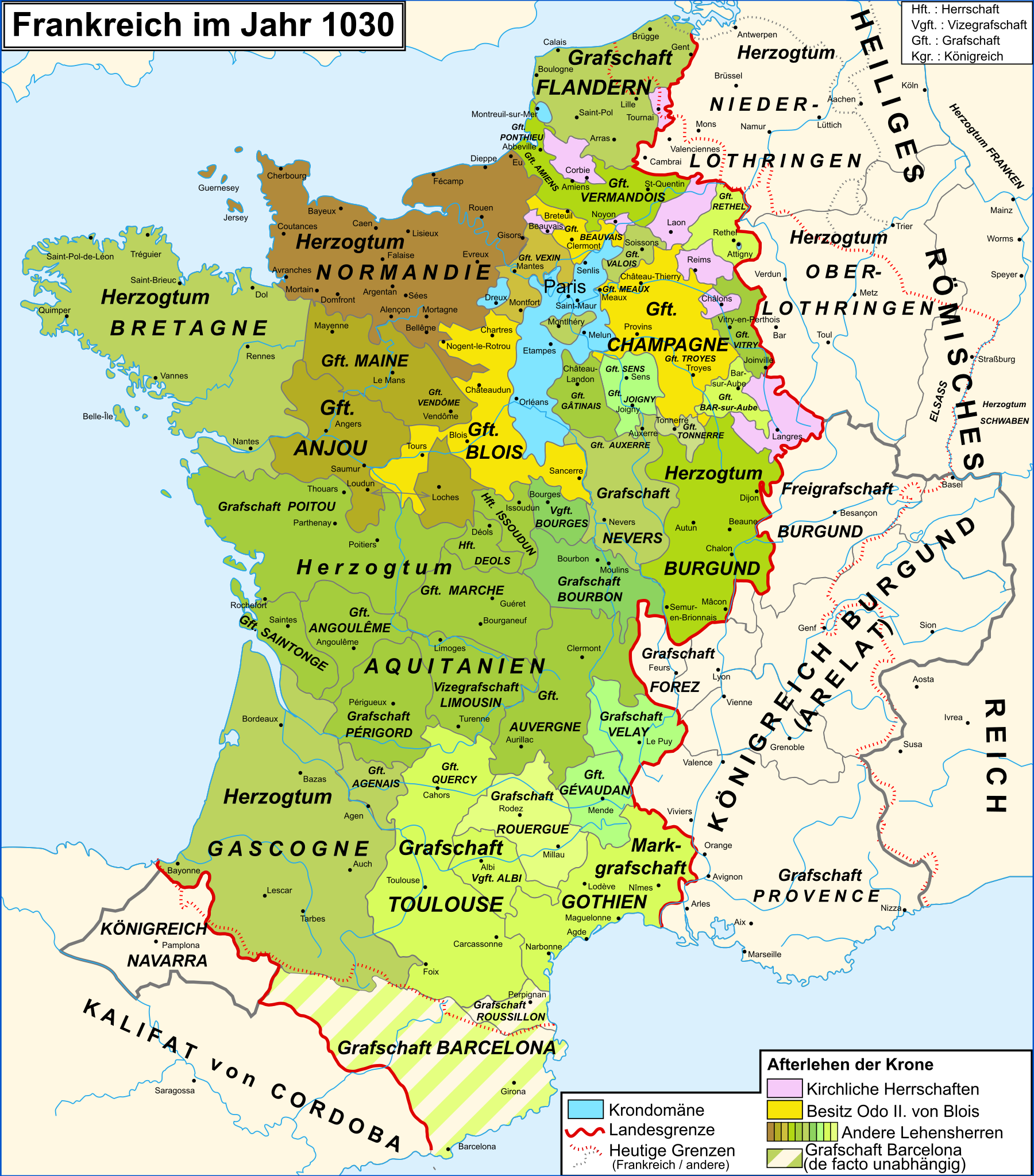
Deutsch: Karte Frankreichs im Jahr 1030
Français : Carte de la France en 1030
English: Map of the France in 1030 |
| Datum | (UTC) |
| Fons | |
| Auctor |
|
| Other versions |
[]
|
| SVG genesis | This vector image was created with Adobe Illustrator. |


Legende
| This is a retouched picture, which means that it has been digitally altered from its original version. Modifications: traduction allemand/deutsche Übersetzung/German translation. The original can be viewed here: Map France 1030-fr.svg:
|
Potestas usoris
I, the copyright holder of this work, hereby publish it under the following licenses:
This file is licensed under the Creative Commons Attribution-Share Alike 3.0 Unported, 2.5 Generic, 2.0 Generic and 1.0 Generic license.
- Tibi licet:
- communicare – copiare, distribuere et committere hoc opus
- to remix – to adapt the work
- His condicionibus:
- attributio – You must give appropriate credit, provide a link to the license, and indicate if changes were made. You may do so in any reasonable manner, but not in any way that suggests the licensor endorses you or your use.
- aequa parte – If you remix, transform, or build upon the material, you must distribute your contributions under the same or compatible license as the original.

|
Licet hoc documentum exscribere vel distribuere vel demutare sub GNU Liberarum Litterarum Licentiae conditionibus in editione 1.2 aut in ulla editione recentiori a Fundatione Liberarum Programmationis Partium publicata; praeterquam Sectiones Immutabiles et Verba Involucra Adversa et Aversa. Licentiae exemplar praesto est in sectione intitulata GNU Free Documentation License. |
Tibi typum permissionis ligere licet.
Original upload log
This image is a derivative work of the following images:
- File:Map_France_1030-fr.svg licensed with Cc-by-sa-3.0,2.5,2.0,1.0, GFDL
- 2010-10-19T16:47:44Z Sxilderik 988x1124 (832361 Bytes) ajouté quelques accents ( PERIGORD, ... )
- 2009-01-23T15:29:02Z Zigeuner 988x1124 (832365 Bytes) Légendes déplacées
- 2009-01-23T15:05:05Z Zigeuner 988x1124 (826462 Bytes) Marquisat de Gothie : même couleur que le comté de Toulouse Comté de Barcelone : + hachures Iles atlantiques : + couleurs
- 2008-06-18T20:16:34Z Zigeuner 988x1124 (810778 Bytes) {{Information |Description={{en|1=Map of the France in 1030}} {{fr|1=Carte de la France en 1030}} |Source=travail personnel (own work) [http://www.lib.utexas.edu/maps/historical/shepherd_1911/shepherd-c-061.jpg] |Author=[[Use
Uploaded with derivativeFX
Historia fasciculi
Presso die vel tempore fasciculum videbis, sicut tunc temporis apparuit.
| Dies/Tempus | Minutio | Dimensiones | Usor | Sententia | |
|---|---|---|---|---|---|
| recentissima | 21:06, 23 Augusti 2016 | | 988 × 1 124 (1.49 megaocteti) | Furfur | SVG aufgeräumt, jetzt valides SVG, Dateigröße signifikant kleiner |
| 21:12, 25 Decembris 2011 |  | 988 × 1 124 (1.96 megaocteti) | Furfur | Details | |
| 20:42, 25 Decembris 2011 |  | 988 × 1 124 (1.96 megaocteti) | Furfur | == {{int:filedesc}} == {{Information |Description={{de|1=Karte Frankreichs im Jahr 1030}} {{fr|1=Carte de la France en 1030}} {{en|1=Map of the France in 1030}} |Source=*File:Map_France_1030-fr.svg |Date=2011-12-25 20:39 (UTC) |Author=*[[:File:Map_F |
Nexus ad fasciculum
Ad hunc fasciculum nectit:
Usus fasciculi per inceptus Vicimediorum
Quae incepta Vici fasciculo utuntur:
- Usus in de.wikipedia.org
- Usus in et.wikipedia.org
- Usus in sl.wikipedia.org