
Fasciculus:Kingdom of Sicily 1190.svg

Size of this PNG preview of this SVG file: 550 × 375 elementa imaginalia. Aliae mensurae: 320 × 218 elementa imaginalia | 640 × 436 elementa imaginalia | 1 024 × 698 elementa imaginalia | 1 280 × 873 elementa imaginalia | 2 560 × 1 745 elementa imaginalia.
Sua resolutio (fasciculus SVG, nominale 550 × 375 elementa imaginalia, magnitudo fasciculi: 998 chiliocteti)
Summarium
This W3C-unspecified vector image was created with Inkscape .


.svg)
.svg)
.svg)
.svg)
.svg)


.svg)
.svg)
.svg)


.png)
.png)


.svg)


.svg)

.svg)


.svg)
.svg)
.svg)
.svg)


.svg)
.png)


.svg)


.svg)
.svg)


.svg)


.svg)


.svg)
.svg)
.svg)
.svg)
.svg)
.svg)
.svg)
_cropped.svg)
.svg)
.svg)
.svg)
.svg)
.svg)
.svg)
.svg)
.svg)
.svg)
.svg)
.svg)
.svg)
.svg)
.svg)
.svg)
.svg)
.svg)
.svg)
.svg)
.svg)
.svg)
.svg)
.svg)
.svg)
.svg)
.svg)
.svg)
.svg)
.svg)
.svg)
.svg)
.svg)
.svg)
.svg)
.svg)
.svg)
.svg)
.svg)
.svg)
.svg)
.svg)
.svg)
.svg)
.svg)
.svg)
Potestas usoris
This file is licensed under the Creative Commons Attribution-Share Alike 4.0 International license.
- Tibi licet:
- communicare – copiare, distribuere et committere hoc opus
- to remix – to adapt the work
- His condicionibus:
- attributio – You must give appropriate credit, provide a link to the license, and indicate if changes were made. You may do so in any reasonable manner, but not in any way that suggests the licensor endorses you or your use.
- aequa parte – If you remix, transform, or build upon the material, you must distribute your contributions under the same or compatible license as the original.
Historia fasciculi
Presso die vel tempore fasciculum videbis, sicut tunc temporis apparuit.
| Dies/Tempus | Minutio | Dimensiones | Usor | Sententia | |
|---|---|---|---|---|---|
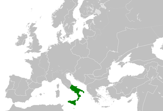
| recentissima | 15:58, 29 Maii 2016 | | 550 × 375 (998 chiliocteti) | Alphathon | == {{int:filedesc}} == {{Inkscape}} {{Information |Description={{en|A map of the Norman en:Kingdom of Sicily within Europe circa 1190 CE. Note that the borders of the Cumans, Kipchaks, Kievan Rus', Kama Bulgarians and Viatka do not extend r... |
Nexus ad fasciculum
Ad hunc fasciculum nectit:
Usus fasciculi per inceptus Vicimediorum
Quae incepta Vici fasciculo utuntur:
- Usus in arz.wikipedia.org
- Usus in ast.wikipedia.org
- Usus in ca.wikipedia.org
- Usus in cs.wikipedia.org
- Usus in en.wikipedia.org
- Usus in eo.wikipedia.org
- Usus in es.wikipedia.org
- Usus in gl.wikipedia.org
- Usus in he.wikipedia.org
- Usus in it.wikipedia.org
- Usus in ja.wikipedia.org
- Usus in ko.wikipedia.org
- Usus in lv.wikipedia.org
- Usus in mk.wikipedia.org
- Usus in pl.wikipedia.org
- Usus in ro.wikipedia.org
- Usus in sc.wikipedia.org
- Usus in simple.wikipedia.org
- Usus in sq.wikipedia.org
- Usus in th.wikipedia.org
- Usus in uk.wikipedia.org
- Usus in vi.wikipedia.org
- Usus in www.wikidata.org