
Fasciculus:Karte Deutsche Bundesländer (nummeriert).svg

Size of this PNG preview of this SVG file: 443 × 599 elementa imaginalia. Aliae mensurae: 177 × 240 elementa imaginalia | 355 × 480 elementa imaginalia | 567 × 768 elementa imaginalia | 757 × 1 024 elementa imaginalia | 1 513 × 2 048 elementa imaginalia | 592 × 801 elementa imaginalia.
Sua resolutio (fasciculus SVG, nominale 592 × 801 elementa imaginalia, magnitudo fasciculi: 110 chiliocteti)
| Descriptio |
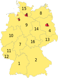
Deutsch: Karte der Bundesrepublik Deutschland mit eingezeichneten Grenzen und alphabetischer Nummerierung der Bundesländer. |
| Datum | |
| Fons | Erstellt aus Material des gemeinsamen Datenangebotes aus dem gemeinsamen Portal der statistischen Ämter des Bundes und der Länder (DeStatis). [1] |
| Auctor | David Liuzzo |
| Permissio (Reusing this file) |
This file is licensed under the Creative Commons Attribution-Share Alike 2.0 Germany license.
 |
| Other versions |
|
| SVG genesis | This map was created with Adobe Illustrator. |
.svg)

.svg)
Historia fasciculi
Presso die vel tempore fasciculum videbis, sicut tunc temporis apparuit.
| Dies/Tempus | Minutio | Dimensiones | Usor | Sententia | |
|---|---|---|---|---|---|
| recentissima | 11:15, 16 Martii 2016 | | 592 × 801 (110 chiliocteti) | Roman Poulvas | New Map of States of Germany (with Area States & City States) |
| 12:14, 16 Octobris 2006 |  | 592 × 801 (110 chiliocteti) | David Liuzzo | Minor fixes; same licensing applies | |
| 17:36, 14 Octobris 2006 |  | 592 × 801 (110 chiliocteti) | David Liuzzo | {{Information| |Description= {{de|Karte der Bundesrepublik Deutschland mit eingezeichneten Grenzen und alphabetischer Nummerierung der Bundesländer.}} |Source= Erstellt aus Material des gemeinsamen Datenangebotes au |
Nexus ad fasciculum
Ad hunc fasciculum nectunt:
Usus fasciculi per inceptus Vicimediorum
Quae incepta Vici fasciculo utuntur:
- Usus in af.wikipedia.org
- Usus in als.wikipedia.org
- Usus in an.wikipedia.org
- Usus in ar.wikipedia.org
- Usus in ast.wikipedia.org
- Usus in ba.wikipedia.org
- Usus in be-tarask.wikipedia.org
- Usus in bg.wikipedia.org
- Usus in br.wikipedia.org
- Usus in bs.wikipedia.org
- Usus in ca.wikipedia.org
- Usus in ce.wikipedia.org
- Usus in cu.wikipedia.org
- Usus in cy.wikipedia.org
- Usus in da.wikipedia.org
- Usus in de.wikipedia.org
- Usus in de.wikibooks.org
- Usus in de.wikinews.org
- Usus in dsb.wikipedia.org
- Usus in en.wikipedia.org
- Usus in es.wikipedia.org
- Usus in ext.wikipedia.org
- Usus in ff.wikipedia.org
- Usus in fi.wikipedia.org
- Usus in frr.wikipedia.org
- Usus in fr.wikipedia.org
- Usus in fy.wikipedia.org
- Usus in gn.wikipedia.org
- Usus in gv.wikipedia.org
- Usus in he.wikipedia.org
View more global usage of this file.
.svg)
.svg)