
Fasciculus:Croatia location map, Karlovac county.svg

Size of this PNG preview of this SVG file: 619 × 599 elementa imaginalia. Aliae mensurae: 248 × 240 elementa imaginalia | 496 × 480 elementa imaginalia | 793 × 768 elementa imaginalia | 1 058 × 1 024 elementa imaginalia | 2 116 × 2 048 elementa imaginalia | 1 097 × 1 062 elementa imaginalia.
Sua resolutio (fasciculus SVG, nominale 1 097 × 1 062 elementa imaginalia, magnitudo fasciculi: 453 chiliocteti)
| Descriptio |
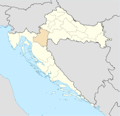
Deutsch: Positionskarte von Kroatien Hervorhebung der Gespanschaft Karlovac. Quadratische Plattkarte, N-S-Streckung 140 %. Geographische Begrenzung der Karte: * N: 46.8° N * S: 42.1° N * W: 13.1° O * O: 19.9° O English: Location map of Croatia Karlovac county highlighted. Equirectangular projection, N/S stretching 140 %. Geographic limits of the map: * N: 46.8° N * S: 42.1° N * W: 13.1° E * E: 19.9° E |
| Datum | (UTC) |
| Fons | |
| Auctor |
|
| This is a retouched picture, which means that it has been digitally altered from its original version. The original can be viewed here: Croatia location map.svg:
|
I, the copyright holder of this work, hereby publish it under the following licenses:
This file is licensed under the Creative Commons Attribution-Share Alike 3.0 Unported license.
- Tibi licet:
- communicare – copiare, distribuere et committere hoc opus
- to remix – to adapt the work
- His condicionibus:
- attributio – You must give appropriate credit, provide a link to the license, and indicate if changes were made. You may do so in any reasonable manner, but not in any way that suggests the licensor endorses you or your use.
- aequa parte – If you remix, transform, or build upon the material, you must distribute your contributions under the same or compatible license as the original.

|
Licet hoc documentum exscribere vel distribuere vel demutare sub GNU Liberarum Litterarum Licentiae conditionibus in editione 1.2 aut in ulla editione recentiori a Fundatione Liberarum Programmationis Partium publicata; praeterquam Sectiones Immutabiles et Verba Involucra Adversa et Aversa. Licentiae exemplar praesto est in sectione intitulata GNU Free Documentation License. |
Tibi typum permissionis ligere licet.
Original upload log
This image is a derivative work of the following images:
- Image:Croatia_location_map.svg licensed with Cc-by-sa-3.0, GFDL
- 2008-08-29T08:00:53Z NordNordWest 1097x1062 (491312 Bytes)
- 2008-07-30T15:54:56Z NordNordWest 548x531 (421799 Bytes) more detailed borderlines
- 2008-07-16T16:55:30Z NordNordWest 548x531 (465194 Bytes) {{Information |Description= {{de|Positionskarte von [[:de:Kroatien|Kroatien]]}} Quadratische Plattkarte, N-S-Streckung 140 %. Geographische Begrenzung der Karte: * N: 46.8° N * S: 42.1° N * W: 13.1° O * O: 19.9° O {{en|Lo
Uploaded with derivativeFX
Historia fasciculi
Presso die vel tempore fasciculum videbis, sicut tunc temporis apparuit.
| Dies/Tempus | Minutio | Dimensiones | Usor | Sententia | |
|---|---|---|---|---|---|
| recentissima | 17:56, 29 Iunii 2009 | | 1 097 × 1 062 (453 chiliocteti) | Minestrone | county color change |
| 22:50, 7 Septembris 2008 |  | 1 097 × 1 062 (489 chiliocteti) | Minestrone | {{Information |Description={{de|Positionskarte von Kroatien}} Hervorhebung der Gespanschaft Karlovac. Quadratische Plattkarte, N-S-Streckung 140 %. Geographische Begrenzung der Karte: * N: 46.8° N * S: 42.1° N * W: 13.1° O * O: 19.9° |
Nexus ad fasciculum
Nullae paginae hoc fasciculo utuntur.
Usus fasciculi per inceptus Vicimediorum
Quae incepta Vici fasciculo utuntur:
- Usus in ar.wikipedia.org
- Usus in ca.wikipedia.org
- Usus in de.wikipedia.org
- Usus in eo.wikipedia.org
- Usus in es.wikipedia.org
- Usus in fi.wikipedia.org
- Usus in frr.wikipedia.org
- Usus in fr.wikipedia.org
- Usus in id.wikipedia.org
- Usus in ka.wikipedia.org
- Usus in lt.wikipedia.org
- Usus in mk.wikipedia.org
- Usus in nn.wikipedia.org
- Usus in pl.wikipedia.org
- Usus in pnb.wikipedia.org
- Usus in ro.wikipedia.org
- Usus in se.wikipedia.org
- Usus in sl.wikipedia.org
- Usus in ur.wikipedia.org
- Usus in www.wikidata.org
- Usus in zh-min-nan.wikipedia.org