
Fasciculus:Coconino County incorporated areas Flagstaff highlighted.svg

Size of this PNG preview of this SVG file: 500 × 600 elementa imaginalia. Aliae mensurae: 200 × 240 elementa imaginalia | 400 × 480 elementa imaginalia | 640 × 768 elementa imaginalia | 853 × 1 024 elementa imaginalia | 1 707 × 2 048 elementa imaginalia | 700 × 840 elementa imaginalia.
Sua resolutio (fasciculus SVG, nominale 700 × 840 elementa imaginalia, magnitudo fasciculi: 59 chiliocteti)
Summarium
| Descriptio |
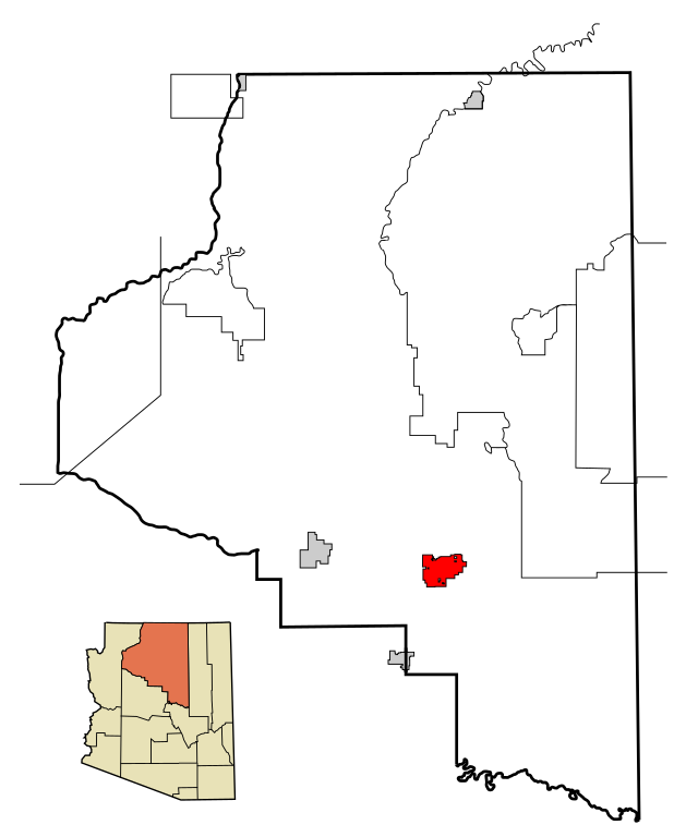
This map shows the incorporated areas and Indian reservations in Coconino County, Arizona.
|
| Datum | |
| Fons | My own work, based on public domain information. Based on similar map concepts by Ixnayonthetimmay |
| Auctor | Arkyan |
| Permissio (Reusing this file) |
Copyleft-type licensing. See below. |
| Other versions | See Category:Maps of Coconino County for other versions of this image. |
Potestas usoris
I, the copyright holder of this work, hereby publish it under the following licenses:

|
Licet hoc documentum exscribere vel distribuere vel demutare sub GNU Liberarum Litterarum Licentiae conditionibus in editione 1.2 aut in ulla editione recentiori a Fundatione Liberarum Programmationis Partium publicata; praeterquam Sectiones Immutabiles et Verba Involucra Adversa et Aversa. Licentiae exemplar praesto est in sectione intitulata GNU Free Documentation License. |
| This file is licensed under the Creative Commons Attribution-Share Alike 3.0 Unported license. | ||
| ||
| This licensing tag was added to this file as part of the GFDL licensing update. |
This file is licensed under the Creative Commons Attribution-Share Alike 2.5 Generic, 2.0 Generic and 1.0 Generic license.
- Tibi licet:
- communicare – copiare, distribuere et committere hoc opus
- to remix – to adapt the work
- His condicionibus:
- attributio – You must give appropriate credit, provide a link to the license, and indicate if changes were made. You may do so in any reasonable manner, but not in any way that suggests the licensor endorses you or your use.
- aequa parte – If you remix, transform, or build upon the material, you must distribute your contributions under the same or compatible license as the original.
Tibi typum permissionis ligere licet.
Historia fasciculi
Presso die vel tempore fasciculum videbis, sicut tunc temporis apparuit.
| Dies/Tempus | Minutio | Dimensiones | Usor | Sententia | |
|---|---|---|---|---|---|
| recentissima | 22:56, 21 Martii 2007 | | 700 × 840 (59 chiliocteti) | Shereth | {{Information |Description=This map shows the incorporated areas and Indian reservations in Coconino County, Arizona, highlighting Flagstaff in red. I created |
Nexus ad fasciculum
Ad hunc fasciculum nectit:
Usus fasciculi per inceptus Vicimediorum
Quae incepta Vici fasciculo utuntur:
- Usus in af.wikipedia.org
- Usus in ar.wikipedia.org
- Usus in arz.wikipedia.org
- Usus in ba.wikipedia.org
- Usus in ca.wikipedia.org
- Usus in ceb.wikipedia.org
- Usus in cy.wikipedia.org
- Usus in de.wikipedia.org
- Usus in el.wikipedia.org
- Usus in eo.wikipedia.org
- Usus in et.wikipedia.org
- Usus in eu.wikipedia.org
- Usus in fr.wikipedia.org
- Usus in fy.wikipedia.org
- Usus in ga.wikipedia.org
- Usus in gl.wikipedia.org
- Usus in ht.wikipedia.org
- Usus in hu.wikipedia.org
- Usus in ia.wikipedia.org
- Usus in id.wikipedia.org
- Usus in lad.wikipedia.org
- Usus in lb.wikipedia.org
- Usus in pt.wikipedia.org
- Usus in ro.wikipedia.org
- Usus in sk.wikipedia.org
- Usus in sr.wikipedia.org
- Usus in th.wikipedia.org
- Usus in tr.wikipedia.org
- Usus in tt.wikipedia.org
- Usus in ur.wikipedia.org
- Usus in vi.wikipedia.org
- Usus in vo.wikipedia.org
- Usus in www.wikidata.org
- Usus in zh-min-nan.wikipedia.org
- Usus in zh.wikipedia.org