
Fasciculus:Champlainmap fr.svg

Size of this PNG preview of this SVG file: 465 × 470 elementa imaginalia. Aliae mensurae: 237 × 240 elementa imaginalia | 475 × 480 elementa imaginalia | 760 × 768 elementa imaginalia | 1 013 × 1 024 elementa imaginalia | 2 026 × 2 048 elementa imaginalia.
Sua resolutio (fasciculus SVG, nominale 465 × 470 elementa imaginalia, magnitudo fasciculi: 99 chiliocteti)
Summarium
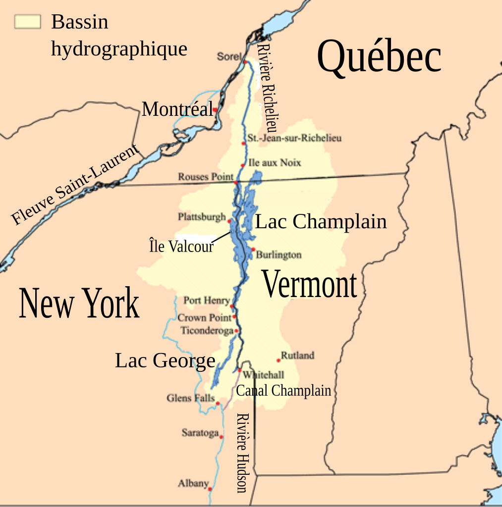
| Descriptio | Cette carte montre le bassin hydrographique du Lac Champlain et de la rivière Richelieu. L'auteur original a utilisé les données du USGS, Bureau du recensement des États-Unis et de Digital Chart of the World data. |
| Datum | (UTC) |
| Fons | Champlainmap.png |
| Auctor |
|
| SVG genesis |
| This is a retouched picture, which means that it has been digitally altered from its original version. The original can be viewed here: Champlainmap.png:
|
Potestas usoris
I, the copyright holder of this work, hereby publish it under the following license:
This file is licensed under the Creative Commons Attribution-Share Alike 2.5 Generic license.
- Tibi licet:
- communicare – copiare, distribuere et committere hoc opus
- to remix – to adapt the work
- His condicionibus:
- attributio – You must give appropriate credit, provide a link to the license, and indicate if changes were made. You may do so in any reasonable manner, but not in any way that suggests the licensor endorses you or your use.
- aequa parte – If you remix, transform, or build upon the material, you must distribute your contributions under the same or compatible license as the original.
Original upload log
This image is a derivative work of the following images:
- File:Champlainmap.png licensed with Cc-by-sa-2.5
- 2011-03-28T23:38:51Z Gilbertus 465x470 (36608 Bytes) retrait du cadre
- 2006-07-26T17:29:43Z Kmusser 500x500 (34969 Bytes)
- 2006-07-26T17:02:12Z Kmusser 500x500 (34791 Bytes) This is a map showing the [[:en:Lake Champlain|Lake Champlain]] - [[:en:Richelieu River|Richelieu River]] watershed. I made using [[:en:United States Geological Survey|USGS]], [[:en:United States Census Bureau|Census Bureau]
Uploaded with derivativeFX
Historia fasciculi
Presso die vel tempore fasciculum videbis, sicut tunc temporis apparuit.
| Dies/Tempus | Minutio | Dimensiones | Usor | Sententia | |
|---|---|---|---|---|---|
| recentissima | 02:00, 26 Decembris 2011 | | 465 × 470 (99 chiliocteti) | Pierre cb | == {{int:filedesc}} == {{Information |Description=Cette carte montre le bassin hydrographique du Lac Champlain et de la rivière Richelieu. L'auteur original a utilisé les données du [[:fr:United States |
Nexus ad fasciculum
Ad hunc fasciculum nectit:
Usus fasciculi per inceptus Vicimediorum
Quae incepta Vici fasciculo utuntur:
- Usus in ceb.wikipedia.org
- Usus in en.wikipedia.org
- Usus in fr.wikipedia.org
- Usus in pt.wikipedia.org
- Usus in www.wikidata.org