
Fasciculus:Carte Skagerrak-Kattegat2.png
Nulla maior resolutio exstat.
Carte_Skagerrak-Kattegat2.png (445 × 508 elementa imaginalia, magnitudo fasciculi: 15 chiliocteti, typus MIME: image/png)
Summarium
| Descriptio |
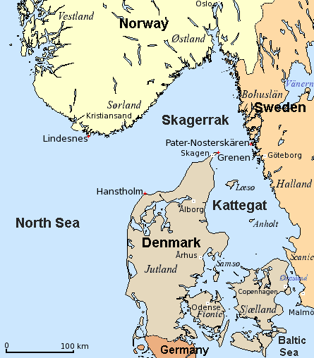
English: Map of Skagerrak and Kattegat — straits/bays of the North Sea, along Denmark, Norway, and Sweden.
Dansk: Kort over Skagerrak og Kattegat (Danmark, Norge, Sverige).
Deutsch: Karte von Skagerrak und Kattegat (Dänemark, Norwegen, Schweden).
Français : Carte du Skagerrak et du Kattegat (Danemark, Norvège, Suède).
|
| Datum | 8 December 2006 (original upload date) |
| Fons |
English: Modification of
Dansk: Bearbejdelse af
Deutsch: Bearbeitung von
File:Carte_Skagerrak-Kattegat.png |
| Auctor | The original uploader was Attilios at Anglica Vicipaedia. |
| Other versions |
|


Potestas usoris
| This file is licensed under the Creative Commons Attribution-Share Alike 3.0 Unported license. Subject to disclaimers. | ||
| ||
| This licensing tag was added to this file as part of the GFDL licensing update. |

|
Licet hoc documentum exscribere vel distribuere vel demutare sub GNU Liberarum Litterarum Licentiae conditionibus in editione 1.2 aut in ulla editione recentiori a Fundatione Liberarum Programmationis Partium publicata; praeterquam Sectiones Immutabiles et Verba Involucra Adversa et Aversa. Licentiae exemplar praesto est in sectione intitulata GNU Free Documentation License. Subject to disclaimers. |
Original upload log
Transferred from en.wikipedia to Commons by Smooth_O using CommonsHelper.
The original description page was here. All following user names refer to en.wikipedia.
- 2006-12-08 19:07 Attilios 445×508×4 (15028 bytes) Modification of Carte_Skagerrak-Kattegat.png {{GFDL}}
Historia fasciculi
Presso die vel tempore fasciculum videbis, sicut tunc temporis apparuit.
| Dies/Tempus | Minutio | Dimensiones | Usor | Sententia | |
|---|---|---|---|---|---|
| recentissima | 18:50, 6 Martii 2018 | | 445 × 508 (15 chiliocteti) | Hohum | Cartographic colours, nations. |
| 13:51, 15 Iunii 2008 |  | 445 × 508 (15 chiliocteti) | File Upload Bot (Magnus Manske) | {{BotMoveToCommons|en.wikipedia}} {{Information |Description={{en|Modification of Carte_Skagerrak-Kattegat.png}} |Source=Transferred from [http://en.wikipedia.org en.wikipedia]; transfered to Commons by User:Smooth_O using [http://tools.wikimedia.de/ |
Nexus ad fasciculum
Ad hunc fasciculum nectunt:
Usus fasciculi per inceptus Vicimediorum
Quae incepta Vici fasciculo utuntur:
- Usus in ar.wikipedia.org
- Usus in ast.wikipedia.org
- Usus in azb.wikipedia.org
- Usus in bn.wikipedia.org
- Usus in bs.wikipedia.org
- Usus in ca.wikipedia.org
- Usus in diq.wikipedia.org
- Usus in el.wikipedia.org
- Usus in en.wikipedia.org
- Usus in es.wikipedia.org
- Usus in eu.wikipedia.org
- Usus in fa.wikipedia.org
- Usus in ga.wikipedia.org
- Usus in gl.wikipedia.org
- Usus in he.wikipedia.org
- Usus in hr.wikipedia.org
- Usus in it.wikipedia.org
- Usus in ja.wikipedia.org
- Usus in ka.wikipedia.org
- Usus in ko.wikipedia.org
- Usus in ku.wikipedia.org
- Usus in lt.wikipedia.org
- Usus in lv.wikipedia.org
- Usus in ps.wikipedia.org
- Usus in ro.wikipedia.org
- Usus in rue.wikipedia.org
- Usus in sco.wikipedia.org
- Usus in sh.wikipedia.org
- Usus in sl.wikipedia.org
View more global usage of this file.