
Fasciculus:Boston, 1775bsmall1.png
Sua resolutio (2 480 × 3 500 elementa imaginalia, magnitudo fasciculi: 15.87 megaocteti, typus MIME: image/png)
|
| This is a retouched picture, which means that it has been digitally altered from its original version. Modifications: dirt and stains removed, levels and color adjusted; slightly cropped and rotated. The original can be viewed here: Boston, 1775small1.png:
|
Summarium
| Descriptio |
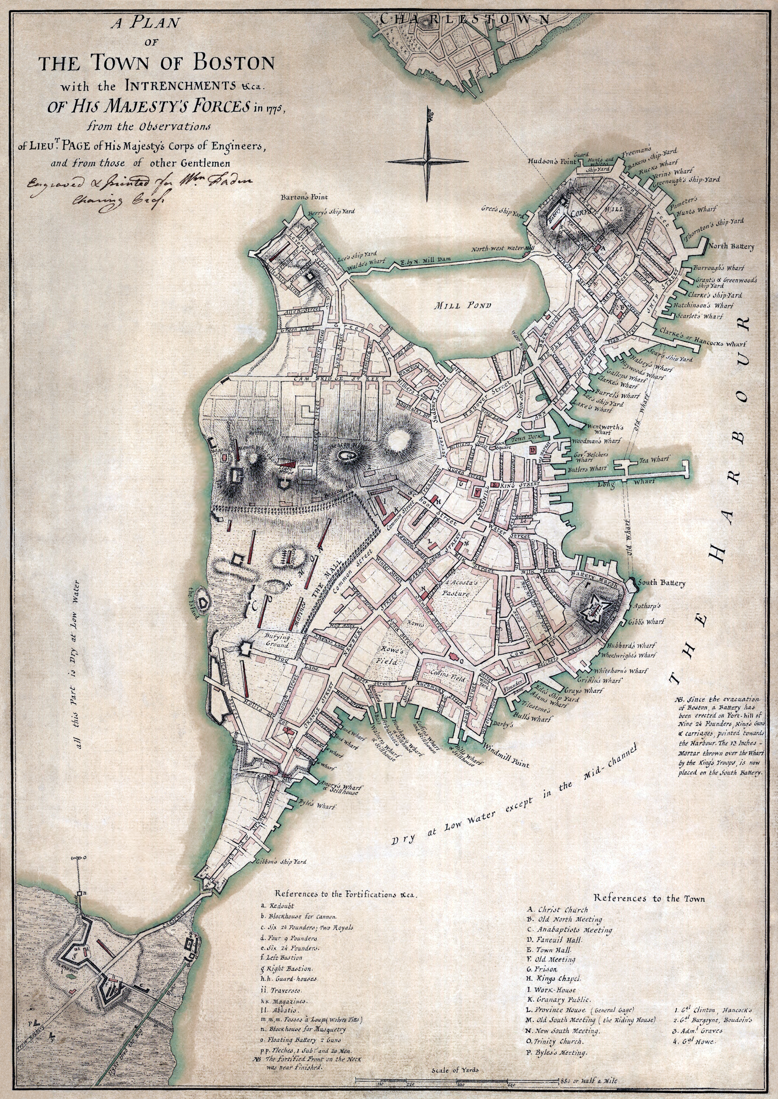
"A plan of the town of Boston with the intrenchments &ca. of His Majesty's forces in 1775, from the observations of Lieut. Page of His Majesty's Corps of Engineers, and from those of other gentlemen." العربية: خريطة تظهر تقييم ميداني بريطاني لبوسطن في عام 1775. |
||||||||||||||||||||
| Datum | |||||||||||||||||||||
| Fons | Library of Congress G3764.B6S3 1777 .P3 Faden 32 | ||||||||||||||||||||
| Auctor |
|
||||||||||||||||||||
| Permissio (Reusing this file) |
|
||||||||||||||||||||
_by_James_Northcote.jpeg)
Historia fasciculi
Presso die vel tempore fasciculum videbis, sicut tunc temporis apparuit.
| Dies/Tempus | Minutio | Dimensiones | Usor | Sententia | |
|---|---|---|---|---|---|
| recentissima | 00:01, 17 Iulii 2008 | | 2 480 × 3 500 (15.87 megaocteti) | Durova | {{Information |Description="A plan of the town of Boston with the intrenchments &ca. of His Majesty's forces in 1775, from the observations of Lieut. Page of His Majesty's Corps of Engineers, and from those of other gentlemen." |Source=Library of Congress |
Nexus ad fasciculum
Ad hunc fasciculum nectit:
Usus fasciculi per inceptus Vicimediorum
Quae incepta Vici fasciculo utuntur:
- Usus in ar.wikipedia.org
- Usus in arz.wikipedia.org
- Usus in cs.wikipedia.org
- Usus in da.wikipedia.org
- Usus in de.wikipedia.org
- Usus in en.wikipedia.org
- Siege of Boston
- Boston Common
- North End, Boston
- Portal:United States/Selected picture
- Boston campaign
- Washington Street (Boston)
- History of Boston
- History of New England
- Portal:North America/Selected picture
- Portal:Maps/Selected picture
- Shawmut Peninsula
- Tremont Street
- Fort Point, Boston
- Massachusetts Provincial Congress
- Wikipedia:Featured pictures thumbs/12
- Wikipedia:WikiProject Military history/Logistics
- Wikipedia:Featured pictures/History/USA History
- Wikipedia:Featured picture candidates/July-2008
- Wikipedia talk:WikiProject Military history/Archive 80
- Wikipedia:Featured picture candidates/File:Boston, 1775bsmall1.png
- Wikipedia:Wikipedia Signpost/2008-07-21/Features and admins
- User talk:Durova/Archive 60
- Wikipedia:Wikipedia Signpost/2008-07-21/SPV
- Portal:North America/Selected picture/61
- Portal:Maps/Selected picture/49
- Wikipedia:Picture of the day/January 2009
- Template:POTD/2009-01-31
- Wikipedia:WikiProject Military history/Showcase
- Wikipedia:WikiProject Military history/Showcase/FP
- User talk:Durova/Archive 65
- User talk:Eric Corbett/Archives/2009/July
- Boston
- User:Durova/Featured credits at the Turkish language Wikipedia
- Hancock's Wharf
- User:Durova/Featured picture gallery/2008
- Wikipedia:WikiProject United States/Recognized content
- Hanover Street (Boston)
- Thomas Hyde Page
- Wikipedia talk:WikiProject Military history/Logistics/Archive 1
View more global usage of this file.