
Fasciculus:Arques drainage basin-fr.svg

Size of this PNG preview of this SVG file: 685 × 599 elementa imaginalia. Aliae mensurae: 274 × 240 elementa imaginalia | 549 × 480 elementa imaginalia | 878 × 768 elementa imaginalia | 1 171 × 1 024 elementa imaginalia | 2 342 × 2 048 elementa imaginalia | 2 258 × 1 975 elementa imaginalia.
Sua resolutio (fasciculus SVG, nominale 2 258 × 1 975 elementa imaginalia, magnitudo fasciculi: 2 megaocteti)
Summarium
| Descriptio |
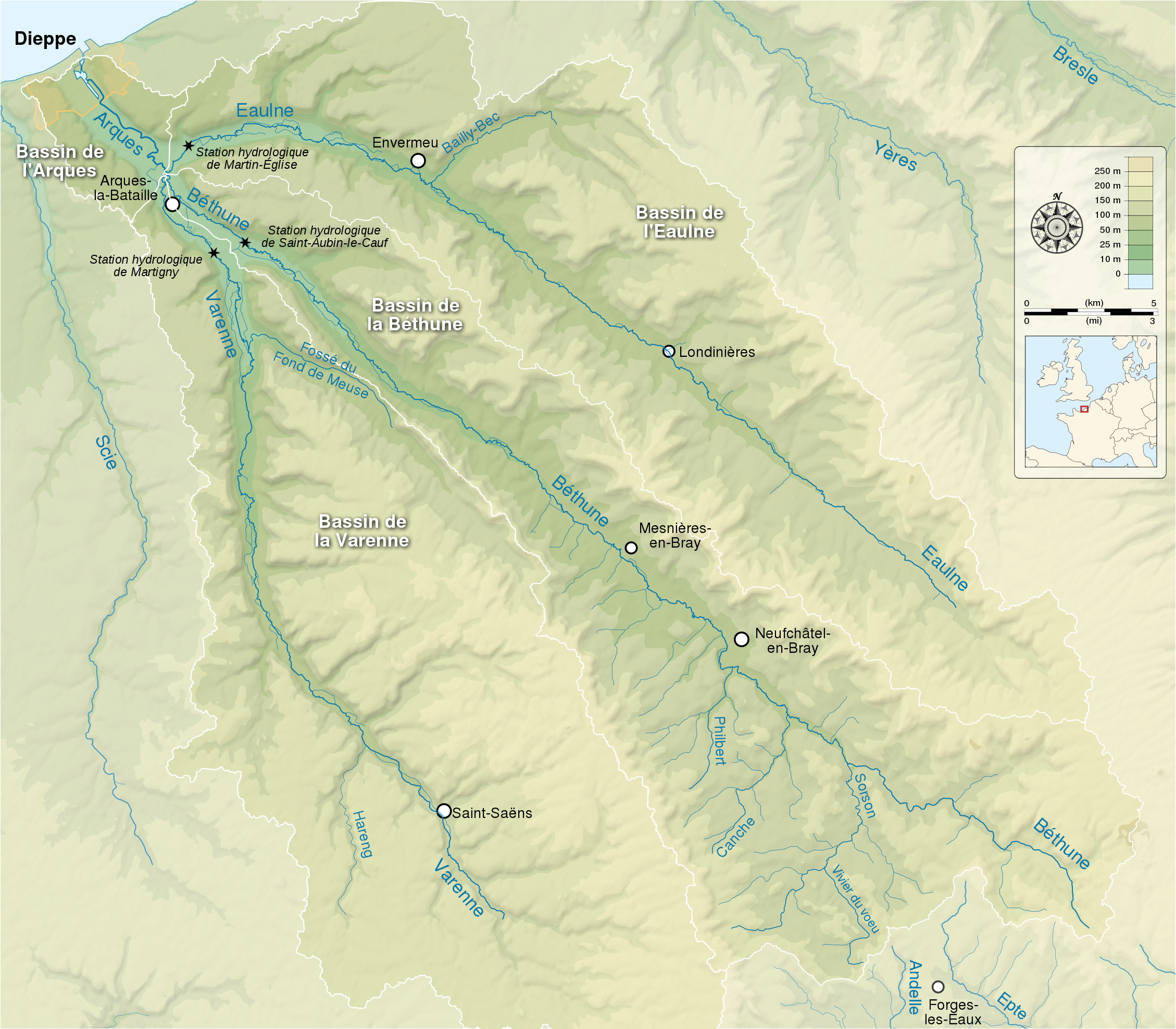
English: Map showing the drainage basin of the Arques river and its three tributaries : the Eaulne, the Béthune and the Varenne. Seine-Maritime, Normandy, France. Français : Carte montrant le bassin versant de l'Arques et de ses trois rivières tributaires : l'Eaulne, la Béthune et la Varenne. Seine-Maritime, Normandie, France. |
| Datum | (UTC) |
| Fons |
English:
Français :
|
| Auctor | |
| Attributio (required by the license) | © Sémhur / Wikimedia Commons / |
| SVG genesis |
| Camera location | | View this and other nearby images on: OpenStreetMap |
|---|
Potestas usoris
I, the copyright holder of this work, hereby publish it under the following licenses:
| Copyleft: This work of art is free; you can redistribute it and/or modify it according to terms of the Free Art License. You will find a specimen of this license on the Copyleft Attitude site as well as on other sites. |
This file is licensed under the Creative Commons Attribution-Share Alike 4.0 International, 3.0 Unported, 2.5 Generic, 2.0 Generic and 1.0 Generic license.
- Tibi licet:
- communicare – copiare, distribuere et committere hoc opus
- to remix – to adapt the work
- His condicionibus:
- attributio – You must give appropriate credit, provide a link to the license, and indicate if changes were made. You may do so in any reasonable manner, but not in any way that suggests the licensor endorses you or your use.
- aequa parte – If you remix, transform, or build upon the material, you must distribute your contributions under the same or compatible license as the original.
Tibi typum permissionis ligere licet.
Historia fasciculi
Presso die vel tempore fasciculum videbis, sicut tunc temporis apparuit.
| Dies/Tempus | Minutio | Dimensiones | Usor | Sententia | |
|---|---|---|---|---|---|
| recentissima | 15:18, 22 Maii 2014 | | 2 258 × 1 975 (2 megaocteti) | Sémhur | Valid SVG |
| 20:15, 9 Septembris 2012 |  | 2 258 × 1 975 (2.07 megaocteti) | Sémhur | == {{int:filedesc}} == {{Information |Description={{Multilingual description |en= Map showing the drainage basin of the Arques river and its three tributaries : the Eaulne, the Béthune and the Varenne. Seine-Maritime, Normandy, ... |
Nexus ad fasciculum
Ad hunc fasciculum nectunt:
Usus fasciculi per inceptus Vicimediorum
Quae incepta Vici fasciculo utuntur:
- Usus in br.wikipedia.org
- Usus in en.wikipedia.org
- Usus in fr.wikipedia.org
- Usus in pt.wikipedia.org
- Usus in ro.wikipedia.org
- Usus in sr.wikipedia.org
- Usus in zh.wikipedia.org