
Fasciculus:Ancient Regions Central Greece.png

Mensura huius perspectionis: 600 × 600 elementa imaginalia. Aliae mensurae: 240 × 240 elementa imaginalia | 480 × 480 elementa imaginalia.
Sua resolutio (800 × 800 elementa imaginalia, magnitudo fasciculi: 393 chiliocteti, typus MIME: image/png)
| Descriptio |
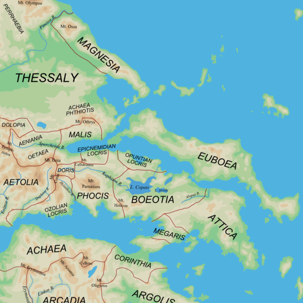
English: Map of the central regions of Ancient Greece |
| Datum | (UTC) |
| Fons |
|
| Auctor | User:MinisterForBadTimes |
| Other versions |
Derivative works of this file: |
| This is a retouched picture, which means that it has been digitally altered from its original version. The original can be viewed here: Ancient Greek southern regions.png:
|
I, the copyright holder of this work, hereby publish it under the following licenses:
This file is licensed under the Creative Commons Attribution-Share Alike 2.5 Generic license.
- Tibi licet:
- communicare – copiare, distribuere et committere hoc opus
- to remix – to adapt the work
- His condicionibus:
- attributio – You must give appropriate credit, provide a link to the license, and indicate if changes were made. You may do so in any reasonable manner, but not in any way that suggests the licensor endorses you or your use.
- aequa parte – If you remix, transform, or build upon the material, you must distribute your contributions under the same or compatible license as the original.
| This file is licensed under the Creative Commons Attribution-Share Alike 3.0 Unported license. | ||
| ||
| This licensing tag was added to this file as part of the GFDL licensing update. |

|
Licet hoc documentum exscribere vel distribuere vel demutare sub GNU Liberarum Litterarum Licentiae conditionibus in editione 1.2 aut in ulla editione recentiori a Fundatione Liberarum Programmationis Partium publicata; praeterquam Sectiones Immutabiles et Verba Involucra Adversa et Aversa. Licentiae exemplar praesto est in sectione intitulata GNU Free Documentation License. |
Tibi typum permissionis ligere licet.
Original upload log
This image is a derivative work of the following images:
- File:Ancient_Greek_southern_regions.png licensed with Cc-by-sa-2.5, Cc-by-sa-3.0-migrated, GFDL
- 2010-01-12T08:44:56Z MinisterForBadTimes 800x800 (385822 Bytes) {{Information |Description={{en|Map of the regions of Ancient Greece}} |Source=*[[:File:Map_greek_sanctuaries-en.svg|]]. Geographical information based on public domain map of Greece, from the Perry-Castañeda Library Map Col
Uploaded with derivativeFX
Historia fasciculi
Presso die vel tempore fasciculum videbis, sicut tunc temporis apparuit.
| Dies/Tempus | Minutio | Dimensiones | Usor | Sententia | |
|---|---|---|---|---|---|
| recentissima | 20:41, 3 Martii 2010 | | 800 × 800 (393 chiliocteti) | MinisterForBadTimes | Two spellings corrected |
| 21:44, 1 Martii 2010 |  | 800 × 800 (393 chiliocteti) | MinisterForBadTimes | {{Information |Description={{en|Map of the central regions of Ancient Greece}} |Source=*blank(ish) map from Ancient_Greek_southern_regions.png, ultimately derived from [[:File:Map_greek_sanctuaries-en.svg|Map_g |
Nexus ad fasciculum
Ad hunc fasciculum nectit:
Usus fasciculi per inceptus Vicimediorum
Quae incepta Vici fasciculo utuntur:
- Usus in azb.wikipedia.org
- Usus in bg.wikipedia.org
- Usus in cs.wikipedia.org
- Usus in de.wikipedia.org
- Usus in el.wikipedia.org
- Usus in en.wikipedia.org
- Usus in et.wikipedia.org
- Usus in fi.wikipedia.org
- Usus in fr.wikipedia.org
- Usus in hu.wikipedia.org
- Usus in id.wikipedia.org
- Usus in it.wikipedia.org
- Usus in ja.wikipedia.org
- Usus in ja.wikibooks.org
- Usus in nn.wikipedia.org
- Usus in pl.wiktionary.org
- Usus in pnb.wikipedia.org
- Usus in ru.wikipedia.org
- Usus in sl.wikipedia.org
- Usus in sq.wikipedia.org
- Usus in tr.wikipedia.org
- Usus in uk.wikipedia.org
View more global usage of this file.