
Fasciculus:AcreNE1799.jpg

Mensura huius perspectionis: 800 × 542 elementa imaginalia. Aliae mensurae: 320 × 217 elementa imaginalia | 640 × 433 elementa imaginalia | 1 065 × 721 elementa imaginalia.
Sua resolutio (1 065 × 721 elementa imaginalia, magnitudo fasciculi: 291 chiliocteti, typus MIME: image/jpeg)
Summarium
| Descriptio |
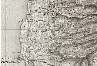
English: Portion of map of Pierre Jacotin of northern Palestine, prepared during French military expedition of 1799 and published in 1826. Full name: Carte topographique de l'Egypte et de plusieurs parties des pays limitrophes ... . David Rumsey Collection |
| Datum | |
| Fons | David Rumsey Collection |
| Auctor | Jacotin, Pierre, 1765-1827 |
Potestas usoris
|
This is a faithful photographic reproduction of a two-dimensional, public domain work of art. The work of art itself is in the public domain for the following reason:
The official position taken by the Wikimedia Foundation is that "faithful reproductions of two-dimensional public domain works of art are public domain".
This photographic reproduction is therefore also considered to be in the public domain in the United States. In other jurisdictions, re-use of this content may be restricted; see Reuse of PD-Art photographs for details. | ||||
Historia fasciculi
Presso die vel tempore fasciculum videbis, sicut tunc temporis apparuit.
| Dies/Tempus | Minutio | Dimensiones | Usor | Sententia | |
|---|---|---|---|---|---|
| recentissima | 15:05, 25 Aprilis 2010 | | 1 065 × 721 (291 chiliocteti) | Zero0000 | Oops, uploaded the wrong file. Trying again. |
| 15:03, 25 Aprilis 2010 |  | 12 400 × 8 135 (21.02 megaocteti) | Zero0000 | {{Information |Description={{en|1=Portion of map of Pierre Jacotin of northern Palestine, prepared during French military expedition of 1799 and published in 1826. Full name: ''Carte topographique de l'Egypte et de plusieurs parties des pays limitrophes |
Nexus ad fasciculum
Ad hunc fasciculum nectit:
Usus fasciculi per inceptus Vicimediorum
Quae incepta Vici fasciculo utuntur:
- Usus in ar.wikipedia.org
- Usus in ca.wikipedia.org
- Usus in de.wikipedia.org
- Usus in en.wikipedia.org
- Usus in fr.wikipedia.org