
Fasciculus:A new draught of the Island of MADAGASCAR ats St. LORENZO with Augustin Bay and the Island of Mombass at Large NYPL1640654.tiff

Size of this JPG preview of this TIF file: 799 × 600 elementa imaginalia. Aliae mensurae: 320 × 240 elementa imaginalia | 640 × 480 elementa imaginalia | 1 023 × 768 elementa imaginalia | 1 280 × 961 elementa imaginalia | 2 560 × 1 922 elementa imaginalia | 7 230 × 5 428 elementa imaginalia.
Sua resolutio (7 230 × 5 428 elementa imaginalia, magnitudo fasciculi: 112.28 megaocteti, typus MIME: image/tiff)
Summarium
| Description |
A new draught of the Island of MADAGASCAR ats St. LORENZO with Augustin Bay and the Island of Mombass at Large; Atlases, gazetteers, guidebooks and other books / The sea-atlas : containing an hydrographical description of most of the sea-coasts of the known parts of the world. |
|||||||||||||||||||||||
| Catalogue call number | Map Div. 02-295 | |||||||||||||||||||||||
| Item/Page/Plate | 132 | |||||||||||||||||||||||
| Standard reference | Sabin 95631 | |||||||||||||||||||||||
| Source description | 1 v. in 2 : maps ; 53 cm. | |||||||||||||||||||||||
| Location | Stephen A. Schwarzman Building / The Lionel Pincus and Princess Firyal Map Division | |||||||||||||||||||||||
| Digital item published | 6-25-2008; updated 3-25-2011 | |||||||||||||||||||||||
| Digital ID | 1640654 | |||||||||||||||||||||||
| Datum | circa 1702 - circa 1707 | |||||||||||||||||||||||
| Fons |
http://digitalgallery.nypl.org/nypldigital/dgkeysearchdetail.cfm?imageID=1640654
|
|||||||||||||||||||||||
| Auctor |
Thornton, Samuel -- Cartographer |
|||||||||||||||||||||||
| Permissio (Reusing this file) |
From The Lionel Pincus and Princess Firyal Map Division. http://maps.nypl.org
|
|||||||||||||||||||||||
| Georeferencing | If inappropriate please set warp_status = skip to hide. | |||||||||||||||||||||||

The making of this file was supported by Wikimedia UK.
To see other files made with the support of Wikimedia UK, please see the category Supported by Wikimedia UK.
|
Historia fasciculi
Presso die vel tempore fasciculum videbis, sicut tunc temporis apparuit.
| Dies/Tempus | Minutio | Dimensiones | Usor | Sententia | |
|---|---|---|---|---|---|
| recentissima | 20:50, 20 Aprilis 2014 | 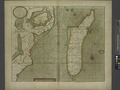 | 7 230 × 5 428 (112.28 megaocteti) | Fæ | GWToolset:: Creating mediafile for Fæ. Tranche 2.1206 |
Nexus ad fasciculum
Ad hunc fasciculum nectit:
Usus fasciculi per inceptus Vicimediorum
Quae incepta Vici fasciculo utuntur:
- Usus in en.wikipedia.org