
Fasciculus:1771 Bonne Map of the Guinea Coast of West Africa and the Cape Verde Islands - Geographicus - Guinea-bonne-1771.jpg

Mensura huius perspectionis: 439 × 599 elementa imaginalia. Aliae mensurae: 176 × 240 elementa imaginalia | 352 × 480 elementa imaginalia | 563 × 768 elementa imaginalia | 751 × 1 024 elementa imaginalia | 1 502 × 2 048 elementa imaginalia | 2 933 × 4 000 elementa imaginalia.
Sua resolutio (2 933 × 4 000 elementa imaginalia, magnitudo fasciculi: 2.29 megaocteti, typus MIME: image/jpeg)
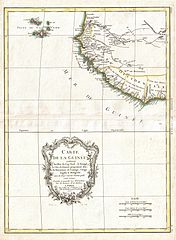
| Rigobertus Bonne: Carte de la Guinee contenant les Isles du Cap Verd, le Senegal, la Cote de Guinee proprement dite, les Royaumes de Loango, Congo, Angola, et Benguela avec les Pays voisins autant qu'ils sont connus.
( |
|||||||||||||||||||||||
|---|---|---|---|---|---|---|---|---|---|---|---|---|---|---|---|---|---|---|---|---|---|---|---|
| Artifex |
|
||||||||||||||||||||||
| Titulus |
Carte de la Guinee contenant les Isles du Cap Verd, le Senegal, la Cote de Guinee proprement dite, les Royaumes de Loango, Congo, Angola, et Benguela avec les Pays voisins autant qu'ils sont connus. |
||||||||||||||||||||||
| Descriptio |
English: A beautiful example of Rigobert Bonne's c. 1770 decorative map of western Africa. Covers from the Cape Verde Islands eastward to the coasts of Africa and the western mouth of the Niger River. Includes the modern day nations of Mauritania, Senegal, Gambia, Guinea-Bissau, Guinea, Sierra Leone, Liberia and Cote d'Ivoire. A decorative title cartouche appears in the lower left hand quadrant. Drawn by R. Bonne in 1770 for issue as plate no. A 30 in Jean Lattre's 1776 issue of the Atlas Moderne . |
||||||||||||||||||||||
| Datum | 1771 (dated) | ||||||||||||||||||||||
| Dimensions | Altitudo: 17 in (43.1 cm); Latitudo: 13 in (33 cm) | ||||||||||||||||||||||
| Accession number |
Geographicus link: Guinea-bonne-1771 |
||||||||||||||||||||||
| Source/Photographer |
Lattre, Jean, Atlas Moderne ou Collection de Cartes sur Toutes les Parties du Globe Terrestre, c. 1775.
|
||||||||||||||||||||||
| Permissio (Reusing this file) |
|
||||||||||||||||||||||
| Other versions | |||||||||||||||||||||||

Historia fasciculi
Presso die vel tempore fasciculum videbis, sicut tunc temporis apparuit.
| Dies/Tempus | Minutio | Dimensiones | Usor | Sententia | |
|---|---|---|---|---|---|
| recentissima | 03:17, 23 Martii 2011 | | 2 933 × 4 000 (2.29 megaocteti) | BotMultichillT | {{subst:User:Multichill/Geographicus |link=http://www.geographicus.com/P/AntiqueMap/Guinea-bonne-1771 |product_name=1771 Bonne Map of the Guinea Coast of West Africa and the Cape Verde Islands |map_title=Carte de la Guinee contenant les Isles du Cap Verd, |
Nexus ad fasciculum
Nullae paginae hoc fasciculo utuntur.
Usus fasciculi per inceptus Vicimediorum
Quae incepta Vici fasciculo utuntur:
- Usus in en.wikipedia.org
- Usus in es.wikipedia.org
- Usus in fr.wikipedia.org
- Usus in he.wikipedia.org
- Usus in uk.wikipedia.org
- Usus in zh.wikipedia.org